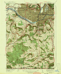
1942 Map of Binghamton West
USGS Topo · Published 1942About this map
The Susquehanna River and Chenango River converge in this 1940s survey, marking a dense landscape of industry and community institutions. In the northern reaches, the Erie RR and Delaware Lackawanna and Western RR navigate the corridor between Gray Island and Mt Prospect, serving the developed areas of Oakdale and Stella. Public institutions are remarkably prominent, ranging from the Binghamton Hospital and Court House to the Childrens Home and Armory.
Find a feature on this map
67 named features on this map. Tap any name to fly to it.
Don’t see what you’re looking for? This feature index may not catch every label — zoom into the map to look around manually.
Map Details
Editions of this 1942 Binghamton West Map
2 editions found
Other maps of this area

1901 · Apalachin
USGS Topo · 1:62,500

1904 · Binghamton
USGS Topo · 1:62,500

1904 · Apalachin
USGS Topo · 1:62,500

1906 · Catatonk
USGS Topo · 1:125,000

1934 · Castle Creek
USGS Topo · 1:24,000

1935 · Binghamton West
USGS Topo · 1:24,000

1935 · Chenango Forks
USGS Topo · 1:24,000

1937 · Binghamton East
USGS Topo · 1:24,000

1942 · Binghamton West
USGS Topo · 1:31,680

1942 · Castle Creek
USGS Topo · 1:31,680