Old Maps of Yardley, Bucks County for Hiking & Exploration
Hike through history with 35 historic maps of Yardley. Explore old trails, ghost towns, and forgotten backroads — perfect for outdoor adventurers and local explorers.
- Rediscover forgotten places: Map out old mining camps, roads, and footpaths that no longer exist on modern maps.
- Layer with modern tools: Combine with LiDAR or satellite views to plan hikes through historical terrain.
- Made for exploration: Popular among hikers, overlanders, and local history lovers.
Use these maps to find adventure and explore the hidden past of Yardley.
Yardley, Bucks County maps
(35)- 1890 Map of Lambertville
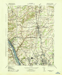
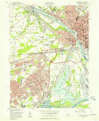
 1890 Lambertville1890 Print · USGSThe Delaware River valley thrived at the end of the nineteenth century as a hub for both canal and rail transport. Genealogists can trace family names and legacy sites near Lambertville, Washington's Crossing, and the junctions at Ringoes.
 - 1890 Map of Burlington
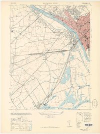
 1890 Burlington1890 Print · USGSThe Delaware River corridor was a thriving network of canal commerce and rail lines in the late nineteenth century. Genealogists and historians can trace family-named landings and early settlements like Dunks Ferry, Hulmeville, and the State Lunatic Asylum near Trenton.
 - 1891 Map of Lambertville
 1891 Lambertville1891 Print · USGSThe Delaware River valley in the late 1880s is captured here at the height of the canal and rail era. Genealogists and historians can trace the early footprints of Lambertville, the course of the Delaware and Raritan Canal Feeder, and crossroads like Ringoes.
 - 1893 Map of Burlington
 1893 Burlington1893 Print · USGSThe Delaware River valley thrived as a corridor of rail and river commerce in the late nineteenth century. Genealogists and historians can trace defunct transport hubs like Dunks Ferry, explore the grounds of the State Lunatic Asylum, and locate old stops along the Philadelphia and Newtown Railroad.3 unique versions available
 - 1894 Map of Lambertville
 1894 Lambertville1894 Print · USGSThe Delaware River valley was a thriving hub of 19th-century commerce, where twin canals and the Belvidere Division railroad powered local industry. Researchers can trace ancestral lands through numerous family-named landmarks like Muirheads and Larison Corner, or locate the exact 1890s footprints of Lambertville and Hopewell.4 unique versions available
 - 1904 Map of Burlington, 1958 Print
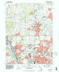
 1904 Burlington1958 Print · USGSThe Delaware River corridor thrives during the early twentieth century as a hub of rail, canal, and river commerce. Genealogists and local historians can trace family roots through riverside landings like Borton Landing or follow the legacy of institutions such as the George School and the State Lunatic Asylum.
 - 1906 Map of Lambertville
 1906 Lambertville1906 Print · USGSThe Delaware River valley in the early 1900s is shown in transition, where water-borne trade meets the expanding rail network. Genealogists and historians can trace family-named corners like Vanlieu Corners and Marshalls Corner alongside the Delaware and Raritan Canal.6 unique versions available
 - 1906 Map of Burlington
 1906 Burlington1906 Print · USGSThe Delaware River corridor was a bustling hub of rail and water transport in the early 1900s. Genealogists and local historians can trace the development of riverside wharves like Andalusia Wharf and institutional landmarks such as the State Lunatic Asylum.6 unique versions available
 - 1907 Map of Trenton
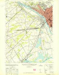
 1907 Trenton1907 Print · USGSThe Delaware River valley hums with turn-of-the-century industry and transport as river canals and railroads converge between New Jersey and Pennsylvania. Genealogists and local historians can trace the footprint of the George School, find early post offices like Holland PO, or locate old mill sites such as Blackwells Mills.4 unique versions available
 - 1942 Map of Burlington
 1942 Burlington1942 Print · USGSThe Delaware River valley thrived at the start of the 1940s as a hub of heavy rail and river commerce. Genealogists and local historians can trace family-named sites and old transit points like Dunks Ferry, Borton Landing, and Neshaminy Falls.
 - 1943 Map of Pennington
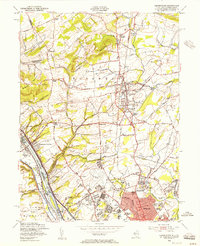
 1943 Pennington1943 Print · USGSThe Delaware River borderlands between New Jersey and Pennsylvania are captured here during the Second World War. Genealogists and historians can trace riverside landmarks like Scudders Falls, old family hamlets like Bear Tavern, and the early footprint of Mercer Airport.
 - 1944 Map of Trenton West, 1950 Print
 1944 Trenton West1950 Print · USGSThe Delaware River corridor near Trenton and Morrisville is captured here at the height of its mid-century rail and industrial era. Genealogists and historians can trace old property boundaries and landmarks from Fallsington to the landmark Wm Trent House 1719.
 - 1944 Map of Newark, 1971 Print
 1944 Newark1971 Print · USGSThe industrial corridor from Philadelphia to New York was in a period of massive transition during the mid-forties. Genealogists and researchers can trace the rail lines of the Lehigh Valley RR, locate military installations like Picatinny Arsenal, and explore the early sprawl near Levittown.5 unique versions available
 - 1947 Map of Trenton West
 1947 Trenton West1947 Print · USGSThe Delaware River corridor near Trenton and Morrisville was a hive of rail and river activity just after the war. Genealogists and local historians can trace the foundations of Fallsington, locate the Wm Trent House 1719, and follow the Reading Company line through Woodside.
 - 1949 Map of Newark
 1949 Newark1949 Print · USGSThe industrial corridor between Philadelphia and New York comes alive in this post-war survey. Genealogists and historians can trace the massive rail networks of the Reading Railroad and locate major installations like Fort Dix or Picatinny Arsenal.2 unique versions available
 - 1954 Map of Pennington, 1956 Print
 1954 Pennington1956 Print · USGSMid-century Mercer County was a landscape of expanding educational institutions and quiet crossroads hamlets. Genealogists and historians can trace the growth of Ewing and Pennington, as well as landmarks like Bear Tavern, St Hedwigs Cem, and the Reading railroad line.6 unique versions available
 - 1955 Map of Trenton West, 1957 Print
 1955 Trenton West1957 Print · USGSThe Delaware Valley transformed during the mid-fifties as planned communities like Levittown and Fairless Hills rose beside the river. Researchers can trace early suburban development through family-centric neighborhoods like Oaktree Hollow and landmarks like Rider College or the 3 M Airport.5 unique versions available
 - 1956 Map of Newark
 1956 Newark1956 Print · USGSThe industrial heart of the Mid-Atlantic is captured here at the dawn of the highway era, tracing the dense corridors between Newark and Philadelphia. Genealogists and local historians can map the rail networks of the Reading RR or locate mid-century military life at Fort Dix Military Reservation.2 unique versions available
 - 1957 Map of Newark
 1957 Newark1957 Print · USGSThe industrial and military heart of the Mid-Atlantic is mapped during its post-war suburban boom. Genealogists and historians can trace the intricate rail corridors of the Reading Railroad and locate key landmarks from Princeton University to Fort Hancock.
 - 1960 Map of Newark
 1960 Newark1960 Print · USGSThe industrial heart of the Mid-Atlantic is shown at mid-century, stretching from the dense urban centers of Newark and Philadelphia to the Blue Mountain ridges. Researchers can trace historic rail lines, coastal defenses at Fort Hancock, and the riverfront growth of Trenton and Easton.3 unique versions available
 - 1964 Map of Newark
 1964 Newark1964 Print · USGSGreater New Jersey and eastern Pennsylvania appear at the peak of their industrial and rail-centered development in the mid-sixties. Genealogists and historians can trace the paths of the Pennsylvania RR, identify mid-century landmarks like CAMP KILMER, or follow the Schuylkill River through READING.2 unique versions available
 - 1982 Map of Trenton, 1983 Print
 1982 Trenton1983 Print · USGSCentral New Jersey and the Delaware River valley are captured in the early eighties during a time of major highway expansion and suburban maturation. Researchers can trace the grounds of Princeton University, the historic Monmouth Battlefield, and the sprawling Fort Dix.
 - 1986 Map of Trenton, 1987 Print
 1986 Trenton1987 Print · USGSCentral New Jersey and the Delaware River valley are shown here during the mid-eighties, a period of dense suburban growth and military activity. Researchers can trace the sprawling grounds of the Fort Dix Military Reservation and the historic corridors of the Delaware & Raritan Canal State Park.
 - 1995 Map of Pennington, 1998 Print
 1995 Pennington1998 Print · USGSMercer County at the close of the century shows a unique mix of Revolutionary War sites and modern institutional growth. Researchers can trace family sites at St Hedwigs Cemetery or explore landmarks like Bear Tavern and Twin Pine Airport.
 - 1995 Map of Trenton West, 1998 Print
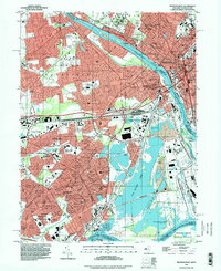 1995 Trenton West1998 Print · USGSThe Delaware River corridor between Trenton and Levittown is captured here in the mid-nineties, showing decades of suburban and industrial evolution. Trace local family history through Riverview Cemetery, St Andrews Ch, and the many schools like William Penn High Sch.
Showing maps 1-25 of 35
Frequently asked questions
- What are the different types of historical maps available for Yardley?
- What is the oldest map of Yardley?
- Where can I purchase historical maps of Yardley for my home or office?
- Where can I download high-res historical maps of Yardley?
- Are there historical topographic maps available for Yardley?
- Is there historical aerial imagery available for Yardley?
- Where are historical maps of Yardley sourced from?