1910s Maps of Worth Township, Pennsylvania
Explore 2 historic maps of Worth Township from the 1910s. These maps offer a rare glimpse into what life looked like during the 1910s — showing old roads, neighborhoods, homes, and landmarks that have changed or disappeared over time.
Whether you're researching your family's past, planning a metal detecting trip, or studying how Worth Township's landscape evolved across the 1910s, these high-resolution maps are a powerful tool for exploring the history of this region.
- Focus on a specific era: All maps on this page are from the 1910s, giving you a focused view of this time period.
- See what’s changed: Compare century-old streets, trails, and buildings to today's modern landscape using overlays and satellite layers.
- Research with precision: Use these maps for genealogy, historical research, land use analysis, or educational projects.
- View, download, or print: Maps are fully viewable online in high resolution, and can be downloaded or printed for your own records.
Start exploring Worth Township's history through authentic maps from the 1910s. This is your window into the past.
Worth Township, PA maps
(2)- 1910 Map of Zelienople
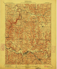 1910 Zelienople1910 Print · USGSWestern Pennsylvania in the early twentieth century is a landscape of thriving creek-side towns and intersecting rail lines. Genealogists can trace family roots through numerous rural landmarks like McConnells Mill, Zion Church, and the many country schoolhouses including American School.5 unique versions available
 - 1913 Map of Mercer
 1913 Mercer1913 Print · USGSMercer and Grove City anchor this early twentieth-century landscape during a period of coal mining and railway expansion. Genealogists can trace family roots through numerous local schools like Bottle Hill School and rural settlements such as Pardoe and Amsterdam.6 unique versions available
End of results
Showing maps 1-2 of 2
Top cities near Worth Township
- New Castle historical maps
- Butler historical maps
- Beaver Falls historical maps
- Grove City historical maps
- Ellwood City historical maps
- North Sewickley historical maps
See more
Top neighborhoods of Worth Township
Frequently asked questions
- What are the different types of historical maps available for Worth Township?
- What is the oldest map of Worth Township?
- Where can I purchase historical maps of Worth Township for my home or office?
- Where can I download high-res historical maps of Worth Township?
- Are there historical topographic maps available for Worth Township?
- Is there historical aerial imagery available for Worth Township?
- Where are historical maps of Worth Township sourced from?