1990s Maps of New London Township, Pennsylvania
Explore 7 historic maps of New London Township from the 1990s. These maps offer a rare glimpse into what life looked like during the 1990s — showing old roads, neighborhoods, homes, and landmarks that have changed or disappeared over time.
Whether you're researching your family's past, planning a metal detecting trip, or studying how New London Township's landscape evolved across the 1990s, these high-resolution maps are a powerful tool for exploring the history of this region.
- Focus on a specific era: All maps on this page are from the 1990s, giving you a focused view of this time period.
- See what’s changed: Compare century-old streets, trails, and buildings to today's modern landscape using overlays and satellite layers.
- Research with precision: Use these maps for genealogy, historical research, land use analysis, or educational projects.
- View, download, or print: Maps are fully viewable online in high resolution, and can be downloaded or printed for your own records.
Start exploring New London Township's history through authentic maps from the 1990s. This is your window into the past.
New London Township, PA maps
(7)- 1992 Map of Bay View, 1993 Print
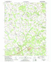 1992 Bay View1993 Print · USGSMaryland and Pennsylvania meet in this early 1990s record of northeastern Cecil County, showing a landscape defined by rolling creeks and rural crossroads. Genealogists and historians can locate Rosebank Cem, Elk Mills, and the historic Covered Bridge near Peacedale.
 - 1992 Map of Newark West, 1993 Print
 1992 Newark West1993 Print · USGSThe borderlands of Maryland, Delaware, and Pennsylvania are shown in the early nineties, centered on the equestrian landscapes of Fair Hill. Trace family roots at the Welsh Tract Ch or locate the Fair Hill Training Center and Elk Mills.3 unique versions available
 - 1992 Map of Oxford, 1995 Print
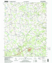
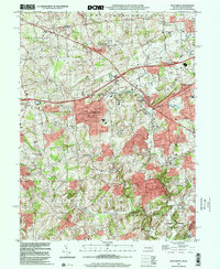
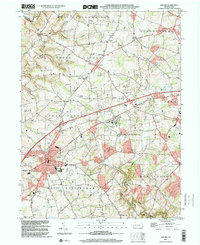
 1992 Oxford1995 Print · USGSChester County at the close of the twentieth century shows a landscape of historic townships and academic roots. Genealogists and local researchers can trace family lands near Lincoln University, the borough of Oxford, and old sites like Faggs Manor or Elkridge Cem.2 unique versions available
 - 1997 Map of West Grove, 1999 Print
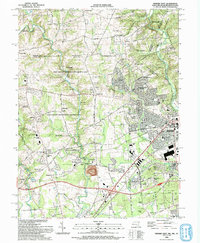
 1997 West Grove1999 Print · USGSChester County's rural character is well-preserved in the late nineties, anchored by the crossroads at West Grove and Avondale. Researchers can locate historic rural sites like New London Academy, the Penn Central line, and the St Francis Xavier Ch.
 - 1997 Map of Bay View, 1999 Print
 1997 Bay View1999 Print · USGSMaryland's northern border with Pennsylvania comes into focus in the late nineties, showcasing a landscape of established crossroads and rural institutions. Genealogists and historians can trace family lines through sites like Mt Olivet Cem, St Johns Ch Cem, and the community of Lombard.
 - 1999 Map of West Grove, 2001 Print
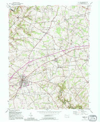
 1999 West Grove2001 Print · USGSChester County at the turn of the millennium shows a landscape of established villages and interconnected creek branches. Genealogists and researchers can trace local landmarks from West Grove to Landenberg, including the New London Academy and St Marys Cem.
 - 1999 Map of Oxford, 2001 Print
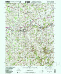
 1999 Oxford2001 Print · USGSSouthern Chester County at the turn of the millennium shows a landscape of historic schoolhouses and university grounds. Genealogists and historians can trace the foundations of local communities through Lincoln University, the Faggs Manor Cem, and rural crossroads like Russellville.
End of results
Showing maps 1-7 of 7
Top cities near New London Township
- Newark historical maps
- Elkton historical maps
- Hockessin historical maps
- Coatesville historical maps
- Havre de Grace historical maps
- Caln Township historical maps
See more
Frequently asked questions
- What are the different types of historical maps available for New London Township?
- What is the oldest map of New London Township?
- Where can I purchase historical maps of New London Township for my home or office?
- Where can I download high-res historical maps of New London Township?
- Are there historical topographic maps available for New London Township?
- Is there historical aerial imagery available for New London Township?
- Where are historical maps of New London Township sourced from?