Old Maps of Clarion County, Pennsylvania
Explore 159 old maps of Clarion County, spanning from 1900 to today. These high-resolution historic maps reveal how streets, neighborhoods, landmarks, and natural features evolved over time — perfect for genealogy, metal detecting, research, and local history exploration.
What you can do with these maps:
- See how Clarion County changed over time: Compare historical maps to modern-day views to trace roads, homesites, rail lines & more.
- View detailed metadata: Each map includes creators, publishers, year, scale, and archive source.
- Overlay maps with satellite & LiDAR: Visualize the past alongside modern tools to explore terrain & human change.
- Trusted historical sources: Maps sourced from the USGS, Library of Congress, and other archives.
- Access maps your way: View online, download high-res files, or order prints for personal or research use.
Start exploring old maps of Clarion County to uncover forgotten places, hidden landmarks, and the deep history beneath your feet.
Clarion County, PA maps
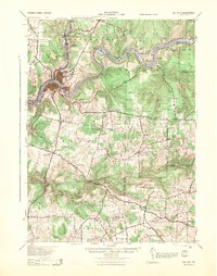
(159)- 1900 Map of Kittanning, 1963 Print
 1900 Kittanning1963 Print · USGSThe Allegheny River valley was a bustling corridor of rail and river industry at the turn of the century. Genealogists and researchers can trace family landmarks and early industrial sites like Redbank Furnace, Laceys Store, and Buffalo Mills.
 - 1901 Map of Rural Valley, 1957 Print
 1901 Rural Valley1957 Print · USGSArmstrong County’s river valleys and iron-working hamlets are captured here at the start of the twentieth century. Researchers can trace the legacy of early industry at Mahoning Furnace or follow the path of the Pennsylvania R.R. through Templeton.2 unique versions available
 - 1902 Map of Kittanning
 1902 Kittanning1902 Print · USGSThe Allegheny River corridor at the start of the twentieth century shows a region shaped by heavy rail and early industry. Trace family roots and old commercial sites like Redbank Furnace, East Brady, and the milling hub at Worthington.6 unique versions available
 - 1903 Map of Rural Valley
 1903 Rural Valley1903 Print · USGSArmstrong County at the dawn of the twentieth century shows a landscape defined by iron furnaces and winding river valleys. Genealogists can trace family roots in early settlements like Templeton, Goheenville, and Putneyville or locate landmarks such as Mahoning Furnace and Stone House.6 unique versions available
 - 1906 Map of Clarion
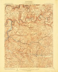
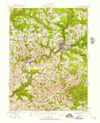
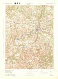
 1906 Clarion1906 Print · USGSClarion County at the turn of the century is defined by its deep river valleys and a bustling network of narrow-gauge railroads and coal mines. Genealogists and historians can trace dozens of rural schoolhouses and churches, from Concord Church to the Burma (Five Points) School and the early mines of Rimersburg.2 unique versions available
 - 1907 Map of Clarion
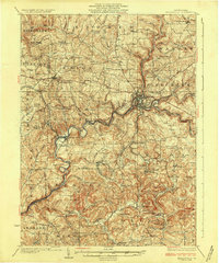
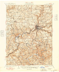
 1907 Clarion1907 Print · USGSClarion County at the dawn of the twentieth century shows a landscape shaped by coal mining and a complex rail network. Genealogists can locate specific family landmarks like Acme Mines, Concord Church, and rural outposts such as Limestone P.O..5 unique versions available
 - 1907 Map of Foxburg, 1953 Print
 1907 Foxburg1953 Print · USGSThe river-and-rail economies of Clarion and Armstrong counties are on full display in this early 1900s survey. Genealogists and industrial historians can trace vanished post offices like Perryville Pollock PO, early iron works at Canoe Furnace, and the riverside tracks of the Pennsylvania railroad.2 unique versions available
 - 1908 Map of Foxburg
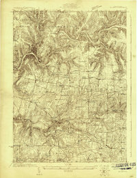
 1908 Foxburg1908 Print · USGSThe Pennsylvania river valleys thrive during the early twentieth-century industrial boom, as river traffic and railroads intersect in the heart of the coal and iron region. Researchers can locate early post offices at New Salem Lamartine PO, industrial sites like Sarah Furnace, and the Blue Goose Mine.5 unique versions available
 - 1918 Map of Loleta
 1918 Loleta1918 Print · USGSThe Pennsylvania timber and rail country comes to life in this late-war tactical survey of the Clarion River valley. Genealogists and researchers can trace the early footprints of Marienville, Clarington, and the now-quiet settlement of Loleta.
 - 1922 Map of Oil City
 1922 Oil City1922 Print · USGSVenango County's river-driven economy and rural community structure are captured here in the early twenties, showing the intersection of heavy rail and upland farming. Researchers can trace family origins through numerous rural school sites like Rose School and old post offices at Cranberry PO or Davis Corners.2 unique versions available
 - 1922 Map of Tionesta, 1953 Print
 1922 Tionesta1953 Print · USGSNorthwestern Pennsylvania in the early twenties reveals a landscape defined by timber, the Allegheny River, and a dense network of country schools. Researchers can trace the legacy of small communities like Lucinda, Newmansville, and Fryburg alongside early railroad corridors.3 unique versions available
 - 1924 Map of Oil City
 1924 Oil City1924 Print · USGSVenango County's industrial river valleys and rural plateaus are captured here in the early twenties as the oil economy shaped the land. Genealogists can trace family roots through numerous country schools and post offices like Cranberry PO, Monarch Park, and St Marks Church.4 unique versions available
 - 1924 Map of Tionesta
 1924 Tionesta1924 Print · USGSThe northern Pennsylvania plateau comes alive in the early 1920s as the Allegheny National Forest was being established. Genealogists can trace hundreds of family-named landmarks and rural schoolhouses like Amsler School and Helen Furnace along the Baltimore and Ohio rail lines.4 unique versions available
 - 1924 Map of Brookville, 1957 Print
 1924 Brookville1957 Print · USGSJefferson County in the early 1920s is captured here at a peak of rural development, showing a landscape defined by rail lines and small creek-side settlements. Genealogists can locate dozens of country schools and churches, from Mead Chapel to the Smith School and Ramsaytown.2 unique versions available
 - 1926 Map of Brookville
 1926 Brookville1926 Print · USGSJefferson County at the peak of its rail-and-river industrial era is captured in this survey of the northern coalfields. Genealogists and historians can trace family land near Brookville or locate vanished rural schoolhouses like Hazel Dell School and Mead Chapel.3 unique versions available
 - 1936 Map of Marienville
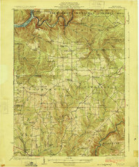
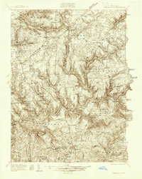 1936 Marienville1936 Print · USGSThe Pennsylvania highlands between the Clarion River and Allegheny National Forest appear here in the mid-1930s. Researchers can trace the Baltimore and Ohio RR through Marienville or locate family landmarks like Donnely Cem and Greenwood Ch.3 unique versions available
 - 1941 Map of Marienville
 1941 Marienville1941 Print · USGSForest, Clarion, and Jefferson counties meet along the winding Clarion River in this pre-war survey of northern Pennsylvania's timberlands. Genealogists can locate numerous rural schoolhouses and social landmarks like Kahletown Hall, Greenwood Ch, and the Downey Cem.3 unique versions available
 - 1943 Map of Oil City, 1944 Print
 1943 Oil City1944 Print · USGSVenango County oil country is shown in detail during the early 1940s, centered on the industrial hub of Oil City. Genealogists can trace family names through dozens of rural schools like McCalmont Sch and churches such as St Marks Ch or Hoag Hill Ch.
 - 1944 Map of Brookville
 1944 Brookville1944 Print · USGSThe Jefferson and Clarion County borderlands come alive in the 1940s, showing a landscape defined by river-valley railroads and rural school districts. Researchers can trace the lineage of local communities through landmarks like Mead Chapel, the mining works at Conifer, and old post offices in Worthville or Markton.
 - 1946 Map of Tionesta
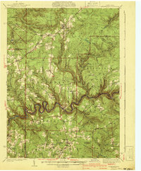
 1946 Tionesta1946 Print · USGSClarion and Forest Counties appear here in the 1940s, a period when rural schoolhouses and family-named hamlets still defined the interior ridges. Researchers can trace the Allegheny River and Clarion River or find specific landmarks like the Oil Field and Highland Township High Sch.
 - 1949 Map of Brookville
 1949 Brookville1949 Print · USGSJefferson County settlement at the end of the 1940s centers on the river junctions and rail lines near Brookville. Genealogists can trace family footprints across dozens of country schoolhouses like Oaks School and villages like Summerville or Knoxdale.
 - 1953 Map of Pittsburgh
 1953 Pittsburgh1953 Print · USGSWestern Pennsylvania's industrial landscape at the start of the fifties shows the steel and rail corridors between Pittsburgh and Altoona. Trace family roots in river towns like Tarentum or follow the Pennsylvania Turnpike across Laurel Hill.
 - 1954 Map of Pittsburgh
 1954 Pittsburgh1954 Print · USGSWestern Pennsylvania in the early fifties remains a powerhouse of heavy industry and vital transit corridors. Genealogists and historians can trace the rail-and-river network connecting Pittsburgh, Johnstown, and Altoona via the Pennsylvania RR and the Lincoln Highway.2 unique versions available
 - 1957 Map of Warren, 1964 Print
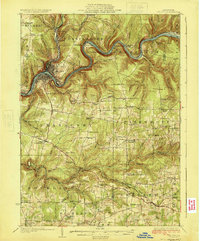
 1957 Warren1964 Print · USGSThe northern Pennsylvania oil and timber country comes into focus in the mid-fifties, showing the region before modern highway expansions. Trace the industrial rail networks of the Pennsylvania RR and the early Allegheny River Reservoir near Warren and Oil City.4 unique versions available
 - 1958 Map of Pittsburgh
 1958 Pittsburgh1958 Print · USGSWestern Pennsylvania in the late fifties shows an industrial heartland defined by the confluence of the Allegheny River and Monongahela River. Researchers can trace the sprawling rail networks of the Pennsylvania RR and find established towns like Butler, Latrobe, and Windber.5 unique versions available
Showing maps 1-25 of 159
Top cities of Clarion County
- Clarion historical maps
- Limestone Township historical maps
- Toby Township historical maps
- Knox historical maps
- Rimersburg historical maps
- New Bethlehem historical maps
See more
Frequently asked questions
- What are the different types of historical maps available for Clarion County?
- What is the oldest map of Clarion County?
- Where can I purchase historical maps of Clarion County for my home or office?
- Where can I download high-res historical maps of Clarion County?
- Are there historical topographic maps available for Clarion County?
- Is there historical aerial imagery available for Clarion County?
- Where are historical maps of Clarion County sourced from?