Old Maps of Beech Creek Township, Pennsylvania
Explore 31 old maps of Beech Creek Township, spanning from 1921 to today. These high-resolution historic maps reveal how streets, neighborhoods, landmarks, and natural features evolved over time — perfect for genealogy, metal detecting, research, and local history exploration.
What you can do with these maps:
- See how Beech Creek Township changed over time: Compare historical maps to modern-day views to trace roads, homesites, rail lines & more.
- View detailed metadata: Each map includes creators, publishers, year, scale, and archive source.
- Overlay maps with satellite & LiDAR: Visualize the past alongside modern tools to explore terrain & human change.
- Trusted historical sources: Maps sourced from the USGS, Library of Congress, and other archives.
- Access maps your way: View online, download high-res files, or order prints for personal or research use.
Start exploring old maps of Beech Creek Township to uncover forgotten places, hidden landmarks, and the deep history beneath your feet.
Beech Creek Township, PA maps
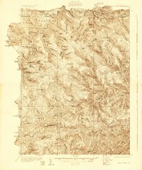
(31)- 1921 Map of Howard
 1921 Howard1921 Print · USGSThe valleys and ridges of Central Pennsylvania are captured here just as the rail-and-river economy was maturing. Researchers can trace family sites among a high density of rural schools and churches like Cedar Spring School, Hunter Run Church, and the town of Lamar.3 unique versions available
 - 1923 Map of Howard
 1923 Howard1923 Print · USGSThe valleys of Clinton and Center counties were bustling with rural life in the 1920s as the rail and river economy matured. Genealogists can locate over a dozen local schoolhouses like Wagner School and trace the paths of the Pennsylvania Railroad and Beech Creek Sta.6 unique versions available
 - 1928 Map of Snow Shoe
 1928 Snow Shoe1928 Print · USGSCentre County's coal and timber country is documented here in the late 1920s, showing the intersection of heavy industry and wilderness. Researchers can locate active operations like Mine No 25, the village of Gillintown, and the remote Soldiers Home Camp.5 unique versions available
 - 1931 Map of Show Shoe
 1931 Show Shoe1931 Print · USGSThe Pennsylvania coalfields and river valleys are captured here in the early 1930s, showing a rugged landscape defined by mountain camps and mining towns. Genealogists can trace family roots through industrial settlements like Clarence and Snow Shoe or locate old schools such as Cherry Run Sch.3 unique versions available
 - 1946 Map of Renovo West, 1953 Print
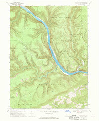
 1946 Renovo West1953 Print · USGSClinton County's river valleys and ridgelines come alive in this mid-century survey of the Pennsylvania wilds. Trace the industrial footprint of the Pennsylvania RR through Renovo or find family history at Laurel Hill Cem and Summerson Cem.9 unique versions available
 - 1946 Map of Keating, 1954 Print
 1946 Keating1954 Print · USGSClinton County’s deep river valleys and high ridges are shown just after the war, centered on the strategic rail junction at Keating. Genealogists and industrial historians can trace the New York Central line through the mountains and locate the settlement at Bitumen.4 unique versions available
 - 1948 Map of Keating
 1948 Keating1948 Print · USGSThe confluence of the Susquehanna and Sinnemahoning Creek appears in the late 1940s as a vital railroad corridor through the mountains. Genealogists and historians can trace the riverside rail stops at Keating and Wistar or the upland community of Bitumen.
 - 1954 Map of Williamsport
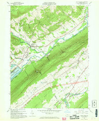
 1954 Williamsport1954 Print · USGSNorth-central Pennsylvania in the mid-fifties is defined by the winding West Branch Susquehanna River and its industrial valley. Local historians can trace the massive Susquehanna Ordnance Depot and the extensive rail networks of the Pennsylvania Railroad.
 - 1960 Map of Williamsport
 1960 Williamsport1960 Print · USGSNorth-central Pennsylvania in the mid-twentieth century was a vital corridor of rail and river industry stretching from the New York line to the coal regions. Genealogists can trace the rail networks of the Pennsylvania RR and Lehigh Valley RR connecting towns like Williamsport, Towanda, and Lock Haven.
 - 1960 Map of Snow Shoe NW, 1962 Print
 1960 Snow Shoe NW1962 Print · USGSThe West Branch of the Susquehanna winds through the high ridges of the Sproul State Forest at the start of the sixties. Genealogists and forest historians can trace the New York Central rail line, Nelson Cem, and the Panther Fire Tower.5 unique versions available
 - 1960 Map of Snow Shoe NE, 1962 Print
 1960 Snow Shoe NE1962 Print · USGSThe Clinton and Centre County borderlands in the early sixties reveal a landscape of deep hollows and remote wilderness camps. Researchers can trace the heritage of local outdoor life at sites like Ralpton Camp, Wildcat Camp, and the Bald Hill Hunting Club.3 unique versions available
 - 1960 Map of Snow Shoe SE, 1962 Print
 1960 Snow Shoe SE1962 Print · USGSThe industrial and forest landscapes of central Pennsylvania are captured here at the start of the 1960s. Researchers can trace the path of the New York Central and Hudson River RR through the Hogback Tunnel or locate family roots at Summit Hill Cem and Orviston.4 unique versions available
 - 1962 Map of Williamsport, 1966 Print
 1962 Williamsport1966 Print · USGSNorth-central Pennsylvania was a landscape of industrial river hubs and vast state woodlands in the early sixties. Researchers can trace the path of the Pennsylvania Railroad through Williamsport and explore the remote reaches of Bucktail State Park.5 unique versions available
 - 1965 Map of Williamsport
 1965 Williamsport1965 Print · USGSNorth-central Pennsylvania in the mid-1960s is defined by the industrial river towns and vast timberlands of the Allegheny Plateau. Researchers can trace historic rail lines like the Erie Lackawanna and Reading as they thread through Williamsport, Lock Haven, and Jersey Shore.
 - 1966 Map of Williamsport
 1966 Williamsport1966 Print · USGSThe Susquehanna Valley was a hub of transit and industry in the mid-seventies, where the river's West Branch connected major college towns and timberlands. Researchers can trace historical rail lines like the Reading or locate regional landmarks from Jersey Shore to Ricketts Glen State Park.
 - 1966 Map of Farrandsville, 1969 Print
 1966 Farrandsville1969 Print · USGSThe West Branch Susquehanna River corridor in the 1960s reveals a landscape of industrial transit and remote ridges. Genealogists can locate the riverside settlements of Farrandsville and Riverview, as well as Peoples Ch and upland strip mines.2 unique versions available
 - 1967 Map of Beech Creek, 1968 Print
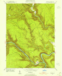
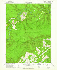
 1967 Beech Creek1968 Print · USGSClinton and Centre counties are captured in the late sixties during the creation of the Blanchard Reservoir. Genealogists and historians can trace family plots at Hays-Fearon Cem and explore community landmarks like Beech Creek Station and Liberty Ch.3 unique versions available
 - 1967 Map of Howard NW, 1968 Print
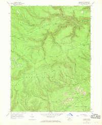 1967 Howard NW1968 Print · USGSClinton County’s deep woods and mining heritage are documented here in the late sixties, showing the remote highlands of Sproul State Forest. Researchers can trace old resource extraction routes and forest clearings like Eagleton Fields and several hillside Strip Mines.3 unique versions available
 - 1967 Map of Howard, 1969 Print
 1967 Howard1969 Print · USGSCentral Pennsylvania in the late sixties shows the intersection of the new Eagle Creek Reservoir and old mountain settlements. Local historians can trace the foundations of Howard and Orviston alongside remote sites like Schencks Cem and Highland Ch.3 unique versions available
 - 1977 Map of Beech Creek, 1979 Print
 1977 Beech Creek1979 Print · USGSClinton County land use and valley settlement are captured in this late 1970s aerial survey just as the rural landscape was maturing. Researchers can trace the exact field boundaries and homestead locations near Beech Creek and under the shadow of Bald Eagle Mountain.
 - 1977 Map of Howard, 1979 Print
 1977 Howard1979 Print · USGSCentre County farmland and ridges come into sharp focus during the late seventies, showing the rural character of the Pennsylvania landscape. Researchers can trace land use patterns near Howard and Romola or study the shoreline of Sayers Lake.
 - 1984 Map of Williamsport West, 1985 Print
 1984 Williamsport West1985 Print · USGSCentral Pennsylvania in the mid-eighties was a landscape of dense state forests and industrious river towns along the West Branch Susquehanna River. Trace the rail lines of Conrail through Renovo or locate the historic grounds of Lock Haven State College.2 unique versions available
 - 1995 Map of Snow Shoe SE, 1999 Print
 1995 Snow Shoe SE1999 Print · USGSThe rugged coal and timber lands of Centre County are captured here in the mid-1990s. Local researchers can trace the industrial footprint of Strip Mines and Tipples near Kato or locate family roots at Summit Hill Cem.
 - 2023 Map of Keating, 2023 Print
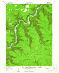
 2023 Keating2023 Print · USGSSettled at the confluence of Sinnemahoning Creek and the Susquehanna, this area was a vital waterway hub. Genealogists can trace family names at Bitumen and Saint Marys Catholic Cem or explore the terrain of Keating.
 - 2023 Map of Snow Shoe NW, 2023 Print
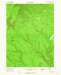
 2023 Snow Shoe NW2023 Print · USGSThe West Branch Susquehanna River divides Clinton and Centre counties in the early twenty-first century, shaping a landscape defined by deep hollows and high ridges. Researchers can trace local landmarks like Nelsonville Cem, the settlement of Birch, and the winding Chuck Keiper Trl.
Showing maps 1-25 of 31
Top cities near Beech Creek Township
- Lamar historical maps
- Mill Hall historical maps
- Milesburg historical maps
- Beech Creek historical maps
- Howard historical maps
- Curtin historical maps
See more
Top neighborhoods of Beech Creek Township
Frequently asked questions
- What are the different types of historical maps available for Beech Creek Township?
- What is the oldest map of Beech Creek Township?
- Where can I purchase historical maps of Beech Creek Township for my home or office?
- Where can I download high-res historical maps of Beech Creek Township?
- Are there historical topographic maps available for Beech Creek Township?
- Is there historical aerial imagery available for Beech Creek Township?
- Where are historical maps of Beech Creek Township sourced from?