1960s Maps of Randolph Township, Pennsylvania
Explore 6 historic maps of Randolph Township from the 1960s. These maps offer a rare glimpse into what life looked like during the 1960s — showing old roads, neighborhoods, homes, and landmarks that have changed or disappeared over time.
Whether you're researching your family's past, planning a metal detecting trip, or studying how Randolph Township's landscape evolved across the 1960s, these high-resolution maps are a powerful tool for exploring the history of this region.
- Focus on a specific era: All maps on this page are from the 1960s, giving you a focused view of this time period.
- See what’s changed: Compare century-old streets, trails, and buildings to today's modern landscape using overlays and satellite layers.
- Research with precision: Use these maps for genealogy, historical research, land use analysis, or educational projects.
- View, download, or print: Maps are fully viewable online in high resolution, and can be downloaded or printed for your own records.
Start exploring Randolph Township's history through authentic maps from the 1960s. This is your window into the past.
Randolph Township, PA maps
(6)- 1962 Map of Cleveland
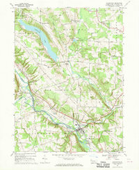
 1962 Cleveland1962 Print · USGSNortheast Ohio and the Pennsylvania borderlands appear here during the industrial peak of the early sixties. Genealogists and historians can trace the expansive rail lines of the Nickel Plate Road and the growth of suburbs from Parma to Lyndhurst.
 - 1967 Map of Cochranton, 1970 Print
 1967 Cochranton1970 Print · USGSPennsylvania's Crawford County comes into focus during the late 1960s, showing a landscape shaped by the French Creek valley and the Erie-Lackawanna railroad. Genealogists can trace family names at numerous crossroads like Frenchtown and Kasters Corners or locate local landmarks including St Marks Ch and Ponce de Leon Spring.2 unique versions available
 - 1967 Map of Blooming Valley, 1970 Print
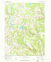
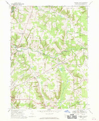 1967 Blooming Valley1970 Print · USGSCrawford County's rural landscape is captured here in the late 1960s, showing the agricultural heartland between Woodcock and Blooming Valley. Researchers can trace family roots at Mt Blair Cem & Ch, Woodcock Grange, and the crossroads of Fountain House Corners.4 unique versions available
 - 1967 Map of Dempseytown, 1972 Print
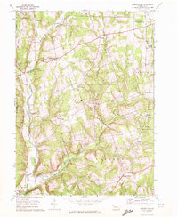 1967 Dempseytown1972 Print · USGSIn the hills of Venango County during the late sixties, rural life centered on small crossroads and local industry. Genealogists can trace family roots through locations like Dempseytown, Trinity Ch, and the Township Sch while exploring the region's oil wells.3 unique versions available
 - 1967 Map of Townville, 1972 Print
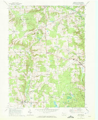 1967 Townville1972 Print · USGSCrawford County agriculture and conservation dominate the landscape in the late sixties. Genealogists and historians can trace family-named crossroads like Jewel Corners, find rural landmarks such as Bentley Ch, and explore the early bounds of the Erie National Wildlife Refuge.3 unique versions available
 - 1967 Map of Sugar Lake, 1972 Print
 1967 Sugar Lake1972 Print · USGSNorthwestern Pennsylvania's rural townships are captured here in the late sixties, showing a landscape defined by conservation and agriculture. Researchers can locate local landmarks like Black Ash Ch, the Brawley Cem, and the old settlement at Wilson Mills.2 unique versions available
End of results
Showing maps 1-6 of 6
Top cities near Randolph Township
- Meadville historical maps
- Oil City historical maps
- Cranberry Township historical maps
- Franklin historical maps
- Sugarcreek historical maps
- Cambridge Springs historical maps
See more
Top neighborhoods of Randolph Township
- Basil Corners historical maps
- Hickory Corners historical maps
- Mount Hope historical maps
- Turkey Track Corners historical maps
- Guys Mills historical maps
- Gilbert Corners historical maps
See more
Frequently asked questions
- What are the different types of historical maps available for Randolph Township?
- What is the oldest map of Randolph Township?
- Where can I purchase historical maps of Randolph Township for my home or office?
- Where can I download high-res historical maps of Randolph Township?
- Are there historical topographic maps available for Randolph Township?
- Is there historical aerial imagery available for Randolph Township?
- Where are historical maps of Randolph Township sourced from?