1940s Maps of Mount Hope, Randolph Township
Explore 1 historic maps of Mount Hope from the 1940s. These maps offer a rare glimpse into what life looked like during the 1940s — showing old roads, neighborhoods, homes, and landmarks that have changed or disappeared over time.
Whether you're researching your family's past, planning a metal detecting trip, or studying how Mount Hope's landscape evolved across the 1940s, these high-resolution maps are a powerful tool for exploring the history of this region.
- Focus on a specific era: All maps on this page are from the 1940s, giving you a focused view of this time period.
- See what’s changed: Compare century-old streets, trails, and buildings to today's modern landscape using overlays and satellite layers.
- Research with precision: Use these maps for genealogy, historical research, land use analysis, or educational projects.
- View, download, or print: Maps are fully viewable online in high resolution, and can be downloaded or printed for your own records.
Start exploring Mount Hope's history through authentic maps from the 1940s. This is your window into the past.
Mount Hope, Randolph Township maps
(1)- 1945 Map of Townville
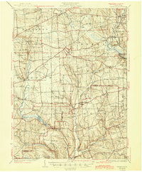 1945 Townville1945 Print · USGSCrawford and Venango Counties are documented here during the late 1920s and early 1940s, showing a landscape of small farming hamlets and rural school districts. Genealogists can trace family roots through numerous named locations like Hamilton Cors, Mt Hope Ch, and the many schools like Sugar Grove Sch.
End of results
Showing maps 1-1 of 1
Top cities near Mount Hope
- Meadville historical maps
- Oil City historical maps
- Cranberry Township historical maps
- Franklin historical maps
- Sugarcreek historical maps
- Cambridge Springs historical maps
See more
Frequently asked questions
- What are the different types of historical maps available for Mount Hope?
- What is the oldest map of Mount Hope?
- Where can I purchase historical maps of Mount Hope for my home or office?
- Where can I download high-res historical maps of Mount Hope?
- Are there historical topographic maps available for Mount Hope?
- Is there historical aerial imagery available for Mount Hope?
- Where are historical maps of Mount Hope sourced from?