1960s Maps of Troy Township, Pennsylvania
Explore 6 historic maps of Troy Township from the 1960s. These maps offer a rare glimpse into what life looked like during the 1960s — showing old roads, neighborhoods, homes, and landmarks that have changed or disappeared over time.
Whether you're researching your family's past, planning a metal detecting trip, or studying how Troy Township's landscape evolved across the 1960s, these high-resolution maps are a powerful tool for exploring the history of this region.
- Focus on a specific era: All maps on this page are from the 1960s, giving you a focused view of this time period.
- See what’s changed: Compare century-old streets, trails, and buildings to today's modern landscape using overlays and satellite layers.
- Research with precision: Use these maps for genealogy, historical research, land use analysis, or educational projects.
- View, download, or print: Maps are fully viewable online in high resolution, and can be downloaded or printed for your own records.
Start exploring Troy Township's history through authentic maps from the 1960s. This is your window into the past.
Troy Township, PA maps
(6)- 1967 Map of Dempseytown, 1972 Print
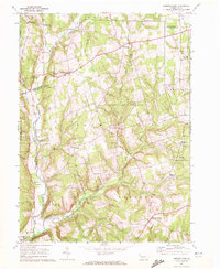 1967 Dempseytown1972 Print · USGSIn the hills of Venango County during the late sixties, rural life centered on small crossroads and local industry. Genealogists can trace family roots through locations like Dempseytown, Trinity Ch, and the Township Sch while exploring the region's oil wells.3 unique versions available
 - 1967 Map of Centerville, 1972 Print
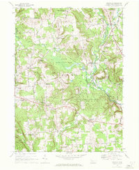 1967 Centerville1972 Print · USGSCrawford County in the late sixties reveals a network of rural hamlets and farming crossroads at a moment of transition. Researchers can trace family history through numerous named landmarks like Markley Corners, Troy Center, and East Troy Cem.2 unique versions available
 - 1967 Map of Townville, 1972 Print
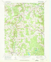 1967 Townville1972 Print · USGSCrawford County agriculture and conservation dominate the landscape in the late sixties. Genealogists and historians can trace family-named crossroads like Jewel Corners, find rural landmarks such as Bentley Ch, and explore the early bounds of the Erie National Wildlife Refuge.3 unique versions available
 - 1967 Map of Sugar Lake, 1972 Print
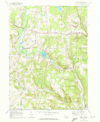 1967 Sugar Lake1972 Print · USGSNorthwestern Pennsylvania's rural townships are captured here in the late sixties, showing a landscape defined by conservation and agriculture. Researchers can locate local landmarks like Black Ash Ch, the Brawley Cem, and the old settlement at Wilson Mills.2 unique versions available
 - 1968 Map of Titusville South, 1971 Print
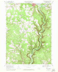 1968 Titusville South1971 Print · USGSThe oil region of Venango County is captured here in the late sixties, where the industrial legacy of the Oil Creek valley meets rural farm life. Researchers can trace the Penn Central line through historic sites like Drake Well State Park and Petroleum Center.5 unique versions available
 - 1968 Map of Titusville North, 1971 Print
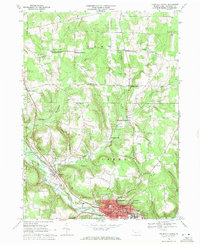 1968 Titusville North1971 Print · USGSCrawford County's oil-rich countryside and the northern limits of Titusville are captured here in the late sixties. Genealogists and historians can trace family-named sites like Gilson Ridge Cemetery, Thompsons Mills, and numerous Oil Wells scattered across the ridges.2 unique versions available
End of results
Showing maps 1-6 of 6
Top cities near Troy Township
- Oil City historical maps
- Cranberry Township historical maps
- Franklin historical maps
- Titusville historical maps
- Sugarcreek historical maps
- Cherrytree Township historical maps
See more
Top neighborhoods of Troy Township
- Luces Corners historical maps
- Troy Center historical maps
- Fauncetown historical maps
- Smith Corners historical maps
- Morehead Corners historical maps
- Altenburg Corners historical maps
See more
Frequently asked questions
- What are the different types of historical maps available for Troy Township?
- What is the oldest map of Troy Township?
- Where can I purchase historical maps of Troy Township for my home or office?
- Where can I download high-res historical maps of Troy Township?
- Are there historical topographic maps available for Troy Township?
- Is there historical aerial imagery available for Troy Township?
- Where are historical maps of Troy Township sourced from?