1950s Maps of South Middleton Township, Pennsylvania
Explore 7 historic maps of South Middleton Township from the 1950s. These maps offer a rare glimpse into what life looked like during the 1950s — showing old roads, neighborhoods, homes, and landmarks that have changed or disappeared over time.
Whether you're researching your family's past, planning a metal detecting trip, or studying how South Middleton Township's landscape evolved across the 1950s, these high-resolution maps are a powerful tool for exploring the history of this region.
- Focus on a specific era: All maps on this page are from the 1950s, giving you a focused view of this time period.
- See what’s changed: Compare century-old streets, trails, and buildings to today's modern landscape using overlays and satellite layers.
- Research with precision: Use these maps for genealogy, historical research, land use analysis, or educational projects.
- View, download, or print: Maps are fully viewable online in high resolution, and can be downloaded or printed for your own records.
Start exploring South Middleton Township's history through authentic maps from the 1950s. This is your window into the past.
South Middleton Township, PA maps
(7)- 1950 Map of Harrisburg, 1952 Print
 1950 Harrisburg1952 Print · USGSMid-century Central Pennsylvania comes alive through its dense rail networks and river valley settlements during the post-war industrial era. Genealogists and historians can trace family roots through hubs like Harrisburg, locate Carlisle Barracks, or follow the Pennsylvania RR through the Lebanon Valley.
 - 1952 Map of Mount Holly Springs, 1958 Print
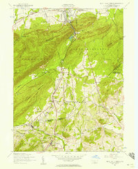 1952 Mount Holly Springs1958 Print · USGSCumberland and Adams counties meet at the mountain gaps of south-central Pennsylvania in the early 1950s. Trace the path of the Appalachian Trail and identify rural landmarks like the Telegraph relay station, Peach Glen, and Mt Zion Church.6 unique versions available
 - 1952 Map of Carlisle, 1958 Print
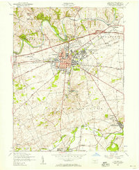 1952 Carlisle1958 Print · USGSCumberland County at the start of the 1950s shows a landscape defined by its strategic military history and emerging turnpike traffic. Researchers can trace family roots at Westminster Cemetery or locate old school sites like Union Hall School and the Basin Hill School.6 unique versions available
 - 1952 Map of Mechanicsburg, 1958 Print
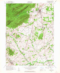
 1952 Mechanicsburg1958 Print · USGSCumberland County at mid-century shows a landscape of historic crossroad villages and burgeoning military infrastructure. Trace the early routes of the Appalachian Trail and find family-named landmarks like Leidighs, Churchtown, and Hickorytown.6 unique versions available
 - 1952 Map of Dillsburg, 1958 Print
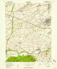
 1952 Dillsburg1958 Print · USGSDillsburg and the surrounding rural townships of York and Adams Counties are shown in the early fifties as the region balanced agriculture with growing community centers. Researchers can trace old family sites and rural landmarks like Deardorffs Mill, Sunny Side Cemetery, and the Appalachian Trail.5 unique versions available
 - 1952 Map of Carlisle, 1959 Print
 1952 Carlisle1959 Print · USGSCumberland County at the midpoint of the century shows a landscape defined by its historic military presence and the emerging Turnpike. Genealogists and hikers can trace the Appalachian Trail over Long Mountain or locate family sites at Churchtown and Deardorffs Mill.2 unique versions available
 - 1957 Map of Harrisburg
 1957 Harrisburg1957 Print · USGSMid-century Central Pennsylvania comes into focus as a bustling network of rail, river, and mountain ridges. Genealogists and historians can trace the development of the State Capitol and surrounding hubs like Middletown, Columbia, and Pottsville.7 unique versions available
End of results
Showing maps 1-7 of 7
Top cities near South Middleton Township
- Carlisle historical maps
- Lower Allen historical maps
- Middlesex Township historical maps
- Schlusser historical maps
- Enola historical maps
- Dickinson historical maps
See more
Top neighborhoods of South Middleton Township
- Bonny Brook historical maps
- Coyle historical maps
- Craighead historical maps
- Mount Zion historical maps
- Hatton historical maps
- Uriah historical maps
See more
Frequently asked questions
- What are the different types of historical maps available for South Middleton Township?
- What is the oldest map of South Middleton Township?
- Where can I purchase historical maps of South Middleton Township for my home or office?
- Where can I download high-res historical maps of South Middleton Township?
- Are there historical topographic maps available for South Middleton Township?
- Is there historical aerial imagery available for South Middleton Township?
- Where are historical maps of South Middleton Township sourced from?