1970s Maps of Reed Township, Pennsylvania
Explore 1 historic maps of Reed Township from the 1970s. These maps offer a rare glimpse into what life looked like during the 1970s — showing old roads, neighborhoods, homes, and landmarks that have changed or disappeared over time.
Whether you're researching your family's past, planning a metal detecting trip, or studying how Reed Township's landscape evolved across the 1970s, these high-resolution maps are a powerful tool for exploring the history of this region.
- Focus on a specific era: All maps on this page are from the 1970s, giving you a focused view of this time period.
- See what’s changed: Compare century-old streets, trails, and buildings to today's modern landscape using overlays and satellite layers.
- Research with precision: Use these maps for genealogy, historical research, land use analysis, or educational projects.
- View, download, or print: Maps are fully viewable online in high resolution, and can be downloaded or printed for your own records.
Start exploring Reed Township's history through authentic maps from the 1970s. This is your window into the past.
Reed Township, PA maps
(1)- 1977 Map of Halifax, 1984 Print
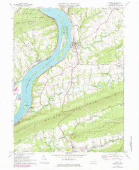 1977 Halifax1984 Print · USGSThe Susquehanna River corridor near Halifax is shown here in the late seventies, just as the valley's industrial and rail patterns were evolving. Researchers can trace family sites at New Buffalo, identify rural schools like Township Sch, and follow the Appalachian Trail over Peters Mountain.
End of results
Showing maps 1-1 of 1
Top cities near Reed Township
- Harrisburg historical maps
- Carlisle historical maps
- Colonial Park historical maps
- Progress historical maps
- New Cumberland historical maps
- Lower Allen historical maps
See more
Top neighborhoods of Reed Township
Frequently asked questions
- What are the different types of historical maps available for Reed Township?
- What is the oldest map of Reed Township?
- Where can I purchase historical maps of Reed Township for my home or office?
- Where can I download high-res historical maps of Reed Township?
- Are there historical topographic maps available for Reed Township?
- Is there historical aerial imagery available for Reed Township?
- Where are historical maps of Reed Township sourced from?