Old Maps of Delaware County, Pennsylvania
Explore 95 old maps of Delaware County, spanning from 1891 to today. These high-resolution historic maps reveal how streets, neighborhoods, landmarks, and natural features evolved over time — perfect for genealogy, metal detecting, research, and local history exploration.
What you can do with these maps:
- See how Delaware County changed over time: Compare historical maps to modern-day views to trace roads, homesites, rail lines & more.
- View detailed metadata: Each map includes creators, publishers, year, scale, and archive source.
- Overlay maps with satellite & LiDAR: Visualize the past alongside modern tools to explore terrain & human change.
- Trusted historical sources: Maps sourced from the USGS, Library of Congress, and other archives.
- Access maps your way: View online, download high-res files, or order prints for personal or research use.
Start exploring old maps of Delaware County to uncover forgotten places, hidden landmarks, and the deep history beneath your feet.
Delaware County, PA maps
(95)- 1891 Map of Philadelphia
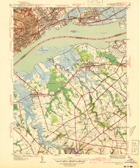
 1891 Philadelphia1891 Print · USGSPhiladelphia and its New Jersey neighbors are captured in the late Victorian era as rail and river commerce defined the region. Genealogists and historians can trace family-named sites and vanished river features like Windmill Island, Haddonfield, and the U.S. Navy Yard.
 - 1894 Map of Chester, 1954 Print
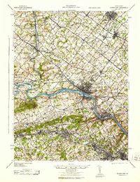
 1894 Chester1954 Print · USGSThe Delaware River corridor near Chester was a hive of rail activity and water-powered industry at the close of the century. Genealogists and historians can trace family-named mills such as Llewellyn Mills or visit the campus of the Williamson School and the borough of Media.2 unique versions available
 - 1894 Map of Philadelphia, 1958 Print
 1894 Philadelphia1958 Print · USGSPhiladelphia and Camden are shown at the height of the Victorian era, characterized by dense rail corridors and a bustling maritime waterfront. Genealogists and researchers can trace 19th-century neighborhoods and landmarks like Fort Mifflin, Paschallville, and the Alms House.
 - 1894 Map of Norristown, 1959 Print
 1894 Norristown1959 Print · USGSSoutheast Pennsylvania at the end of the nineteenth century reveals a landscape defined by the Schuylkill River and a dense network of early railroads. Researchers can trace ancestral roots through old settlements like Skippack, Lansdale, and the rail junctions of the Perkiomen RR and Stony Creek RR.
 - 1895 Map of Norristown, 1898 Print
 1895 Norristown1898 Print · USGSMontgomery County at the end of the 19th century is a landscape of thriving river towns and bustling rail corridors. Researchers can trace the Victorian-era footprints of Norristown and Lansdale or locate historic landmarks like Valley Forge and Perkiomen Bridge.11 unique versions available
 - 1896 Map of Philadelphia
 1896 Philadelphia1896 Print · USGSPhiladelphia and its South Jersey neighbors appear at a peak of late-nineteenth-century industrial and maritime expansion. Genealogists and historians can trace the early layouts of Woodbury and Gloucester, or locate landmarks like Fort Mifflin and the U.S. Navy Yard along the riverfront.
 - 1896 Map of Norristown
 1896 Norristown1896 Print · USGSMontgomery County in the mid-1890s reveals a landscape of growing railroad towns and historic creek-side settlements. Genealogists can trace family footprints near Waterloo Mills, the historic Perkiomen Bridge, and across the townships from Lansdale to Norristown.
 - 1896 Map of Chester
 1896 Chester1896 Print · USGSThe industrial corridor along the Delaware River thrives at the close of the nineteenth century as railroads and mills reshape the landscape. Genealogists can trace early homesteads and institutions like the Williamson School, Sharon Academy, and Sycamore Mills.
 - 1898 Map of Chester
 1898 Chester1898 Print · USGSThe Delaware River shoreline at the end of the nineteenth century reveals a landscape of industrial riverfronts and emerging mill towns. Genealogists and historians can trace family roots through numerous small settlements and institutions like Village Green, Booth Corner, and the Williamson School.10 unique versions available
 - 1898 Map of Philadelphia
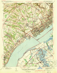
 1898 Philadelphia1898 Print · USGSPhiladelphia and Camden emerge as a Victorian-era industrial powerhouse at the turn of the century, knit together by ferry and rail. Researchers can trace ancestral roots in vanished neighborhoods like Paschallville or locate landmarks like the Alms House and Fort Mifflin.9 unique versions available
 - 1901 Map of Camden
 1901 Camden1901 Print · USGSThe Delaware River valley at the turn of the century shows a bustling corridor of early industrial growth and established mill towns. Researchers can trace the heritage of local industry at Sycamore Mills or locate early settlements like Penns Grove and Village Green.3 unique versions available
 - 1901 Map of West Chester, 1958 Print
 1901 West Chester1958 Print · USGSSettled hills and river valleys between Pennsylvania and Delaware are captured here in the early twentieth century. Trace the industrial landscape from West Chester down to Wilmington, finding landmarks like the Henry Clay Factory and Dutton Mill.
 - 1904 Map of West Chester
 1904 West Chester1904 Print · USGSChester County at the dawn of the 1900s reveals a thriving network of rail-connected villages and early industrial sites along the Brandywine Creek. Researchers can trace old family lands near Dutton Mill, the House of Refuge, and the vanished stops of the West Chester Br. railroad.8 unique versions available
 - 1920 Map of Philadelphia
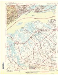
 1920 Philadelphia1920 Print · USGSPhiladelphia and its New Jersey neighbors are captured here just after the Great War, showing a landscape defined by massive riverfront industry and a dense rail network. Genealogists can trace family footprints through numerous small communities and stations like Blenheim Station, Woodbury Heights, and the grounds of the Alms House.
 - 1940 Map of Bridgeport
 1940 Bridgeport1940 Print · USGSThe industrial Delaware River waterfront and the rural truck farms of Gloucester County meet at the start of the 1940s. Researchers can trace family sites at Oaklawn Cem, follow the rail lines to Repaupo Sta, and see the footprint of the Locomotive Works.
 - 1941 Map of Marcus Hook
 1941 Marcus Hook1941 Print · USGSThe industrial and maritime riverfront at the start of the 1940s is captured here, showing the dense rail networks of the Marcus Hook area. Researchers can trace ancestral property near Hambys Corner, Siloam Ch, or the U S Military Reservation.
 - 1941 Map of Bridgeport
 1941 Bridgeport1941 Print · USGSThe Delaware River waterfront near Chester and Bridgeport was a hub of transit and industry in the early 1940s. Genealogists and historians can trace family locations through St Michael Cem, Oak Grove Sch, and the residential blocks of Westinghouse Village.
 - 1942 Map of Norristown
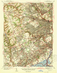
 1942 Norristown1942 Print · USGSSoutheastern Pennsylvania at the onset of World War II shows a landscape of busy industrial river towns and expanding rail suburbs. Genealogists and historians can trace the early transit networks connecting Norristown, Doylestown, and the riverfront at New Hope.
 - 1942 Map of Camden
 1942 Camden1942 Print · USGSThe Philadelphia and Camden metropolitan corridor is captured here at the height of the Second World War. Genealogists and historians can trace rail networks like the Reading R.R. and locate communities from Swedesboro to Merchantville.
 - 1942 Map of Lansdowne
 1942 Lansdowne1942 Print · USGSDelaware County townships thrive just before the mid-century, showing a landscape of dense residential growth and institutional landmarks. Genealogists can trace family sites near Holy Cross Cemetery or old rail hubs like Morton Sta and Lansdowne Sta.
 - 1943 Map of Philadelphia
 1943 Philadelphia1943 Print · USGSPhiladelphia and Camden are shown at their wartime peak, anchored by the industrial activity of the Delaware River waterfront. Genealogists and historians can trace rail-connected neighborhoods and landmarks like the U. S. Navy Yard, Fort Mifflin, and the Alms House.
 - 1943 Map of West Chester
 1943 West Chester1943 Print · USGSChester County during the early years of the war shows a landscape of established borough centers and winding creek valleys. Genealogists and historians can trace the rail-and-river network through West Chester, Brandywine Creek, and early industrial sites like Dutton Mill.
 - 1943 Map of Norristown
 1943 Norristown1943 Print · USGSMontgomery County in the early 1940s is a thriving network of rail-side industrial hubs and established borough centers. Genealogists and local historians can trace the development of Norristown and Lansdale or locate landmarks like the Eastern State Penitentiary.
 - 1944 Map of Bridgeport
 1944 Bridgeport1944 Print · USGSDuring the mid-1940s, the Delaware River waterfront between Pennsylvania and New Jersey served as a vital hub for manufacturing and transit. Genealogists and historians can locate family landmarks such as St Michael Cem, Oak Grove Sch, and industrial sites like the Locomotive Works.2 unique versions available
 - 1944 Map of Newark, 1971 Print
 1944 Newark1971 Print · USGSThe industrial corridor from Philadelphia to New York was in a period of massive transition during the mid-forties. Genealogists and researchers can trace the rail lines of the Lehigh Valley RR, locate military installations like Picatinny Arsenal, and explore the early sprawl near Levittown.5 unique versions available
Showing maps 1-25 of 95
Top cities of Delaware County
- Upper Darby historical maps
- Chester historical maps
- Radnor Township historical maps
- Marple Township historical maps
- Springfield Township historical maps
- Yeadon historical maps
See more
Frequently asked questions
- What are the different types of historical maps available for Delaware County?
- What is the oldest map of Delaware County?
- Where can I purchase historical maps of Delaware County for my home or office?
- Where can I download high-res historical maps of Delaware County?
- Are there historical topographic maps available for Delaware County?
- Is there historical aerial imagery available for Delaware County?
- Where are historical maps of Delaware County sourced from?