1950s Maps of Delaware County, Pennsylvania
Explore 14 historic maps of Delaware County from the 1950s. These maps offer a rare glimpse into what life looked like during the 1950s — showing old roads, neighborhoods, homes, and landmarks that have changed or disappeared over time.
Whether you're researching your family's past, planning a metal detecting trip, or studying how Delaware County's landscape evolved across the 1950s, these high-resolution maps are a powerful tool for exploring the history of this region.
- Focus on a specific era: All maps on this page are from the 1950s, giving you a focused view of this time period.
- See what’s changed: Compare century-old streets, trails, and buildings to today's modern landscape using overlays and satellite layers.
- Research with precision: Use these maps for genealogy, historical research, land use analysis, or educational projects.
- View, download, or print: Maps are fully viewable online in high resolution, and can be downloaded or printed for your own records.
Start exploring Delaware County's history through authentic maps from the 1950s. This is your window into the past.
Delaware County, PA maps
(14)- 1951 Map of Woodbury
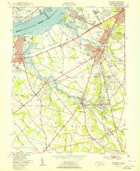 1951 Woodbury1951 Print · USGSGloucester County at the start of the fifties shows a landscape of busy rail corridors and riverfront industry. Trace the Pennsylvania-Reading Seashore Lines through Woodbury and locate the Hog Island Shipyard (Abandoned) or Fort Mifflin along the Delaware.
 - 1952 Map of Valley Forge, 1953 Print
 1952 Valley Forge1953 Print · USGSThe Main Line and Valley Forge area are captured here during the early fifties suburban expansion. Genealogists and researchers can trace local landmarks like Washington Memorial Chapel, the School for Blind, and the Norbertine Monastery.3 unique versions available
 - 1952 Map of Norristown, 1954 Print
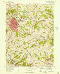
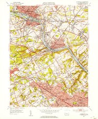 1952 Norristown1954 Print · USGSMontgomery County's river towns and Main Line colleges are captured in the early fifties during a period of rapid suburbanization. Trace the development of Villanova College and Bryn Mawr College or locate the old Patco Airport and Barbadoes Island.2 unique versions available
 - 1953 Map of Bridgeport, 1955 Print
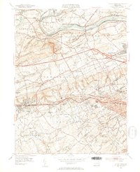
 1953 Bridgeport1955 Print · USGSThe industrial riverfront and tidal marshlands of the Delaware Valley are captured here in the early fifties during a period of significant coastal development. Researchers can trace the sprawling Pennsylvania Railroad network, institutional grounds like Crozier Seminary, and local landmarks from Thompson Point to Warrington Millpond.2 unique versions available
 - 1953 Map of Marcus Hook, 1956 Print
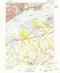
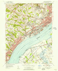 1953 Marcus Hook1956 Print · USGSThe industrial waterfront of the Delaware River comes alive in the early fifties, from the refineries of Marcus Hook to the busy streets of Chester. Trace family roots at Mt Hope Ch Cem or locate vanished landmarks like the U S Quarantine Sta and Tank Farm.2 unique versions available
 - 1954 Map of West Chester, 1956 Print
 1954 West Chester1956 Print · USGSSoutheast Pennsylvania's rolling hills are captured in the mid-1950s as suburban expansion begins to blend with traditional crossroads. Genealogists can locate family landmarks such as Brinton, Green Mount Cem, and the Dante Orphanage while tracing the winding path of Chester Creek.4 unique versions available
 - 1954 Map of Wilmington North, 1956 Print
 1954 Wilmington North1956 Print · USGSNorthern Delaware and the Pennsylvania borderlands appear here in the mid-fifties, dominated by the legendary estates and facilities of the Du Pont family. Genealogists and local historians can trace the development of Fairfax and Centerville or locate landmarks like Guyencourt and the Alfred I Du Pont Institute.2 unique versions available
 - 1955 Map of Wilmington
 1955 Wilmington1955 Print · USGSThe Delaware Valley and Jersey Shore are seen here during the mid-fifties era of rapid suburban expansion and highway development. You can trace the path of the New Jersey Turnpike, locate the Fort Dix Military Reservation, or explore the rail networks of the Pennsylvania Railroad.
 - 1955 Map of Media
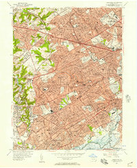
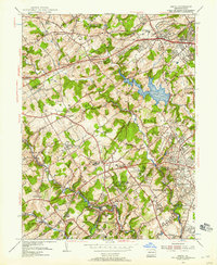 1955 Media1955 Print · USGSMid-century Delaware County was a landscape of significant private institutions and emerging suburbs just before the full suburban boom. Genealogists and researchers can trace local landmarks like Tyler Arboretum, the Williamson Trade School, and the historic rail junction at Wawa.2 unique versions available
 - 1956 Map of Newark
 1956 Newark1956 Print · USGSThe industrial heart of the Mid-Atlantic is captured here at the dawn of the highway era, tracing the dense corridors between Newark and Philadelphia. Genealogists and local historians can map the rail networks of the Reading RR or locate mid-century military life at Fort Dix Military Reservation.2 unique versions available
 - 1956 Map of Lansdowne, 1957 Print
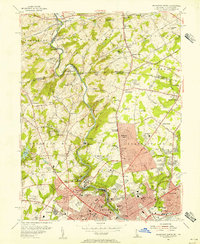
 1956 Lansdowne1957 Print · USGSEastern Delaware County was reaching its mid-century peak of suburban rail-and-road density in the 1950s. Researchers can trace historic property lines near Swarthmore College, locate ancestral sites in Holy Cross Cemetery, and follow the busy Pennsylvania Railroad corridor through Lansdowne and Darby.2 unique versions available
 - 1957 Map of Wilmington
 1957 Wilmington1957 Print · USGSThe mid-Atlantic coastal plain comes alive in the mid-fifties as the New Jersey Turnpike and Garden State Parkway redefine travel. Researchers can trace the rail-to-road transition and find landmarks like Ship John Shoal Light and the Fort Dix Military Reservation.2 unique versions available
 - 1957 Map of Newark
 1957 Newark1957 Print · USGSThe industrial and military heart of the Mid-Atlantic is mapped during its post-war suburban boom. Genealogists and historians can trace the intricate rail corridors of the Reading Railroad and locate key landmarks from Princeton University to Fort Hancock.
 - 1959 Map of Wilmington
 1959 Wilmington1959 Print · USGSThe Delaware Valley and Jersey Shore are seen here in the late fifties, during a period of massive suburban and highway expansion. Researchers can trace mid-century infrastructure like the N J Turnpike or locate coastal landmarks from Barnegat Bay to the Maurice River.3 unique versions available
End of results
Showing maps 1-14 of 14
Top cities of Delaware County
- Upper Darby historical maps
- Chester historical maps
- Radnor Township historical maps
- Marple Township historical maps
- Springfield Township historical maps
- Yeadon historical maps
See more
Frequently asked questions
- What are the different types of historical maps available for Delaware County?
- What is the oldest map of Delaware County?
- Where can I purchase historical maps of Delaware County for my home or office?
- Where can I download high-res historical maps of Delaware County?
- Are there historical topographic maps available for Delaware County?
- Is there historical aerial imagery available for Delaware County?
- Where are historical maps of Delaware County sourced from?