1900s (20th Century) Maps of Sheridan Corners, North East Township
Explore 10 historic maps of Sheridan Corners from the 1900s (20th Century). These maps offer a rare glimpse into what life looked like during the 1900s — showing old roads, neighborhoods, homes, and landmarks that have changed or disappeared over time.
Whether you're researching your family's past, planning a metal detecting trip, or studying how Sheridan Corners's landscape evolved across the 1900s, these high-resolution maps are a powerful tool for exploring the history of this region.
- Focus on a specific era: All maps on this page are from the 1900s, giving you a focused view of this time period.
- See what’s changed: Compare century-old streets, trails, and buildings to today's modern landscape using overlays and satellite layers.
- Research with precision: Use these maps for genealogy, historical research, land use analysis, or educational projects.
- View, download, or print: Maps are fully viewable online in high resolution, and can be downloaded or printed for your own records.
Start exploring Sheridan Corners's history through authentic maps from the 1900s. This is your window into the past.
Sheridan Corners, North East Township maps
(10)- 1913 Map of North East, 1962 Print
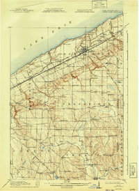
 1913 North East1962 Print · USGSThe Lake Erie shoreline and the Pennsylvania-New York border come alive in this survey of the pre-war lakefront and interior. Genealogists can locate dozens of early district schools and family landmarks like Colts Station, Lowville, and the McCord School.
 - 1915 Map of North East
 1915 North East1915 Print · USGSCoastal Erie County at the height of its early twentieth-century rail and fruit-growing era shows a landscape transitioning from bustling lake ports to quiet hilltop farmsteads. Genealogists can trace family connections through numerous rural schoolhouses and small hubs like Philipsville, Colts Station, and Moorheadville.5 unique versions available
 - 1943 Map of North East
 1943 North East1943 Print · USGSThe Lake Erie shoreline in the early 1940s reveals a landscape of productive orchards and lakeside communities at the Pennsylvania-New York border. Family historians can locate dozens of neighborhood schoolhouses and rural crossroads like Colts Station, Gospel Hill Sch, and Orchard Beach.
 - 1960 Map of Buffalo
 1960 Buffalo1960 Print · USGSWestern New York and the Niagara Peninsula thrive during the mid-twentieth century industrial peak. Genealogists and historians can trace family-named points and early settlements from Dunkirk Light to the Allegany Indian Reservation.
 - 1960 Map of Harborcreek, 1962 Print
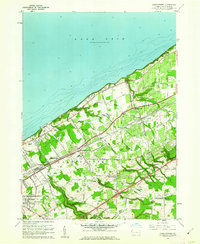 1960 Harborcreek1962 Print · USGSCoastal Erie County in the early sixties shows a landscape defined by Great Lakes commerce and suburban growth. Researchers can trace the dual rail lines through Harborcreek and locate historical sites like the Moorhead Air Park and St Gregory Cem.3 unique versions available
 - 1962 Map of Buffalo, 1980 Print
 1962 Buffalo1980 Print · USGSThe Niagara Frontier and Western New York are captured here in the early sixties, showing the vital industrial and maritime nexus between the U.S. and Canada. Researchers can trace the path of the Welland Canal, locate the Allegany Indian Reservation, or find family sites near Chautauqua Lake.2 unique versions available
 - 1967 Map of Buffalo
 1967 Buffalo1967 Print · USGSWestern New York and the Lake Erie shoreline are shown here during the mid-1960s industrial peak. Researchers can trace the massive rail networks of the Erie Railroad, locate the Cattaraugus Indian Reservation, or find historic sites like Fort Erie.
 - 1973 Map of Buffalo
 1973 Buffalo1973 Print · USGSWestern New York and Ontario's Golden Horseshoe meet in the early seventies, spanning from the industrial waterfronts of Buffalo to the hills of Allegany State Park. Trace the paths of the Welland Canal and Erie Lackawanna railroad through the lakefront towns of Dunkirk and Port Colborne.
 - 1986 Map of Jamestown
 1986 Jamestown1986 Print · USGSChautauqua County and the Lake Erie shoreline are captured in the mid-eighties as the region balanced its industrial rail hubs with lakeside culture. Local historians can trace the grounds of the Chautauqua Institution, the expansion of Jamestown, and rural landmarks like Sunset Hill Cemetery.2 unique versions available
 - 1996 Map of Harborcreek
 1996 Harborcreek1996 Print · USGSCoastal Erie County in the mid-nineties shows a landscape of established lakeside communities and ripening transit corridors. Researchers can trace family sites at St Gregory Cem, locate the Drive-in Theater, or study the rail networks of Conrail.
End of results
Showing maps 1-10 of 10
Top cities near Sheridan Corners
- Erie historical maps
- Harborcreek Township historical maps
- North East historical maps
- Lawrence Park Township historical maps
- Wesleyville historical maps
- Ripley historical maps
See more
Frequently asked questions
- What are the different types of historical maps available for Sheridan Corners?
- What is the oldest map of Sheridan Corners?
- Where can I purchase historical maps of Sheridan Corners for my home or office?
- Where can I download high-res historical maps of Sheridan Corners?
- Are there historical topographic maps available for Sheridan Corners?
- Is there historical aerial imagery available for Sheridan Corners?
- Where are historical maps of Sheridan Corners sourced from?