Old Maps of Belle Vernon, Fayette County for Metal Detecting
Plan your next treasure hunt with 16 historic maps of Belle Vernon. Find old homesites, ghost towns, trails, and gathering spots that may be lost to time — perfect for identifying promising metal detecting locations.
- Locate forgotten sites: Uncover places like long-lost settlements, abandoned rail lines, or gathering spots.
- Plan better hunts: Use map overlays combined with LiDAR or satellite views to narrow in on historically rich areas.
- Made for detectorists: Thousands of hobbyists use these maps to discover relics, coins, and hidden history.
Use these historic maps to boost your research and find new opportunities beneath the surface of Belle Vernon.
Belle Vernon, Fayette County maps
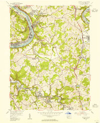
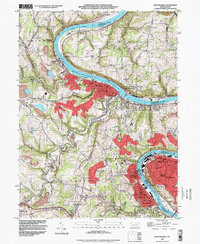
(16)- 1902 Map of Brownsville
 1902 Brownsville1902 Print · USGSCovers Belle Vernon, including Monessen, California, and other nearby areas
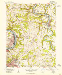
 - 1906 Map of Brownsville
 1906 Brownsville1906 Print · USGSCovers Belle Vernon, including Monessen, California, and other nearby areas4 unique versions available
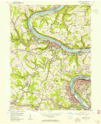
 - 1931 Map of Brownsville, 1954 Print
 1931 Brownsville1954 Print · USGSCovers Belle Vernon, including Monessen, California, and other nearby areas
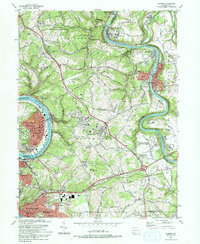
 - 1933 Map of Brownsville
 1933 Brownsville1933 Print · USGSCovers Belle Vernon, including Monessen, California, and other nearby areas2 unique versions available
 - 1940 Map of Brownsville
 1940 Brownsville1940 Print · USGSCovers Belle Vernon, including Monessen, California, and other nearby areas
 - 1953 Map of Pittsburgh
 1953 Pittsburgh1953 Print · USGSCovers Belle Vernon, including Pittsburgh, Penn Hills, and other nearby areas
 - 1954 Map of Pittsburgh
 1954 Pittsburgh1954 Print · USGSCovers Belle Vernon, including Pittsburgh, Penn Hills, and other nearby areas2 unique versions available
 - 1954 Map of Fayette City, 1955 Print
 1954 Fayette City1955 Print · USGSCovers Belle Vernon, including Redstone, Perryopolis, and other nearby areas3 unique versions available
 - 1954 Map of Donora, 1955 Print
 1954 Donora1955 Print · USGSCovers Belle Vernon, including Monessen, Donora, and other nearby areas4 unique versions available
 - 1954 Map of Monongahela, 1955 Print
 1954 Monongahela1955 Print · USGSCovers Belle Vernon, including Monessen, Charleroi, and other nearby areas4 unique versions available
 - 1958 Map of Pittsburgh
 1958 Pittsburgh1958 Print · USGSCovers Belle Vernon, including Pittsburgh, Penn Hills, and other nearby areas5 unique versions available
 - 1959 Map of Pittsburgh
 1959 Pittsburgh1959 Print · USGSCovers Belle Vernon, including Pittsburgh, Penn Hills, and other nearby areas
 - 1964 Map of Pittsburgh
 1964 Pittsburgh1964 Print · USGSCovers Belle Vernon, including Pittsburgh, Penn Hills, and other nearby areas
 - 1986 Map of Pittsburgh East
 1986 Pittsburgh East1986 Print · USGSCovers Belle Vernon, including Pittsburgh, Penn Hills, and other nearby areas3 unique versions available
 - 1993 Map of Donora
 1993 Donora1993 Print · USGSCovers Belle Vernon, including Monessen, Donora, and other nearby areas2 unique versions available
 - 1993 Map of Monongahela, 1999 Print
 1993 Monongahela1999 Print · USGSCovers Belle Vernon, including Monessen, Charleroi, and other nearby areas
End of results
Showing maps 1-16 of 16
Frequently asked questions
- What are the different types of historical maps available for Belle Vernon?
- What is the oldest map of Belle Vernon?
- Where can I purchase historical maps of Belle Vernon for my home or office?
- Where can I download high-res historical maps of Belle Vernon?
- Are there historical topographic maps available for Belle Vernon?
- Is there historical aerial imagery available for Belle Vernon?
- Where are historical maps of Belle Vernon sourced from?