Old Maps of Fayette County, Pennsylvania
Explore 140 old maps of Fayette County, spanning from 1900 to today. These high-resolution historic maps reveal how streets, neighborhoods, landmarks, and natural features evolved over time — perfect for genealogy, metal detecting, research, and local history exploration.
What you can do with these maps:
- See how Fayette County changed over time: Compare historical maps to modern-day views to trace roads, homesites, rail lines & more.
- View detailed metadata: Each map includes creators, publishers, year, scale, and archive source.
- Overlay maps with satellite & LiDAR: Visualize the past alongside modern tools to explore terrain & human change.
- Trusted historical sources: Maps sourced from the USGS, Library of Congress, and other archives.
- Access maps your way: View online, download high-res files, or order prints for personal or research use.
Start exploring old maps of Fayette County to uncover forgotten places, hidden landmarks, and the deep history beneath your feet.
Fayette County, PA maps
(140)- 1900 Map of Accident
 1900 Accident1900 Print · USGSGarrett County highlands at the turn of the century reveal a landscape of mountain settlements and river-valley industry. Genealogists can trace family roots through the Blooming Rose Settlement, early milling sites like Speelman Mills, and the Baltimore and Ohio RR corridor.6 unique versions available
 - 1900 Map of Uniontown
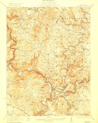
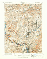
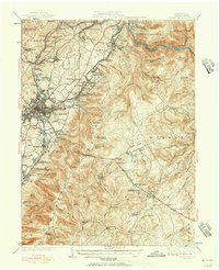
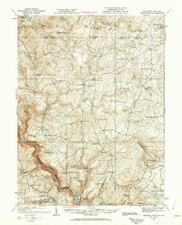
 1900 Uniontown1900 Print · USGSFayette County at the turn of the century shows a landscape defined by the iron and coal industries and early American frontier history. Researchers can locate significant sites like Fort Necessity, Braddocks Grave, and the path of the National Pike.5 unique versions available
 - 1900 Map of Masontown
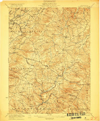
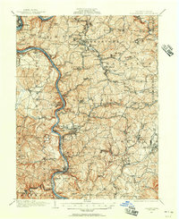
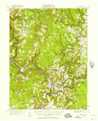
 1900 Masontown1900 Print · USGSThe Monongahela River valley was a hub of transit and industry at the turn of the century, defined by its numerous ferry crossings and coal-country junctions. Researchers can trace historic river crossings like McCanns Ferry, follow the National Pike, and locate vanished rail stops at Ache Junction.
 - 1901 Map of Waynesburg, 1958 Print
 1901 Waynesburg1958 Print · USGSGreene County at the start of the twentieth century shows a landscape of deep valleys and rising townships connected by the South Fork of Tenmile Creek. Genealogists can trace family names through landmarks like Rees Mill, Gump, and the dual settlement of Kirby Newtown.
 - 1902 Map of Brownsville
 1902 Brownsville1902 Print · USGSThe Monongahela Valley was a powerhouse of Pennsylvania industry at the start of the twentieth century, defined by its coal mines and river-front rail lines. Researchers can trace the heritage of the National Pike and locate vanished works at Vesta Mine or Coal Bluff.
 - 1902 Map of Morgantown
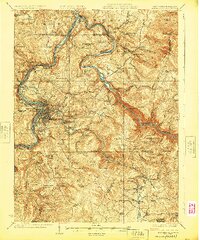
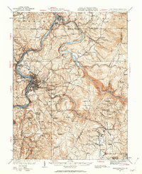
 1902 Morgantown1902 Print · USGSMorgantown and the Monongahela River corridor appear here at the dawn of the twentieth century, captured during a period of industrial growth. Genealogists and historians can trace old iron industry sites like Clinton Furnace, river crossings at Ice's Ferry, and early rail routes.5 unique versions available
 - 1902 Map of Connellsville
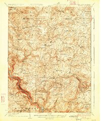
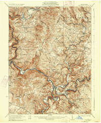
 1902 Connellsville1902 Print · USGSThe Pennsylvania coke region comes alive at the turn of the century as a labyrinth of coal mines and competing rail lines. Researchers can trace the industrial footprint of Star Mines, explore the river landings along the Youghiogheny River, and find old junctions like Bells Mills.5 unique versions available
 - 1903 Map of Masontown
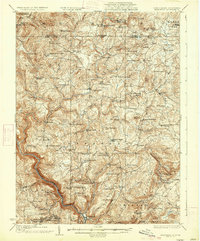
 1903 Masontown1903 Print · USGSThe Monongahela River valley at the turn of the century was a vital artery of ferries and river locks connecting Fayette and Greene Counties. Genealogists and local historians can trace family roots through riverfront landings and towns like Greensboro, Masontown, and Smithfield.4 unique versions available
 - 1904 Map of Bruceton
 1904 Bruceton1904 Print · USGSPreston County was a landscape of mountain ridges and milling hamlets shortly after the turn of the century. Genealogists can trace family roots through upland settlements like Clifton Mills, Hazelton, and the rural Cuzzart P.O.3 unique versions available
 - 1904 Map of Waynesburg
 1904 Waynesburg1904 Print · USGSGreene County was a landscape of deeply carved creek valleys and rural crossroads at the start of the twentieth century. Genealogists and local historians can trace early property settings near Waynesburg, Rees Mill, and the riverside borough of Rices Landing.5 unique versions available
 - 1906 Map of Brownsville
 1906 Brownsville1906 Print · USGSSouthwestern Pennsylvania’s river valleys were centers of industrial expansion when this survey was conducted. Genealogists can locate family homes and landmarks in riverfront towns like Monessen and Charleroi, or trace rural roots near Salem Church and Ginger Hill.4 unique versions available
 - 1922 Map of Confluence
 1922 Confluence1922 Print · USGSThe confluence of the Youghiogheny River and Casselman River was a major rail and river hub in the 1920s. Genealogists and local historians can trace the foundations of many small settlements and mountain schools, from Ohiopyle to the Baldwin Mine and Wesley Chapel.3 unique versions available
 - 1922 Map of Donegal
 1922 Donegal1922 Print · USGSWestmoreland and Fayette counties are captured here in the early twenties, showing a landscape of mountain ridges and busy valley crossroads. Genealogists can trace family roots through dozens of rural landmarks like St Boniface Chapel, Hoods Mill, and the Snowball School.2 unique versions available
 - 1925 Map of Morgantown
 1925 Morgantown1925 Print · USGSMorgantown and the Monongahela River valley are shown in the mid-1920s as industrial rail corridors and mountain settlements expanded. Trace old family schoolhouses, mining-era rail stops at Dellslow Sta, and the historic Laurel Iron Works near the Cheat River.2 unique versions available
 - 1926 Map of Bruceton
 1926 Bruceton1926 Print · USGSPreston County and the Pennsylvania borderlands are captured here in the mid-twenties, a time when mountain life was centered on rural mills and schools. Genealogists can trace family footprints at Old Brick Church, Clifton Mills, and the Gaflisch Mine.2 unique versions available
 - 1931 Map of Brownsville, 1954 Print
 1931 Brownsville1954 Print · USGSThe industrial Monongahela and Youghiogheny river valleys are captured here in the early thirties, showcasing a landscape of coal mines and river locks. Genealogists can trace family homes near Vesta Mine, Sutersville, and rural landmarks like Salem Church.
 - 1931 Map of Connellsville, 1954 Print
 1931 Connellsville1954 Print · USGSSouthwestern Pennsylvania's coal and rail heartland is meticulously detailed here in the early thirties. Local researchers can trace the industrial footprint of Star Mines, the sprawling rail yards of Connellsville, and rural landmarks like Bryner Ch and Mud Sch.2 unique versions available
 - 1931 Map of Uniontown, 1956 Print
 1931 Uniontown1956 Print · USGSFayette County is captured in the early 1930s during a period of transition for its mountain communities and industrial furnace towns. Genealogists can trace family roots at Sylvan Heights Cem or locate the rural Hughes Sch and Wharton Furnace.2 unique versions available
 - 1931 Map of Masontown, 1957 Print
 1931 Masontown1957 Print · USGSFayette County’s industrial landscape is captured here during the 1930s, showing the high-water mark of the regional coal and coke era. Genealogists and historians can trace company towns and numbered mines like Tower Hill No 1 and Thompson No 2 alongside river crossings like Crows Ferry.
 - 1931 Map of Confluence, 1958 Print
 1931 Confluence1958 Print · USGSThe Laurel Highlands at the start of the 1930s reveal a landscape of deep river valleys and high ridges defined by coal mining and heavy rail. Genealogists can trace family names through dozens of rural sites like Sands Church, Somerfield, and the Mary Ann Mine.2 unique versions available
 - 1931 Map of Bruceton Mills, 1962 Print
 1931 Bruceton Mills1962 Print · USGSNorthern Preston County and the Pennsylvania border are shown in the 1930s as a landscape of rural mills and mountain schools. Genealogists can locate family names at Glade Farms, Clifton Mills, and the Old Brick Church.
 - 1931 Map of Morgantown, 1962 Print
 1931 Morgantown1962 Print · USGSMorgantown and the Monongahela River valley are shown here during the early twentieth-century peak of the regional rail-and-river economy. Genealogists can trace family names through numerous rural landmarks like Lazzell School, Burns Chapel, and Clinton Furnace.
 - 1933 Map of Brownsville
 1933 Brownsville1933 Print · USGSWestern Pennsylvania’s industrial heartland thrives along the river bends in the early thirties, where coal and rail define the landscape. Trace the expansion of river towns like Charleroi and Monessen, locate the Vesta Mine, or find rural landmarks like Mt Union Sch.2 unique versions available
 - 1933 Map of Confluence
 1933 Confluence1933 Print · USGSThe Laurel Highlands during the early 1930s come into focus through the river networks of Fayette and Somerset counties. Trace family roots at Paddytown or Somerfield, and locate long-gone schoolhouses such as Clay Run School and the Mary Ann Mine.2 unique versions available
 - 1933 Map of Bruceton
 1933 Bruceton1933 Print · USGSPreston County and the Pennsylvania borderlands are shown here in the early 1930s, defined by a deep-rooted network of rural schools and milling sites. Researchers can trace family history through dozens of local landmarks like Clifton Mills, the Old Brick Church, and Caflisch Mine.3 unique versions available
Showing maps 1-25 of 140
Top cities of Fayette County
- Uniontown historical maps
- Connellsville historical maps
- Luzerne Township historical maps
- Masontown historical maps
- Springhill Township historical maps
- South Connellsville historical maps
See more
Frequently asked questions
- What are the different types of historical maps available for Fayette County?
- What is the oldest map of Fayette County?
- Where can I purchase historical maps of Fayette County for my home or office?
- Where can I download high-res historical maps of Fayette County?
- Are there historical topographic maps available for Fayette County?
- Is there historical aerial imagery available for Fayette County?
- Where are historical maps of Fayette County sourced from?