1940s Maps of Fayette County, Pennsylvania
Explore 6 historic maps of Fayette County from the 1940s. These maps offer a rare glimpse into what life looked like during the 1940s — showing old roads, neighborhoods, homes, and landmarks that have changed or disappeared over time.
Whether you're researching your family's past, planning a metal detecting trip, or studying how Fayette County's landscape evolved across the 1940s, these high-resolution maps are a powerful tool for exploring the history of this region.
- Focus on a specific era: All maps on this page are from the 1940s, giving you a focused view of this time period.
- See what’s changed: Compare century-old streets, trails, and buildings to today's modern landscape using overlays and satellite layers.
- Research with precision: Use these maps for genealogy, historical research, land use analysis, or educational projects.
- View, download, or print: Maps are fully viewable online in high resolution, and can be downloaded or printed for your own records.
Start exploring Fayette County's history through authentic maps from the 1940s. This is your window into the past.
Fayette County, PA maps
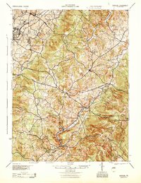
(6)- 1940 Map of Brownsville
 1940 Brownsville1940 Print · USGSThe Monongahela and Youghiogheny river valleys were the industrial heart of Pennsylvania during this era of coal and steel. Genealogists and historians can trace the exact locations of Vesta Mine, Salem Church, and historic rural schools like Central Sch.
 - 1944 Map of Donegal, 1945 Print
 1944 Donegal1945 Print · USGSWestmoreland and Fayette Counties are shown in the 1940s just as the Pennsylvania Turnpike was changing the landscape. Genealogists and historians can trace dozens of rural schools and churches, from Stauffer Sch to St Boniface Chapel.
 - 1947 Map of Friendsville, 1965 Print
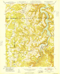
 1947 Friendsville1965 Print · USGSMaryland's mountainous panhandle meets Pennsylvania and West Virginia in this mid-century study of the Youghiogheny valley. Genealogists can locate family landmarks like Thomas Cemetery and Emberson Cemetery, or rural schoolhouses like McCabe School.6 unique versions available
 - 1948 Map of Cumberland
 1948 Cumberland1948 Print · USGSMid-century Appalachia and the Shenandoah Valley are shown in detail, documenting the industrial and transportation hubs of the tri-state area. Genealogists can trace family roots through settlements like Double Tollgate and Bunker Hill or along the Baltimore & Ohio RR.3 unique versions available
 - 1949 Map of Friendsville
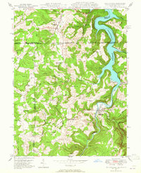
 1949 Friendsville1949 Print · USGSThe tri-state borderlands of Maryland, Pennsylvania, and West Virginia appear here in the late 1940s, centered on the growing Youghiogheny Reservoir. Genealogists and historians can trace family landmarks along the Mason And Dixon Line, from Thomas Cem to the early roads of Friendsville.
 - 1949 Map of Clarksburg
 1949 Clarksburg1949 Print · USGSThe upper Ohio River valley and the industrial heart of West Virginia come into focus during this post-war period. Genealogists and researchers can trace the rail corridors of the Baltimore and Ohio and locate centers like Fairmont, Grafton, and Waynesburg.
End of results
Showing maps 1-6 of 6
Top cities of Fayette County
- Uniontown historical maps
- Connellsville historical maps
- Luzerne Township historical maps
- Masontown historical maps
- Springhill Township historical maps
- South Connellsville historical maps
See more
Frequently asked questions
- What are the different types of historical maps available for Fayette County?
- What is the oldest map of Fayette County?
- Where can I purchase historical maps of Fayette County for my home or office?
- Where can I download high-res historical maps of Fayette County?
- Are there historical topographic maps available for Fayette County?
- Is there historical aerial imagery available for Fayette County?
- Where are historical maps of Fayette County sourced from?