1930s Maps of Fayette County, Pennsylvania
Explore 15 historic maps of Fayette County from the 1930s. These maps offer a rare glimpse into what life looked like during the 1930s — showing old roads, neighborhoods, homes, and landmarks that have changed or disappeared over time.
Whether you're researching your family's past, planning a metal detecting trip, or studying how Fayette County's landscape evolved across the 1930s, these high-resolution maps are a powerful tool for exploring the history of this region.
- Focus on a specific era: All maps on this page are from the 1930s, giving you a focused view of this time period.
- See what’s changed: Compare century-old streets, trails, and buildings to today's modern landscape using overlays and satellite layers.
- Research with precision: Use these maps for genealogy, historical research, land use analysis, or educational projects.
- View, download, or print: Maps are fully viewable online in high resolution, and can be downloaded or printed for your own records.
Start exploring Fayette County's history through authentic maps from the 1930s. This is your window into the past.
Fayette County, PA maps
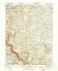
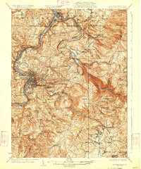
(15)- 1931 Map of Brownsville, 1954 Print
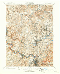
 1931 Brownsville1954 Print · USGSThe industrial Monongahela and Youghiogheny river valleys are captured here in the early thirties, showcasing a landscape of coal mines and river locks. Genealogists can trace family homes near Vesta Mine, Sutersville, and rural landmarks like Salem Church.
 - 1931 Map of Connellsville, 1954 Print
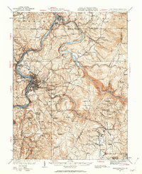
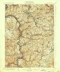
 1931 Connellsville1954 Print · USGSSouthwestern Pennsylvania's coal and rail heartland is meticulously detailed here in the early thirties. Local researchers can trace the industrial footprint of Star Mines, the sprawling rail yards of Connellsville, and rural landmarks like Bryner Ch and Mud Sch.2 unique versions available
 - 1931 Map of Uniontown, 1956 Print
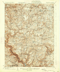
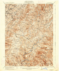
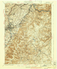
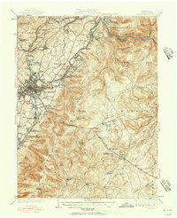 1931 Uniontown1956 Print · USGSFayette County is captured in the early 1930s during a period of transition for its mountain communities and industrial furnace towns. Genealogists can trace family roots at Sylvan Heights Cem or locate the rural Hughes Sch and Wharton Furnace.2 unique versions available
 - 1931 Map of Masontown, 1957 Print
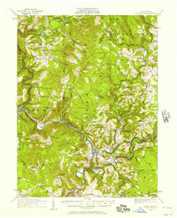
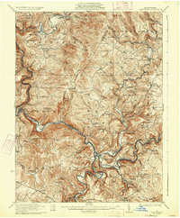
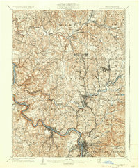
 1931 Masontown1957 Print · USGSFayette County’s industrial landscape is captured here during the 1930s, showing the high-water mark of the regional coal and coke era. Genealogists and historians can trace company towns and numbered mines like Tower Hill No 1 and Thompson No 2 alongside river crossings like Crows Ferry.
 - 1931 Map of Confluence, 1958 Print
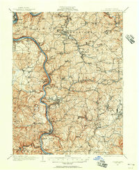
 1931 Confluence1958 Print · USGSThe Laurel Highlands at the start of the 1930s reveal a landscape of deep river valleys and high ridges defined by coal mining and heavy rail. Genealogists can trace family names through dozens of rural sites like Sands Church, Somerfield, and the Mary Ann Mine.2 unique versions available
 - 1931 Map of Bruceton Mills, 1962 Print
 1931 Bruceton Mills1962 Print · USGSNorthern Preston County and the Pennsylvania border are shown in the 1930s as a landscape of rural mills and mountain schools. Genealogists can locate family names at Glade Farms, Clifton Mills, and the Old Brick Church.
 - 1931 Map of Morgantown, 1962 Print
 1931 Morgantown1962 Print · USGSMorgantown and the Monongahela River valley are shown here during the early twentieth-century peak of the regional rail-and-river economy. Genealogists can trace family names through numerous rural landmarks like Lazzell School, Burns Chapel, and Clinton Furnace.
 - 1933 Map of Brownsville
 1933 Brownsville1933 Print · USGSWestern Pennsylvania’s industrial heartland thrives along the river bends in the early thirties, where coal and rail define the landscape. Trace the expansion of river towns like Charleroi and Monessen, locate the Vesta Mine, or find rural landmarks like Mt Union Sch.2 unique versions available
 - 1933 Map of Confluence
 1933 Confluence1933 Print · USGSThe Laurel Highlands during the early 1930s come into focus through the river networks of Fayette and Somerset counties. Trace family roots at Paddytown or Somerfield, and locate long-gone schoolhouses such as Clay Run School and the Mary Ann Mine.2 unique versions available
 - 1933 Map of Bruceton
 1933 Bruceton1933 Print · USGSPreston County and the Pennsylvania borderlands are shown here in the early 1930s, defined by a deep-rooted network of rural schools and milling sites. Researchers can trace family history through dozens of local landmarks like Clifton Mills, the Old Brick Church, and Caflisch Mine.3 unique versions available
 - 1933 Map of Morgantown
 1933 Morgantown1933 Print · USGSMorgantown and the surrounding Monongalia County river valleys are captured here in the early 1930s during a period of industrial maturity. Genealogists and historians can trace family locations near Clinton Furnace, Maidsville PO and Sta, and McClure Chapel.3 unique versions available
 - 1935 Map of Masontown
 1935 Masontown1935 Print · USGSFayette and Greene Counties come alive in the 1930s as the river-and-rail economy of the Monongahela Valley reaches its peak. Genealogists can trace family roots through numerous country schools like Christopher Sch and historic sites such as Friendship Hill.2 unique versions available
 - 1935 Map of Donegal
 1935 Donegal1935 Print · USGSWestmoreland County communities are shown here in the 1930s, as coal towns and rural hamlets relied on a network of mountain rail lines and country schools. Genealogists can trace family roots through numerous sites like Stahlstown, the Mansville Post Office, and St Boniface Chapel.2 unique versions available
 - 1936 Map of Connellsville
 1936 Connellsville1936 Print · USGSSouthwestern Pennsylvania during the mid-1930s reveals a landscape of industrial power and rural community along the Youghiogheny River. Genealogists and historians can trace family roots through numerous named schools like Jefferson Sch and Gault Sch, or locate former industrial hubs at Star Mines and the Fairgrounds.3 unique versions available
 - 1939 Map of Uniontown
 1939 Uniontown1939 Print · USGSFayette County was a powerhouse of industry and history during the 1930s. Genealogists and historians can trace the coke ovens and colliery towns from Juniatta Ovens to Lemont Furnace, or locate the Fort Necessity Battlefield Site.2 unique versions available
End of results
Showing maps 1-15 of 15
Top cities of Fayette County
- Uniontown historical maps
- Connellsville historical maps
- Luzerne Township historical maps
- Masontown historical maps
- Springhill Township historical maps
- South Connellsville historical maps
See more
Frequently asked questions
- What are the different types of historical maps available for Fayette County?
- What is the oldest map of Fayette County?
- Where can I purchase historical maps of Fayette County for my home or office?
- Where can I download high-res historical maps of Fayette County?
- Are there historical topographic maps available for Fayette County?
- Is there historical aerial imagery available for Fayette County?
- Where are historical maps of Fayette County sourced from?