1920s Maps of Fayette County, Pennsylvania
Explore 4 historic maps of Fayette County from the 1920s. These maps offer a rare glimpse into what life looked like during the 1920s — showing old roads, neighborhoods, homes, and landmarks that have changed or disappeared over time.
Whether you're researching your family's past, planning a metal detecting trip, or studying how Fayette County's landscape evolved across the 1920s, these high-resolution maps are a powerful tool for exploring the history of this region.
- Focus on a specific era: All maps on this page are from the 1920s, giving you a focused view of this time period.
- See what’s changed: Compare century-old streets, trails, and buildings to today's modern landscape using overlays and satellite layers.
- Research with precision: Use these maps for genealogy, historical research, land use analysis, or educational projects.
- View, download, or print: Maps are fully viewable online in high resolution, and can be downloaded or printed for your own records.
Start exploring Fayette County's history through authentic maps from the 1920s. This is your window into the past.
Fayette County, PA maps
(4)- 1922 Map of Confluence
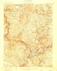 1922 Confluence1922 Print · USGSThe confluence of the Youghiogheny River and Casselman River was a major rail and river hub in the 1920s. Genealogists and local historians can trace the foundations of many small settlements and mountain schools, from Ohiopyle to the Baldwin Mine and Wesley Chapel.3 unique versions available
 - 1922 Map of Donegal
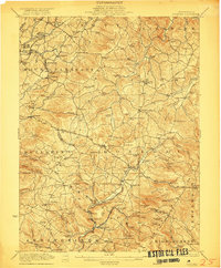 1922 Donegal1922 Print · USGSWestmoreland and Fayette counties are captured here in the early twenties, showing a landscape of mountain ridges and busy valley crossroads. Genealogists can trace family roots through dozens of rural landmarks like St Boniface Chapel, Hoods Mill, and the Snowball School.2 unique versions available
 - 1925 Map of Morgantown
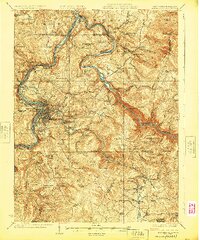 1925 Morgantown1925 Print · USGSMorgantown and the Monongahela River valley are shown in the mid-1920s as industrial rail corridors and mountain settlements expanded. Trace old family schoolhouses, mining-era rail stops at Dellslow Sta, and the historic Laurel Iron Works near the Cheat River.2 unique versions available
 - 1926 Map of Bruceton
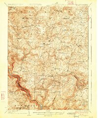 1926 Bruceton1926 Print · USGSPreston County and the Pennsylvania borderlands are captured here in the mid-twenties, a time when mountain life was centered on rural mills and schools. Genealogists can trace family footprints at Old Brick Church, Clifton Mills, and the Gaflisch Mine.2 unique versions available
End of results
Showing maps 1-4 of 4
Top cities of Fayette County
- Uniontown historical maps
- Connellsville historical maps
- Luzerne Township historical maps
- Masontown historical maps
- Springhill Township historical maps
- South Connellsville historical maps
See more
Frequently asked questions
- What are the different types of historical maps available for Fayette County?
- What is the oldest map of Fayette County?
- Where can I purchase historical maps of Fayette County for my home or office?
- Where can I download high-res historical maps of Fayette County?
- Are there historical topographic maps available for Fayette County?
- Is there historical aerial imagery available for Fayette County?
- Where are historical maps of Fayette County sourced from?