1950s Maps of Fayette County, Pennsylvania
Explore 16 historic maps of Fayette County from the 1950s. These maps offer a rare glimpse into what life looked like during the 1950s — showing old roads, neighborhoods, homes, and landmarks that have changed or disappeared over time.
Whether you're researching your family's past, planning a metal detecting trip, or studying how Fayette County's landscape evolved across the 1950s, these high-resolution maps are a powerful tool for exploring the history of this region.
- Focus on a specific era: All maps on this page are from the 1950s, giving you a focused view of this time period.
- See what’s changed: Compare century-old streets, trails, and buildings to today's modern landscape using overlays and satellite layers.
- Research with precision: Use these maps for genealogy, historical research, land use analysis, or educational projects.
- View, download, or print: Maps are fully viewable online in high resolution, and can be downloaded or printed for your own records.
Start exploring Fayette County's history through authentic maps from the 1950s. This is your window into the past.
Fayette County, PA maps
(16)- 1952 Map of Cumberland
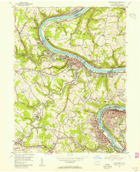
 1952 Cumberland1952 Print · USGSThe Potomac Highlands and the Shenandoah Valley are revealed in this early 1950s survey of the Appalachian interior. Researchers can trace the river-and-rail corridors connecting Cumberland, Winchester, and the recreational waters of Deep Creek Lake.
 - 1953 Map of Pittsburgh
 1953 Pittsburgh1953 Print · USGSWestern Pennsylvania's industrial landscape at the start of the fifties shows the steel and rail corridors between Pittsburgh and Altoona. Trace family roots in river towns like Tarentum or follow the Pennsylvania Turnpike across Laurel Hill.
 - 1954 Map of Pittsburgh
 1954 Pittsburgh1954 Print · USGSWestern Pennsylvania in the early fifties remains a powerhouse of heavy industry and vital transit corridors. Genealogists and historians can trace the rail-and-river network connecting Pittsburgh, Johnstown, and Altoona via the Pennsylvania RR and the Lincoln Highway.2 unique versions available
 - 1954 Map of California, 1955 Print
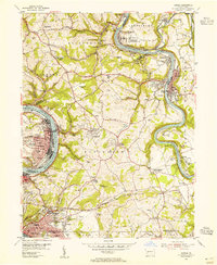
 1954 California1955 Print · USGSThe Monongahela river valley and the historic coal country of Washington County are shown here in the mid-fifties. Researchers can trace the industrial footprint of Vesta No 6 Mine, locate the campus of State Teachers College, or find family landmarks like Maple Creek Cem.3 unique versions available
 - 1954 Map of Smithton, 1955 Print
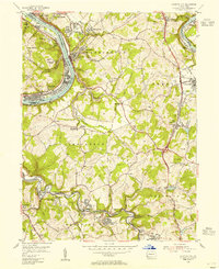
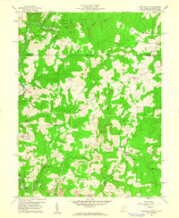
 1954 Smithton1955 Print · USGSWestmoreland County at the height of its mid-century mining era shows a landscape of busy coal towns and river-fed industry. Genealogists can trace family roots through numerous local landmarks like St Timothys Cem, Cameron Sch, and the Hough Fricano Mine No 1 (Active).4 unique versions available
 - 1954 Map of Fayette City, 1955 Print
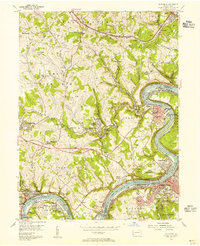
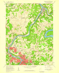
 1954 Fayette City1955 Print · USGSThe industrial river valleys of Fayette and Washington counties come alive in the mid-fifties. Trace family roots and coal history through Fayette City, Rowes Run, and old landmarks like Little Redstone Ch and the Colonial Dock.3 unique versions available
 - 1954 Map of Donora, 1955 Print
 1954 Donora1955 Print · USGSThe industrial heart of the Monongahela and Youghiogheny valleys is captured here during the mid-fifties. Researchers can trace coal operations at Ocean Mine and Coal Hollow Mine or locate family roots at Concord Pioneer Sch.4 unique versions available
 - 1954 Map of Monongahela, 1955 Print
 1954 Monongahela1955 Print · USGSIndustrial life along the river valley is captured here in the mid-fifties, showing the deep integration of coal mining and rail transport. Researchers can locate family landmarks from the Black Diamond Mine to the Mentor School and Ohav Sholom Cem.4 unique versions available
 - 1956 Map of Cumberland, 1966 Print
 1956 Cumberland1966 Print · USGSThe tri-state Highlands in the mid-1950s show a landscape shaped by coal, timber, and the massive presence of the Baltimore & Ohio RR. Researchers can trace the industrial corridor from Cumberland through the Allegheny Mountains to mountain retreats like Deep Creek Lake.6 unique versions available
 - 1956 Map of Clarksburg, 1966 Print
 1956 Clarksburg1966 Print · USGSThe Ohio River valley and the industrial heart of West Virginia are seen here in the mid-1950s as rail and river commerce thrived. Researchers can trace historic transport lines like the Baltimore and Ohio RR and locate ancestral homes in Clarksburg, Moundsville, or Parkersburg.2 unique versions available
 - 1957 Map of Donegal
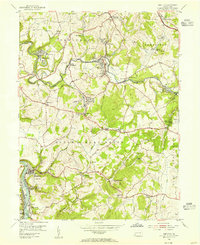
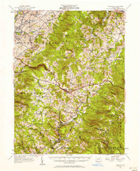 1957 Donegal1957 Print · USGSWestmoreland and Fayette counties are captured here in the late fifties, showing the rural communities along the western slopes of the Laurel Highlands. Genealogists can trace family roots through numerous local landmarks like Norvelt, the Baltimore and Ohio rail line, and the many rural schools including Hurst High School.2 unique versions available
 - 1957 Map of Cumberland
 1957 Cumberland1957 Print · USGSThe Potomac River valley and the ridges of the Allegheny Front define this mid-century landscape at the intersection of Maryland, West Virginia, and Pennsylvania. Trace the steam-era rail lines of the Baltimore and Ohio RR or locate rural landmarks like St Stephens Church and Stony River Dam.
 - 1957 Map of Morgantown North, 1959 Print
 1957 Morgantown North1959 Print · USGSMonongalia County's river-and-rail economy is in full view during the late fifties, showing the growth of Morgantown and its industrial satellites. Genealogists and historians can trace family roots through Taylortown and Bertha Hill, or locate institutions like West Virginia University.4 unique versions available
 - 1958 Map of Pittsburgh
 1958 Pittsburgh1958 Print · USGSWestern Pennsylvania in the late fifties shows an industrial heartland defined by the confluence of the Allegheny River and Monongahela River. Researchers can trace the sprawling rail networks of the Pennsylvania RR and find established towns like Butler, Latrobe, and Windber.5 unique versions available
 - 1959 Map of Pittsburgh
 1959 Pittsburgh1959 Print · USGSWestern Pennsylvania in the late fifties is captured here at the height of its industrial era. Genealogists and historians can trace the riverfront growth of Pittsburgh, the rail works at Altoona, and the mountain gaps of Laurel Hill.
 - 1959 Map of Brandonville, 1960 Print
 1959 Brandonville1960 Print · USGSThe West Virginia-Pennsylvania borderlands are captured here during the late fifties, showing the rural communities of Preston County. Genealogists can trace family names through landmarks like Teets Cem, Salem Sch, and the numerous coal Strip Mine sites near Brandonville.6 unique versions available
End of results
Showing maps 1-16 of 16
Top cities of Fayette County
- Uniontown historical maps
- Connellsville historical maps
- Luzerne Township historical maps
- Masontown historical maps
- Springhill Township historical maps
- South Connellsville historical maps
See more
Frequently asked questions
- What are the different types of historical maps available for Fayette County?
- What is the oldest map of Fayette County?
- Where can I purchase historical maps of Fayette County for my home or office?
- Where can I download high-res historical maps of Fayette County?
- Are there historical topographic maps available for Fayette County?
- Is there historical aerial imagery available for Fayette County?
- Where are historical maps of Fayette County sourced from?