1960s Maps of Barnett Township, Pennsylvania
Explore 4 historic maps of Barnett Township from the 1960s. These maps offer a rare glimpse into what life looked like during the 1960s — showing old roads, neighborhoods, homes, and landmarks that have changed or disappeared over time.
Whether you're researching your family's past, planning a metal detecting trip, or studying how Barnett Township's landscape evolved across the 1960s, these high-resolution maps are a powerful tool for exploring the history of this region.
- Focus on a specific era: All maps on this page are from the 1960s, giving you a focused view of this time period.
- See what’s changed: Compare century-old streets, trails, and buildings to today's modern landscape using overlays and satellite layers.
- Research with precision: Use these maps for genealogy, historical research, land use analysis, or educational projects.
- View, download, or print: Maps are fully viewable online in high resolution, and can be downloaded or printed for your own records.
Start exploring Barnett Township's history through authentic maps from the 1960s. This is your window into the past.
Barnett Township, PA maps
(4)- 1967 Map of Cooksburg, 1971 Print
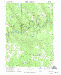 1967 Cooksburg1971 Print · USGSThe Clarion River winds through the heart of the Pennsylvania woods during the late sixties, marking the borders of three counties. Local historians can trace old community sites like Hottelville and Kahletown, or find family landmarks such as Troutman Cem and Shawkey Hill.5 unique versions available
 - 1967 Map of Marienville West, 1971 Print
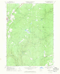
 1967 Marienville West1971 Print · USGSForest and Clarion counties in the late sixties reveal a landscape defined by state forests and the energy industry. Genealogists and historians can trace the Baltimore and Ohio line to remote stops like Vowinckel, find the Muzette Lookout Tower, or locate country churches like Greenwood Ch.3 unique versions available
 - 1967 Map of Sigel, 1971 Print
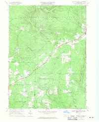
 1967 Sigel1971 Print · USGSJefferson and Forest counties meet along the Clarion River in the late sixties, where timber and energy production shaped the landscape. Genealogists can locate family landmarks like Mt Tabor Cem, the Edeburn Ch, and the remote Heitiff Pumping Station.5 unique versions available
 - 1967 Map of Marienville East, 1971 Print
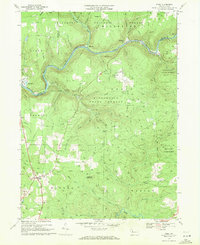
 1967 Marienville East1971 Print · USGSForest County in the late sixties reveals a landscape shaped by both the timber industry and the energy sector. Genealogists and researchers can trace the roads around McCrays, Lamonaville, and the North Forest Cem or locate the Baltimore and Ohio rail line.3 unique versions available
End of results
Showing maps 1-4 of 4
Top cities near Barnett Township
- Clarion historical maps
- Brookville historical maps
- Limestone Township historical maps
- Warsaw Township historical maps
- Strattanville historical maps
- Corsica historical maps
See more
Top neighborhoods of Barnett Township
Frequently asked questions
- What are the different types of historical maps available for Barnett Township?
- What is the oldest map of Barnett Township?
- Where can I purchase historical maps of Barnett Township for my home or office?
- Where can I download high-res historical maps of Barnett Township?
- Are there historical topographic maps available for Barnett Township?
- Is there historical aerial imagery available for Barnett Township?
- Where are historical maps of Barnett Township sourced from?