1990s Maps of Indiana County, Pennsylvania
Explore 4 historic maps of Indiana County from the 1990s. These maps offer a rare glimpse into what life looked like during the 1990s — showing old roads, neighborhoods, homes, and landmarks that have changed or disappeared over time.
Whether you're researching your family's past, planning a metal detecting trip, or studying how Indiana County's landscape evolved across the 1990s, these high-resolution maps are a powerful tool for exploring the history of this region.
- Focus on a specific era: All maps on this page are from the 1990s, giving you a focused view of this time period.
- See what’s changed: Compare century-old streets, trails, and buildings to today's modern landscape using overlays and satellite layers.
- Research with precision: Use these maps for genealogy, historical research, land use analysis, or educational projects.
- View, download, or print: Maps are fully viewable online in high resolution, and can be downloaded or printed for your own records.
Start exploring Indiana County's history through authentic maps from the 1990s. This is your window into the past.
Indiana County, PA maps
(4)- 1998 Map of Vintondale, 1999 Print
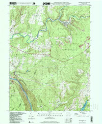 1998 Vintondale1999 Print · USGSIn the late nineties, the area around Vintondale and Wehrum remains defined by its deep mining heritage and the winding Blacklick Creek. Genealogists and historians can locate family landmarks like Memorial Ch and Delano Sch, or trace the old CONRAIL line and the Gallitzin Trail.
 - 1998 Map of Avonmore, 1999 Print
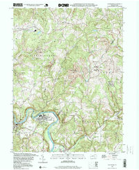 1998 Avonmore1999 Print · USGSThe loop of the Kiskiminetas River defines this landscape in the late nineties, where coal-rich townships meet the river's bend. Genealogists and historians can trace the foundations of local life through the Spring Church, West View Cem, and the Elders Ridge Joint High Sch.
 - 1998 Map of Brush Valley, 1999 Print
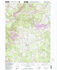 1998 Brush Valley1999 Print · USGSIndiana County in the late nineties showcases a landscape of major reservoirs and rural hamlets. Researchers can trace family history through numerous burial sites like Harmony Cem or explore the industrial footprint of Strip Mines near Brush Valley.
 - 1998 Map of Rachelwood, 2000 Print
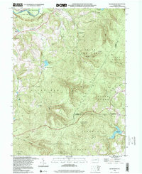 1998 Rachelwood2000 Print · USGSThe Westmoreland and Cambria county line area in the late nineties showcases a landscape of protected highlands and mountain reservoirs. Researchers can trace historic industrial sites like Baldwin Furnace and community anchors such as Legat Cem and Rachelwood.
End of results
Showing maps 1-4 of 4
Top cities of Indiana County
- Indiana historical maps
- Blairsville historical maps
- Rayne Township historical maps
- Brush Valley Township historical maps
- Homer City historical maps
- Clymer historical maps
See more
Frequently asked questions
- What are the different types of historical maps available for Indiana County?
- What is the oldest map of Indiana County?
- Where can I purchase historical maps of Indiana County for my home or office?
- Where can I download high-res historical maps of Indiana County?
- Are there historical topographic maps available for Indiana County?
- Is there historical aerial imagery available for Indiana County?
- Where are historical maps of Indiana County sourced from?