1960s Maps of Pine Township, Pennsylvania
Explore 5 historic maps of Pine Township from the 1960s. These maps offer a rare glimpse into what life looked like during the 1960s — showing old roads, neighborhoods, homes, and landmarks that have changed or disappeared over time.
Whether you're researching your family's past, planning a metal detecting trip, or studying how Pine Township's landscape evolved across the 1960s, these high-resolution maps are a powerful tool for exploring the history of this region.
- Focus on a specific era: All maps on this page are from the 1960s, giving you a focused view of this time period.
- See what’s changed: Compare century-old streets, trails, and buildings to today's modern landscape using overlays and satellite layers.
- Research with precision: Use these maps for genealogy, historical research, land use analysis, or educational projects.
- View, download, or print: Maps are fully viewable online in high resolution, and can be downloaded or printed for your own records.
Start exploring Pine Township's history through authentic maps from the 1960s. This is your window into the past.
Pine Township, PA maps
(5)- 1961 Map of Commodore, 1963 Print
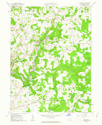 1961 Commodore1963 Print · USGSIndiana County's mining and rail landscape is captured here in the early sixties, showing the active extraction economy around Commodore and Starford. Genealogists and historians can trace family locations near Learn Settlement, Wandin Junction, or rural landmarks like Laurel Swamp Union Ch.5 unique versions available
 - 1961 Map of Barnesboro, 1963 Print
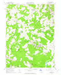
 1961 Barnesboro1963 Print · USGSIn the early 1960s, the mining communities of Cambria and Indiana counties were at their peak along the West Branch Susquehanna River. Genealogists can trace family roots through numerous sites like St Marys Cem, McDowell Cem, and the small settlement of Moss Creek.6 unique versions available
 - 1961 Map of Colver, 1963 Print
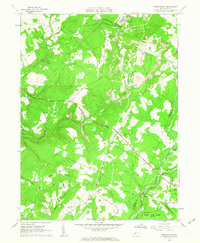
 1961 Colver1963 Print · USGSCambria County coal country is captured here during the early sixties, centered on the company-built hub of Colver. Genealogists and local historians can trace family locations near Nine Row, find rural landmarks like St Nicholas Sch, or locate burials at Colver Cem.4 unique versions available
 - 1961 Map of Strongstown, 1963 Print
 1961 Strongstown1963 Print · USGSIndiana County and the Cambria County border appear here during the early sixties, a landscape where coal mining and timbering met traditional farming. Researchers can trace the Cherry Tree and Dixonville Railroad or locate local landmarks like Ewings Mill and Barkley Ch.4 unique versions available
 - 1964 Map of Pittsburgh
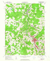
 1964 Pittsburgh1964 Print · USGSWestern Pennsylvania in the late fifties and early sixties shows a landscape of powerful river industries and expanding highways. Genealogists and historians can trace the rail corridors of the Pennsylvania RR through industrial hubs like Johnstown, Altoona, and Nanty Glo.
End of results
Showing maps 1-5 of 5
Top cities near Pine Township
- Indiana historical maps
- Northern Cambria historical maps
- Rayne Township historical maps
- Ebensburg historical maps
- Nanty Glo historical maps
- Brush Valley Township historical maps
See more
Top neighborhoods of Pine Township
- Strongstown historical maps
- Jewtown historical maps
- Stiles Crossing historical maps
- Nolo historical maps
- Pineton historical maps
- Alverda historical maps
See more
Frequently asked questions
- What are the different types of historical maps available for Pine Township?
- What is the oldest map of Pine Township?
- Where can I purchase historical maps of Pine Township for my home or office?
- Where can I download high-res historical maps of Pine Township?
- Are there historical topographic maps available for Pine Township?
- Is there historical aerial imagery available for Pine Township?
- Where are historical maps of Pine Township sourced from?