1900s (20th Century) Maps of White Township, Pennsylvania
Explore 12 historic maps of White Township from the 1900s (20th Century). These maps offer a rare glimpse into what life looked like during the 1900s — showing old roads, neighborhoods, homes, and landmarks that have changed or disappeared over time.
Whether you're researching your family's past, planning a metal detecting trip, or studying how White Township's landscape evolved across the 1900s, these high-resolution maps are a powerful tool for exploring the history of this region.
- Focus on a specific era: All maps on this page are from the 1900s, giving you a focused view of this time period.
- See what’s changed: Compare century-old streets, trails, and buildings to today's modern landscape using overlays and satellite layers.
- Research with precision: Use these maps for genealogy, historical research, land use analysis, or educational projects.
- View, download, or print: Maps are fully viewable online in high resolution, and can be downloaded or printed for your own records.
Start exploring White Township's history through authentic maps from the 1900s. This is your window into the past.
White Township, PA maps
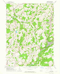
(12)- 1902 Map of Indiana
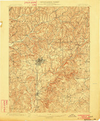 1902 Indiana1902 Print · USGSIndiana County at the turn of the century shows a landscape of growing rail towns and rural farmsteads connected by the Pennsylvania Railroad. Researchers can trace ancestral roots through vanished crossroads and early industrial sites like Homer, Mechanicsburg, and Graceton.8 unique versions available
 - 1953 Map of Pittsburgh
 1953 Pittsburgh1953 Print · USGSWestern Pennsylvania's industrial landscape at the start of the fifties shows the steel and rail corridors between Pittsburgh and Altoona. Trace family roots in river towns like Tarentum or follow the Pennsylvania Turnpike across Laurel Hill.
 - 1954 Map of Pittsburgh
 1954 Pittsburgh1954 Print · USGSWestern Pennsylvania in the early fifties remains a powerhouse of heavy industry and vital transit corridors. Genealogists and historians can trace the rail-and-river network connecting Pittsburgh, Johnstown, and Altoona via the Pennsylvania RR and the Lincoln Highway.2 unique versions available
 - 1958 Map of Pittsburgh
 1958 Pittsburgh1958 Print · USGSWestern Pennsylvania in the late fifties shows an industrial heartland defined by the confluence of the Allegheny River and Monongahela River. Researchers can trace the sprawling rail networks of the Pennsylvania RR and find established towns like Butler, Latrobe, and Windber.5 unique versions available
 - 1959 Map of Pittsburgh
 1959 Pittsburgh1959 Print · USGSWestern Pennsylvania in the late fifties is captured here at the height of its industrial era. Genealogists and historians can trace the riverfront growth of Pittsburgh, the rail works at Altoona, and the mountain gaps of Laurel Hill.
 - 1963 Map of Brush Valley, 1965 Print
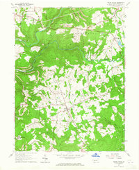 1963 Brush Valley1965 Print · USGSIndiana County's coal country and rural hamlets are mapped here during the early sixties, showing the region's transition from agricultural roots to industrial extraction. Researchers can locate numerous family cemeteries like Evans Cem and Frye Cem, or trace the extent of Strip Mines near Waterman and Luciusboro.4 unique versions available
 - 1963 Map of Indiana, 1965 Print
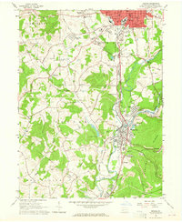 1963 Indiana1965 Print · USGSIndiana County in the early sixties is a landscape shaped by coal mining and a complex rail network. Genealogists and local historians can trace the foundations of Homer City and Lucerne Mines, or locate the Willard Orphanage County Home.4 unique versions available
 - 1963 Map of Ernest, 1965 Print
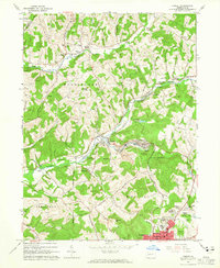 1963 Ernest1965 Print · USGSIndiana County was a hub of coal and rail activity in the 1960s, centered on the growing northern suburbs of Indiana. Researchers can trace historic industrial sites like the Mina Dump or locate ancestral sites such as Old Washington Cem and Harmony Grove Ch.4 unique versions available
 - 1963 Map of Clymer, 1965 Print
 1963 Clymer1965 Print · USGSIndiana County's coal-and-rail landscape is captured here in the early sixties, showing the industrial heart of Clymer and its neighboring townships. Trace the footprint of local industry and community through numerous strip mines, the Wesleyan Sch, and the Kintersburg Bridge.4 unique versions available
 - 1964 Map of Pittsburgh
 1964 Pittsburgh1964 Print · USGSWestern Pennsylvania in the late fifties and early sixties shows a landscape of powerful river industries and expanding highways. Genealogists and historians can trace the rail corridors of the Pennsylvania RR through industrial hubs like Johnstown, Altoona, and Nanty Glo.
 - 1983 Map of Indiana
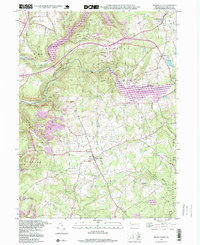
 1983 Indiana1983 Print · USGSWestern Pennsylvania in the early eighties shows a landscape of industrial river towns and expanding university campuses. Genealogists can trace family roots through Lucernemines and Spring Church, or locate ancestors in Oakland Cemetery.
 - 1998 Map of Brush Valley, 1999 Print
 1998 Brush Valley1999 Print · USGSIndiana County in the late nineties showcases a landscape of major reservoirs and rural hamlets. Researchers can trace family history through numerous burial sites like Harmony Cem or explore the industrial footprint of Strip Mines near Brush Valley.
End of results
Showing maps 1-12 of 12
Top cities near White Township
- Indiana historical maps
- Blairsville historical maps
- Rayne Township historical maps
- Brush Valley Township historical maps
- Homer City historical maps
- Clymer historical maps
See more
Top neighborhoods of White Township
- Ben Avon historical maps
- Getty Heights historical maps
- Grandview historical maps
- Indian Springs Estates historical maps
- Pleasant Hill historical maps
- Bryan Hill Manor historical maps
See more
Frequently asked questions
- What are the different types of historical maps available for White Township?
- What is the oldest map of White Township?
- Where can I purchase historical maps of White Township for my home or office?
- Where can I download high-res historical maps of White Township?
- Are there historical topographic maps available for White Township?
- Is there historical aerial imagery available for White Township?
- Where are historical maps of White Township sourced from?