1940s Maps of Jefferson County, Pennsylvania
Explore 10 historic maps of Jefferson County from the 1940s. These maps offer a rare glimpse into what life looked like during the 1940s — showing old roads, neighborhoods, homes, and landmarks that have changed or disappeared over time.
Whether you're researching your family's past, planning a metal detecting trip, or studying how Jefferson County's landscape evolved across the 1940s, these high-resolution maps are a powerful tool for exploring the history of this region.
- Focus on a specific era: All maps on this page are from the 1940s, giving you a focused view of this time period.
- See what’s changed: Compare century-old streets, trails, and buildings to today's modern landscape using overlays and satellite layers.
- Research with precision: Use these maps for genealogy, historical research, land use analysis, or educational projects.
- View, download, or print: Maps are fully viewable online in high resolution, and can be downloaded or printed for your own records.
Start exploring Jefferson County's history through authentic maps from the 1940s. This is your window into the past.
Jefferson County, PA maps
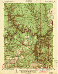
(10)- 1940 Map of Hallton
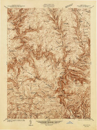 1940 Hallton1940 Print · USGSElk and Jefferson Counties appear here in the early 1940s, showing a landscape defined by the Clarion River valley and the growth of the Allegheny National Forest. Researchers can find old industrial sites and rural landmarks like the Empire Tunnel, St Tobias Cem, and the CCC Camp.3 unique versions available
 - 1941 Map of Marienville
 1941 Marienville1941 Print · USGSForest, Clarion, and Jefferson counties meet along the winding Clarion River in this pre-war survey of northern Pennsylvania's timberlands. Genealogists can locate numerous rural schoolhouses and social landmarks like Kahletown Hall, Greenwood Ch, and the Downey Cem.3 unique versions available
 - 1941 Map of Ridgway, 1956 Print
 1941 Ridgway1956 Print · USGSElk County at the start of the 1940s reveals a landscape shaped by coal mining and heavy rail industry. Genealogists can locate family homes near Dagus Mines or trace the early foundations of Ridgway and St. Marys.2 unique versions available
 - 1942 Map of Punxsutawney
 1942 Punxsutawney1942 Print · USGSWest-central Pennsylvania during the early war years reveals a landscape shaped by rail transport and deep-rooted rural communities. Researchers can trace the legacy of local education and industry through dozens of named sites like Harmony Thomas School, McGees Mills, and Bells Mills.2 unique versions available
 - 1943 Map of Punxsutawney
 1943 Punxsutawney1943 Print · USGSThe Pennsylvania coal country around the turn of the century and through the war years is captured in this detailed survey of Jefferson, Indiana, and Clearfield counties. Researchers can trace the rail-reliant economy through Findley Mills, Rossiter Junction, and landmarks like the St Lawrence Fire Tower.
 - 1943 Map of Hallton
 1943 Hallton1943 Print · USGSThe Clarion River valley and surrounding plateau are captured here just before the mid-century, revealing a network of isolated settlements and forest industry. Researchers can find old sites like the CCC Camp near Croyland, the Empire Tunnel, and small rural schools including Lake City Sch.3 unique versions available
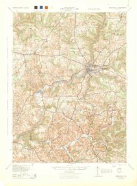
 - 1944 Map of Du Bois
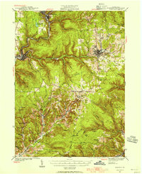
 1944 Du Bois1944 Print · USGSJefferson and Clearfield counties are shown during the height of their industrial era in the 1940s. Genealogists can locate family-named landmarks like Groves Sch or McAninch Sch and trace the operations at Eleanora Mines.
 - 1944 Map of Brookville
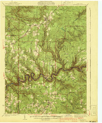
 1944 Brookville1944 Print · USGSThe Jefferson and Clarion County borderlands come alive in the 1940s, showing a landscape defined by river-valley railroads and rural school districts. Researchers can trace the lineage of local communities through landmarks like Mead Chapel, the mining works at Conifer, and old post offices in Worthville or Markton.
 - 1944 Map of Ridgway
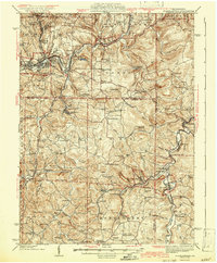
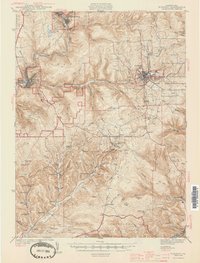 1944 Ridgway1944 Print · USGSElk County at the height of its industrial rail era reveals a landscape of coal mines and mountain settlements. Trace the operations of the Toby Mine and Kyler Mine or find family roots at Decker Chapel and Gardner Hill Sch.3 unique versions available
 - 1949 Map of Brookville
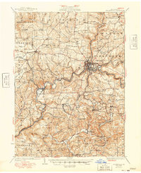 1949 Brookville1949 Print · USGSJefferson County settlement at the end of the 1940s centers on the river junctions and rail lines near Brookville. Genealogists can trace family footprints across dozens of country schoolhouses like Oaks School and villages like Summerville or Knoxdale.
End of results
Showing maps 1-10 of 10
Top cities of Jefferson County
- Punxsutawney historical maps
- Brookville historical maps
- Reynoldsville historical maps
- Brockway historical maps
- Warsaw Township historical maps
- Sykesville historical maps
See more
Frequently asked questions
- What are the different types of historical maps available for Jefferson County?
- What is the oldest map of Jefferson County?
- Where can I purchase historical maps of Jefferson County for my home or office?
- Where can I download high-res historical maps of Jefferson County?
- Are there historical topographic maps available for Jefferson County?
- Is there historical aerial imagery available for Jefferson County?
- Where are historical maps of Jefferson County sourced from?