1900-1909 Maps of Young Township, Pennsylvania
Explore 2 historic maps of Young Township from 1900-1909. These maps offer a rare glimpse into what life looked like during the 1900s — showing old roads, neighborhoods, homes, and landmarks that have changed or disappeared over time.
Whether you're researching your family's past, planning a metal detecting trip, or studying how Young Township's landscape evolved across the 1900s, these high-resolution maps are a powerful tool for exploring the history of this region.
- Focus on a specific era: All maps on this page are from the 1900s, giving you a focused view of this time period.
- See what’s changed: Compare century-old streets, trails, and buildings to today's modern landscape using overlays and satellite layers.
- Research with precision: Use these maps for genealogy, historical research, land use analysis, or educational projects.
- View, download, or print: Maps are fully viewable online in high resolution, and can be downloaded or printed for your own records.
Start exploring Young Township's history through authentic maps from the 1900s. This is your window into the past.
Young Township, PA maps
(2)- 1906 Map of Punxsutawney
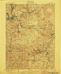 1906 Punxsutawney1906 Print · USGSPunxsutawney and the surrounding coal townships of the early 1900s are captured here at the height of the region's industrial growth. Genealogists and historians can trace the specific locations of historic post offices like Adrian and Gettysburg alongside family-named sites such as Bella Mills.4 unique versions available
 - 1909 Map of Smicksburg
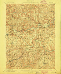 1909 Smicksburg1909 Print · USGSIndiana and Jefferson Counties are seen here in the early twentieth century as a complex network of small hamlets and emerging rail lines. Genealogists can trace family roots through specific landmarks like Motterns Mill, Mt Zion Church, and the dual-named New Salem Pierce PO.2 unique versions available
End of results
Showing maps 1-2 of 2
Top cities near Young Township
- Sandy Township historical maps
- DuBois historical maps
- Punxsutawney historical maps
- Brookville historical maps
- Rayne Township historical maps
- Winslow historical maps
See more
Top neighborhoods of Young Township
- Walston historical maps
- Harmony historical maps
- Crawfordtown historical maps
- Horatio historical maps
- Sportsburg historical maps
- Adrian Mines historical maps
Frequently asked questions
- What are the different types of historical maps available for Young Township?
- What is the oldest map of Young Township?
- Where can I purchase historical maps of Young Township for my home or office?
- Where can I download high-res historical maps of Young Township?
- Are there historical topographic maps available for Young Township?
- Is there historical aerial imagery available for Young Township?
- Where are historical maps of Young Township sourced from?