1940s Maps of Juniata County, Pennsylvania
Explore 7 historic maps of Juniata County from the 1940s. These maps offer a rare glimpse into what life looked like during the 1940s — showing old roads, neighborhoods, homes, and landmarks that have changed or disappeared over time.
Whether you're researching your family's past, planning a metal detecting trip, or studying how Juniata County's landscape evolved across the 1940s, these high-resolution maps are a powerful tool for exploring the history of this region.
- Focus on a specific era: All maps on this page are from the 1940s, giving you a focused view of this time period.
- See what’s changed: Compare century-old streets, trails, and buildings to today's modern landscape using overlays and satellite layers.
- Research with precision: Use these maps for genealogy, historical research, land use analysis, or educational projects.
- View, download, or print: Maps are fully viewable online in high resolution, and can be downloaded or printed for your own records.
Start exploring Juniata County's history through authentic maps from the 1940s. This is your window into the past.
Juniata County, PA maps
(7)- 1941 Map of East Waterford
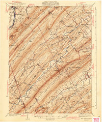 1941 East Waterford1941 Print · USGSThe Ridge-and-Valley province of Central Pennsylvania appears here in the years before the war, dominated by the great parallel spans of Tuscarora Mountain. Genealogists can locate family sites among numerous rural institutions like Pine Glen Ch, McCullochs Mills, and the CCC Camp at East Waterford.3 unique versions available
 - 1943 Map of Millerstown
 1943 Millerstown1943 Print · USGSMid-Pennsylvania ridge-and-valley life is captured here during the 1940s as the Juniata River corridor serves the Pennsylvania Railroad. Genealogists and historians can locate numerous rural landmarks like Beers Foundry, Arbogast Church, and the Hiester Valley School.
 - 1943 Map of Millersburg
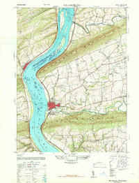
 1943 Millersburg1943 Print · USGSDauphin and Northumberland counties appear here during the mid-1940s, defined by the river-and-rail economy along the Susquehanna River. Researchers can trace the heritage of small valley towns through landmarks like St Johns Church, Morning Glory School, and the Limestone Quarries.
 - 1943 Map of Lewistown
 1943 Lewistown1943 Print · USGSCentral Pennsylvania's rugged ridge-and-valley landscape is documented here during the mid-forties, showing the deep integration of rail lines and mountain gaps. Genealogists can trace family footprints through numerous rural landmarks like Emma Chapel, Mattern Junction, and the McNitt School.
 - 1944 Map of Mt. Union
 1944 Mt. Union1944 Print · USGSThe Juniata River valley and the ridges of Huntingdon and Mifflin counties are shown here at the peak of the rail era. Genealogists and historians can trace the locations of dozens of vanished schoolhouses like Lucy Furnace Sch and rural outposts like Atkinson Mills or Mapleton Depot.
 - 1947 Map of Millersburg
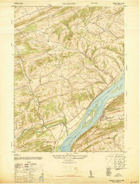
 1947 Millersburg1947 Print · USGSThe Susquehanna River valley and the ridges of Central Pennsylvania are captured here just after the war. Local historians can trace family sites like Killinger School, navigate the Millersburg Ferry, and locate old river crossings such as Montgomery Ferry.2 unique versions available
 - 1947 Map of Dalmatia
 1947 Dalmatia1947 Print · USGSThe Susquehanna River corridor in the late 1940s serves as a vital artery for the Pennsylvania Railroad and the historic Susquehanna Trail. Genealogists and local historians can trace family roots through numerous rural landmarks like Aline School, Bot Schafts Church, and the riverfront village of Dalmatia.2 unique versions available
End of results
Showing maps 1-7 of 7
Top cities of Juniata County
- Port Royal historical maps
- Mifflintown historical maps
- Spruce Hill Township historical maps
- Thompsontown historical maps
- Mifflin historical maps
Frequently asked questions
- What are the different types of historical maps available for Juniata County?
- What is the oldest map of Juniata County?
- Where can I purchase historical maps of Juniata County for my home or office?
- Where can I download high-res historical maps of Juniata County?
- Are there historical topographic maps available for Juniata County?
- Is there historical aerial imagery available for Juniata County?
- Where are historical maps of Juniata County sourced from?