Old Maps of Juniata County, Pennsylvania for Hiking & Exploration
Hike through history with 79 historic maps of Juniata County. Explore old trails, ghost towns, and forgotten backroads — perfect for outdoor adventurers and local explorers.
- Rediscover forgotten places: Map out old mining camps, roads, and footpaths that no longer exist on modern maps.
- Layer with modern tools: Combine with LiDAR or satellite views to plan hikes through historical terrain.
- Made for exploration: Popular among hikers, overlanders, and local history lovers.
Use these maps to find adventure and explore the hidden past of Juniata County.
Juniata County, PA maps
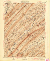
(79)- 1893 Map of Millersburg
 1893 Millersburg1893 Print · USGSThe Susquehanna River valley in the 1890s shows a landscape shaped by competing transport systems and mountain ridges. Trace the path of the Pennsylvania Canal through Liverpool or locate family roots in Millersburg and Elizabethville.7 unique versions available
 - 1907 Map of Millerstown
 1907 Millerstown1907 Print · USGSThe Juniata River and Pennsylvania RR dominate this early twentieth-century survey of the central Pennsylvania ridge-and-valley country. Genealogists can trace family roots through numerous specific landmarks like Browns Mill Cocolamus PO, Gimbelings Mill, and St Peters Church.4 unique versions available
 - 1919 Map of Mattawana
 1919 Mattawana1919 Print · USGSCentral Pennsylvania's ridge-and-valley network is captured here at the end of the Great War, showing a landscape defined by small mill towns and diverging rail lines. Genealogists can trace family names and ancestral homes in McCulloch Mills, E. Waterford, and Blairs Mills.
 - 1922 Map of Mt Union
 1922 Mt Union1922 Print · USGSThe Juniata River valley in the early 1920s reveals a landscape shaped by the Pennsylvania RR and early motor routes like the Lincoln Highway. Genealogists can trace dozens of rural schoolhouses and vanished post offices, including Red Fork PO, Shirleysburg, and Lucy Furnace School.2 unique versions available
 - 1924 Map of Mt. Union
 1924 Mt. Union1924 Print · USGSMount Union and the central Juniata River valley are shown here in the mid-twenties as the rail-and-river economy flourished. Genealogists can locate dozens of named rural schools like Smoke School and old post offices such as Shade Valley P.O.4 unique versions available
 - 1924 Map of Lewistown, 1958 Print
 1924 Lewistown1958 Print · USGSMifflin County settlements line the river and valley floor during the mid-1920s, showing the region's transition from agrarian mills to industrial rail hubs. Researchers can locate vanished rural landmarks such as Union Mills, Emma Chapel, and numerous family-named sites like Strodes Mills.2 unique versions available
 - 1925 Map of Mifflintown
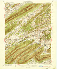
 1925 Mifflintown1925 Print · USGSJuniata County in the mid-1920s is a landscape of river-oriented towns and remote mountain gaps. Genealogists and historians can trace family roots through numerous local landmarks like Peach Blossom School, Jericho Mills, and the village of Mifflintown.
 - 1927 Map of Lewisburg
 1927 Lewisburg1927 Print · USGSThe central Pennsylvania landscape in the 1920s is defined here by the winding Juniata River and the industrial hubs of Lewistown and Burnham. Local historians can trace old river crossings like Lafolds Ford or the many rural schoolhouses like Yoder School and Brice School.5 unique versions available
 - 1930 Map of Loysville, 1953 Print
 1930 Loysville1953 Print · USGSPerry County's rural heartland is meticulously detailed in the 1930s, showing a landscape of ridge-and-valley farms and forest camps. Genealogists can trace family roots through numerous local landmarks like St Paul Ch, Academia Sch, and Loysville.
 - 1933 Map of Loysville
 1933 Loysville1933 Print · USGSPerry County's rural heartland is shown in detail during the early 1930s, when isolated valleys were still dotted with one-room schoolhouses and family farms. Genealogists can trace family footprints through sites like Fort Robinson, Cisna Run, and the numerous local schools like Oak Grove Sch.3 unique versions available
 - 1934 Map of Mifflintown, 1962 Print
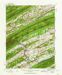 1934 Mifflintown1962 Print · USGSThe Juniata River valley and the ridges of the Pennsylvania heartland appear here in the mid-1930s. Researchers can trace the path of the Pennsylvania RR through Mifflintown or locate family landmarks like Raubs Mills, Seawra Cave, and Church Hill Sch.
 - 1936 Map of East Waterford
 1936 East Waterford1936 Print · USGSThe ridge-and-valley corridor of Juniata and Perry Counties is captured here in the mid-1930s, showing a landscape defined by narrow mountain gaps and small milling hubs. Researchers can trace ancestral roots through dozens of rural schools and churches, including McCulloughs Mills, Honey Grove, and Fairview Ch and Sch.2 unique versions available
 - 1937 Map of Mifflintown
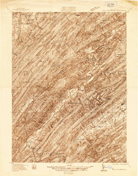
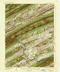 1937 Mifflintown1937 Print · USGSJuniata County in the mid-1930s shows a landscape of tight-knit valley communities and mountain gaps along the Juniata River. Genealogists and historians can trace family locations near dozens of rural landmarks, including Oakland Mills, Port Royal, and the Old Port Sch.3 unique versions available
 - 1941 Map of East Waterford
 1941 East Waterford1941 Print · USGSThe Ridge-and-Valley province of Central Pennsylvania appears here in the years before the war, dominated by the great parallel spans of Tuscarora Mountain. Genealogists can locate family sites among numerous rural institutions like Pine Glen Ch, McCullochs Mills, and the CCC Camp at East Waterford.3 unique versions available
 - 1943 Map of Millerstown
 1943 Millerstown1943 Print · USGSMid-Pennsylvania ridge-and-valley life is captured here during the 1940s as the Juniata River corridor serves the Pennsylvania Railroad. Genealogists and historians can locate numerous rural landmarks like Beers Foundry, Arbogast Church, and the Hiester Valley School.
 - 1943 Map of Millersburg
 1943 Millersburg1943 Print · USGSDauphin and Northumberland counties appear here during the mid-1940s, defined by the river-and-rail economy along the Susquehanna River. Researchers can trace the heritage of small valley towns through landmarks like St Johns Church, Morning Glory School, and the Limestone Quarries.
 - 1943 Map of Lewistown
 1943 Lewistown1943 Print · USGSCentral Pennsylvania's rugged ridge-and-valley landscape is documented here during the mid-forties, showing the deep integration of rail lines and mountain gaps. Genealogists can trace family footprints through numerous rural landmarks like Emma Chapel, Mattern Junction, and the McNitt School.
 - 1944 Map of Mt. Union
 1944 Mt. Union1944 Print · USGSThe Juniata River valley and the ridges of Huntingdon and Mifflin counties are shown here at the peak of the rail era. Genealogists and historians can trace the locations of dozens of vanished schoolhouses like Lucy Furnace Sch and rural outposts like Atkinson Mills or Mapleton Depot.
 - 1947 Map of Millersburg
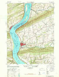 1947 Millersburg1947 Print · USGSThe Susquehanna River valley and the ridges of Central Pennsylvania are captured here just after the war. Local historians can trace family sites like Killinger School, navigate the Millersburg Ferry, and locate old river crossings such as Montgomery Ferry.2 unique versions available
 - 1947 Map of Dalmatia
 1947 Dalmatia1947 Print · USGSThe Susquehanna River corridor in the late 1940s serves as a vital artery for the Pennsylvania Railroad and the historic Susquehanna Trail. Genealogists and local historians can trace family roots through numerous rural landmarks like Aline School, Bot Schafts Church, and the riverfront village of Dalmatia.2 unique versions available
 - 1950 Map of Harrisburg, 1952 Print
 1950 Harrisburg1952 Print · USGSMid-century Central Pennsylvania comes alive through its dense rail networks and river valley settlements during the post-war industrial era. Genealogists and historians can trace family roots through hubs like Harrisburg, locate Carlisle Barracks, or follow the Pennsylvania RR through the Lebanon Valley.
 - 1952 Map of Spruce Hill, 1958 Print
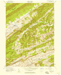
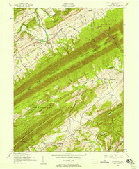 1952 Spruce Hill1958 Print · USGSJuniata and Perry counties are shown here in the early fifties, split by the prominent ridgelines of the Appalachian Mountains. Genealogists and local historians can trace family locations near Academia, Matamoras School and Church, and the Lower Tuscarora Church and Cemetery.4 unique versions available
 - 1952 Map of Ickesburg, 1958 Print
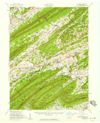
 1952 Ickesburg1958 Print · USGSCentral Pennsylvania's ridge-and-valley landscape is captured here in the early 1950s, showing a network of rural townships and mountain gaps. Genealogists can locate family landmarks like Eshcol Memorial Cemetery, Ickesburg High School, and the dismantled railroad through Greenpark.4 unique versions available
 - 1952 Map of Loysville, 1959 Print
 1952 Loysville1959 Print · USGSPerry County and the Juniata border at mid-century are defined by the ridgelines of the Appalachians and the legacy of the timber and rail era. Genealogists can trace family roots at Eshcol Cem or Emory Chapel Cem and locate schools like Manassa Sch.2 unique versions available
 - 1953 Map of Millersburg, 1956 Print
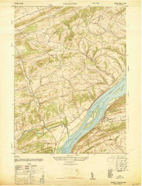
 1953 Millersburg1956 Print · USGSCentral Pennsylvania's river valleys and mountain ridges are captured here during the early fifties, showing a landscape defined by the Susquehanna River. Researchers can locate vanished landmarks like the Abandoned Canal, the Oakdale Sta, and numerous country schools including Keiters Sch.3 unique versions available
Showing maps 1-25 of 79
Top cities of Juniata County
- Port Royal historical maps
- Mifflintown historical maps
- Spruce Hill Township historical maps
- Mifflin historical maps
- Thompsontown historical maps
Frequently asked questions
- What are the different types of historical maps available for Juniata County?
- What is the oldest map of Juniata County?
- Where can I purchase historical maps of Juniata County for my home or office?
- Where can I download high-res historical maps of Juniata County?
- Are there historical topographic maps available for Juniata County?
- Is there historical aerial imagery available for Juniata County?
- Where are historical maps of Juniata County sourced from?