1900s (20th Century) Maps of Fayette Township, Pennsylvania
Explore 18 historic maps of Fayette Township from the 1900s (20th Century). These maps offer a rare glimpse into what life looked like during the 1900s — showing old roads, neighborhoods, homes, and landmarks that have changed or disappeared over time.
Whether you're researching your family's past, planning a metal detecting trip, or studying how Fayette Township's landscape evolved across the 1900s, these high-resolution maps are a powerful tool for exploring the history of this region.
- Focus on a specific era: All maps on this page are from the 1900s, giving you a focused view of this time period.
- See what’s changed: Compare century-old streets, trails, and buildings to today's modern landscape using overlays and satellite layers.
- Research with precision: Use these maps for genealogy, historical research, land use analysis, or educational projects.
- View, download, or print: Maps are fully viewable online in high resolution, and can be downloaded or printed for your own records.
Start exploring Fayette Township's history through authentic maps from the 1900s. This is your window into the past.
Fayette Township, PA maps
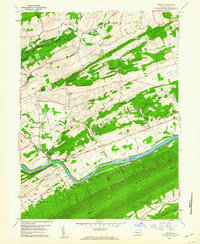
(18)- 1907 Map of Millerstown
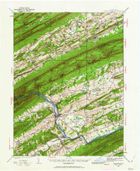
 1907 Millerstown1907 Print · USGSThe Juniata River and Pennsylvania RR dominate this early twentieth-century survey of the central Pennsylvania ridge-and-valley country. Genealogists can trace family roots through numerous specific landmarks like Browns Mill Cocolamus PO, Gimbelings Mill, and St Peters Church.4 unique versions available
 - 1925 Map of Mifflintown
 1925 Mifflintown1925 Print · USGSJuniata County in the mid-1920s is a landscape of river-oriented towns and remote mountain gaps. Genealogists and historians can trace family roots through numerous local landmarks like Peach Blossom School, Jericho Mills, and the village of Mifflintown.
 - 1934 Map of Mifflintown, 1962 Print
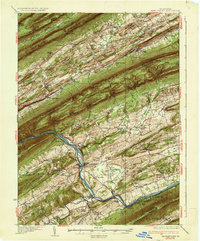
 1934 Mifflintown1962 Print · USGSThe Juniata River valley and the ridges of the Pennsylvania heartland appear here in the mid-1930s. Researchers can trace the path of the Pennsylvania RR through Mifflintown or locate family landmarks like Raubs Mills, Seawra Cave, and Church Hill Sch.
 - 1937 Map of Mifflintown
 1937 Mifflintown1937 Print · USGSJuniata County in the mid-1930s shows a landscape of tight-knit valley communities and mountain gaps along the Juniata River. Genealogists and historians can trace family locations near dozens of rural landmarks, including Oakland Mills, Port Royal, and the Old Port Sch.3 unique versions available
 - 1943 Map of Millerstown
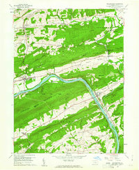
 1943 Millerstown1943 Print · USGSMid-Pennsylvania ridge-and-valley life is captured here during the 1940s as the Juniata River corridor serves the Pennsylvania Railroad. Genealogists and historians can locate numerous rural landmarks like Beers Foundry, Arbogast Church, and the Hiester Valley School.
 - 1950 Map of Harrisburg, 1952 Print
 1950 Harrisburg1952 Print · USGSMid-century Central Pennsylvania comes alive through its dense rail networks and river valley settlements during the post-war industrial era. Genealogists and historians can trace family roots through hubs like Harrisburg, locate Carlisle Barracks, or follow the Pennsylvania RR through the Lebanon Valley.
 - 1955 Map of Millerstown, 1957 Print
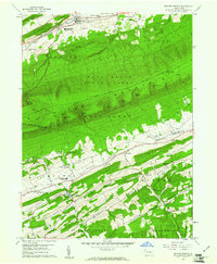
 1955 Millerstown1957 Print · USGSThe Juniata River valley and the ridges of Perry, Juniata, and Snyder Counties are captured here during the mid-fifties. Researchers can trace family roots through numerous country landmarks including Lauvers Ch, Koons Cem, and the old rail siding at Millerstown Sta.3 unique versions available
 - 1957 Map of Harrisburg
 1957 Harrisburg1957 Print · USGSMid-century Central Pennsylvania comes into focus as a bustling network of rail, river, and mountain ridges. Genealogists and historians can trace the development of the State Capitol and surrounding hubs like Middletown, Columbia, and Pottsville.7 unique versions available
 - 1959 Map of Mc Clure, 1960 Print
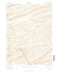
 1959 Mc Clure1960 Print · USGSJuniata and Snyder counties are captured here in the late fifties, showing a landscape defined by the towering ridges of the Appalachians. Genealogists and local historians can locate rural landmarks like Bakers Ch, Raubs Mills, and the Covered Bridge on Middle Creek.3 unique versions available
 - 1959 Map of Mexico, 1960 Print
 1959 Mexico1960 Print · USGSJuniata County life in the late fifties centered on the river corridor and the fertile valleys between rising ridges. Researchers can trace family history through numerous landmarks like Jericho Mills, Township Sch, and the Cedar Grove Ch.4 unique versions available
 - 1959 Map of Millerstown, 1961 Print
 1959 Millerstown1961 Print · USGSThe Juniata River valley in the late fifties remains a vital corridor for the Pennsylvania railroad and historic canal routes. Genealogists can trace family roots through Donnally Mills, Whiteland Ch, and the Old Ferry Station.3 unique versions available
 - 1959 Map of Beaver Springs, 1961 Print
 1959 Beaver Springs1961 Print · USGSSnyder and Juniata counties are captured here in the late fifties, as traditional ridge-and-valley farming life remained centered around Beaver Springs. Researchers can locate family landmarks like Adamsburg Cem, St Johns Ch, and the Beaver-Adams Sch.3 unique versions available
 - 1961 Map of Harrisburg
 1961 Harrisburg1961 Print · USGSCentral Pennsylvania is shown at a mid-century peak of industrial and military activity, from the Susquehanna water gaps to the fertile Dutch Country. Genealogists and historians can trace the rail corridors of the Pennsylvania RR and find landmarks like Carlisle Barracks or the Anthracite Coal Fields.2 unique versions available
 - 1964 Map of Harrisburg
 1964 Harrisburg1964 Print · USGSCentral Pennsylvania in the mid-fifties reveals a landscape shaped by ridge-and-valley geology and critical Cold War infrastructure. Researchers can trace the massive Indiantown Gap Military Reservation or the rail corridors of the Pennsylvania RR and Reading RR.
 - 1977 Map of Mexico, 1979 Print
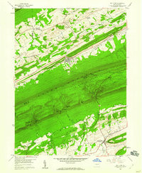
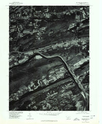
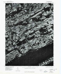 1977 Mexico1979 Print · USGSJuniata County in the late seventies is shown here through detailed aerial imagery of the river valley. Researchers can trace the farm boundaries and small settlements of Mexico, Oakland Mills, and Locust Run along the Juniata River.
 - 1977 Map of Millerstown, 1979 Print
 1977 Millerstown1979 Print · USGSThe Juniata River valley and the surrounding Perry County ridges come to life in this late 1970s aerial survey. Researchers can trace land use patterns and property boundaries near Millerstown, Thompsontown, and the mill site at Donnally Mills.
 - 1984 Map of State College, 1985 Print
 1984 State College1985 Print · USGSCentral Pennsylvania’s Ridge-and-Valley province is captured here in the mid-eighties, showing the deep connection between the mountain terrain and the region's historic settlements. Researchers can trace the layout of Pennsylvania State University and follow old rail corridors like the Bellefonte Historical RR and Conrail.
 - 1988 Map of State College, 1989 Print
 1988 State College1989 Print · USGSCentral Pennsylvania in the late eighties shows the sprawling influence of Pennsylvania State University against a backdrop of ancient ridges. Genealogists can trace family landmarks like Church Hill Church and the Bellefonte Cemetery across the deep valleys.
End of results
Showing maps 1-18 of 18
Top cities near Fayette Township
- Decatur Township historical maps
- Saville Township historical maps
- Newport historical maps
- Middleburg historical maps
- Tuscarora historical maps
- New Bloomfield historical maps
See more
Top neighborhoods of Fayette Township
- Roundtop historical maps
- Cocolamus historical maps
- Swales historical maps
- McAlisterville historical maps
- Oakland Mills historical maps
Frequently asked questions
- What are the different types of historical maps available for Fayette Township?
- What is the oldest map of Fayette Township?
- Where can I purchase historical maps of Fayette Township for my home or office?
- Where can I download high-res historical maps of Fayette Township?
- Are there historical topographic maps available for Fayette Township?
- Is there historical aerial imagery available for Fayette Township?
- Where are historical maps of Fayette Township sourced from?