1950s Maps of Manor Township, Pennsylvania
Explore 11 historic maps of Manor Township from the 1950s. These maps offer a rare glimpse into what life looked like during the 1950s — showing old roads, neighborhoods, homes, and landmarks that have changed or disappeared over time.
Whether you're researching your family's past, planning a metal detecting trip, or studying how Manor Township's landscape evolved across the 1950s, these high-resolution maps are a powerful tool for exploring the history of this region.
- Focus on a specific era: All maps on this page are from the 1950s, giving you a focused view of this time period.
- See what’s changed: Compare century-old streets, trails, and buildings to today's modern landscape using overlays and satellite layers.
- Research with precision: Use these maps for genealogy, historical research, land use analysis, or educational projects.
- View, download, or print: Maps are fully viewable online in high resolution, and can be downloaded or printed for your own records.
Start exploring Manor Township's history through authentic maps from the 1950s. This is your window into the past.
Manor Township, PA maps
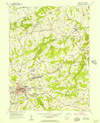
(11)- 1950 Map of Harrisburg, 1952 Print
 1950 Harrisburg1952 Print · USGSMid-century Central Pennsylvania comes alive through its dense rail networks and river valley settlements during the post-war industrial era. Genealogists and historians can trace family roots through hubs like Harrisburg, locate Carlisle Barracks, or follow the Pennsylvania RR through the Lebanon Valley.
 - 1953 Map of Red Lion, 1956 Print
 1953 Red Lion1956 Print · USGSYork County's industrial and rural landscape is captured here in the early fifties as the region's rail network supported growing boroughs and historic furnaces. Researchers can trace family sites at Snavelys Sch, Leiphart Mill, or the historic Canadochly Ch.5 unique versions available
 - 1954 Map of Baltimore
 1954 Baltimore1954 Print · USGSThe Mid-Atlantic region in the early fifties shows a landscape of growing suburban centers and heavy rail corridors. Trace mid-century transit networks and military landmarks from the Aberdeen Proving Ground to the Gettysburg National Military Park.
 - 1955 Map of Conestoga, 1956 Print
 1955 Conestoga1956 Print · USGSLancaster County's southern townships are captured in the mid-fifties, showing a landscape shaped by winding creeks and crossroad villages. Genealogists and historians can trace family roots through numerous country landmarks like Boehm Ch, Marticville, and Colemanville.7 unique versions available
 - 1955 Map of Safe Harbor, 1956 Print
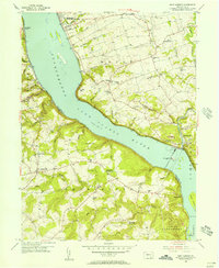 1955 Safe Harbor1956 Print · USGSThe Susquehanna River valley and the engineering of the river for power are seen here in the mid-1950s. Genealogists can trace family roots at Manor Meetinghouse, Bethany Ch, and small crossroads like Washington.7 unique versions available
 - 1956 Map of Baltimore
 1956 Baltimore1956 Print · USGSMid-century Maryland and Pennsylvania are captured here during a period of massive suburban and military growth across the Chesapeake region. Genealogists and historians can trace the rail corridors of the Baltimore & Ohio RR and locate landmarks like Fort McHenry or the Aberdeen Proving Ground.
 - 1956 Map of Columbia East, 1957 Print
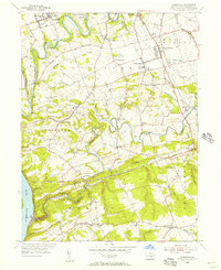
 1956 Columbia East1957 Print · USGSLancaster County's industrial and rural crossroads are captured here in the mid-fifties, showing the heavy rail influence on local growth. Trace family roots and vanished landmarks like McGuinness Airport, St Josephs Academy, and the village of Silver Spring.5 unique versions available
 - 1956 Map of Lancaster, 1958 Print
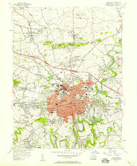 1956 Lancaster1958 Print · USGSMid-century Lancaster and its suburban frontiers are documented here during a period of significant post-war growth. Genealogists and historians can locate family landmarks like the Mennonite Home, Woodward Hill Cemetery, and Franklin and Marshall College.5 unique versions available
 - 1956 Map of Middletown, 1959 Print
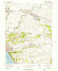
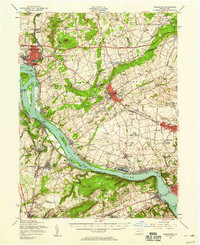 1956 Middletown1959 Print · USGSThe Susquehanna River corridor bustles with Cold War-era industry and riverside life in the mid-1950s. Genealogists and local researchers can trace family landmarks like Shenks Cem, identify regional education hubs such as Elizabethville College, or locate the sprawling Olmsted AFB.2 unique versions available
 - 1957 Map of Harrisburg
 1957 Harrisburg1957 Print · USGSMid-century Central Pennsylvania comes into focus as a bustling network of rail, river, and mountain ridges. Genealogists and historians can trace the development of the State Capitol and surrounding hubs like Middletown, Columbia, and Pottsville.7 unique versions available
 - 1957 Map of Baltimore, 1964 Print
 1957 Baltimore1964 Print · USGSMaryland and Southern Pennsylvania are shown during the mid-century expansion of the Baltimore-Washington corridor. Researchers can trace the extensive rail lines of the Baltimore & Ohio RR and locate sites like Fort Detrick and Gettysburg National Military Park.5 unique versions available
End of results
Showing maps 1-11 of 11
Top cities near Manor Township
- Lancaster historical maps
- West Lampeter Township historical maps
- Ephrata historical maps
- Elizabethtown historical maps
- Columbia historical maps
- Lititz historical maps
See more
Top neighborhoods of Manor Township
- Fairway Park historical maps
- Garden Hills historical maps
- Manor Ridge historical maps
- Letort historical maps
- Central Manor historical maps
- Donerville historical maps
See more
Frequently asked questions
- What are the different types of historical maps available for Manor Township?
- What is the oldest map of Manor Township?
- Where can I purchase historical maps of Manor Township for my home or office?
- Where can I download high-res historical maps of Manor Township?
- Are there historical topographic maps available for Manor Township?
- Is there historical aerial imagery available for Manor Township?
- Where are historical maps of Manor Township sourced from?