1990s Maps of Mount Joy Township, Pennsylvania
Explore 7 historic maps of Mount Joy Township from the 1990s. These maps offer a rare glimpse into what life looked like during the 1990s — showing old roads, neighborhoods, homes, and landmarks that have changed or disappeared over time.
Whether you're researching your family's past, planning a metal detecting trip, or studying how Mount Joy Township's landscape evolved across the 1990s, these high-resolution maps are a powerful tool for exploring the history of this region.
- Focus on a specific era: All maps on this page are from the 1990s, giving you a focused view of this time period.
- See what’s changed: Compare century-old streets, trails, and buildings to today's modern landscape using overlays and satellite layers.
- Research with precision: Use these maps for genealogy, historical research, land use analysis, or educational projects.
- View, download, or print: Maps are fully viewable online in high resolution, and can be downloaded or printed for your own records.
Start exploring Mount Joy Township's history through authentic maps from the 1990s. This is your window into the past.
Mount Joy Township, PA maps
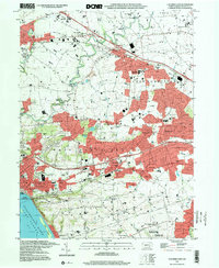
(7)- 1995 Map of Columbia East, 1996 Print
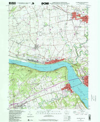
 1995 Columbia East1996 Print · USGSThe Susquehanna River shoreline near Columbia was a hub of transit and community in the mid-1990s. Genealogists and local historians can trace family-named sites and vanished landmarks like Bruckarts Station, Habecker Ch, and Metzgers Indian Cave.
 - 1995 Map of Manheim, 1996 Print
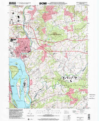
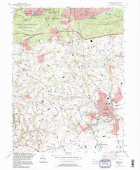 1995 Manheim1996 Print · USGSManheim and the surrounding Lancaster County farmland are captured in the mid-nineties, showing the balance between borough growth and rural tradition. Genealogists and local historians can locate many country landmarks, from Hernley Ch and Fairview Cemetery to the historic Covered Bridge.
 - 1997 Map of Columbia West, 1999 Print
 1997 Columbia West1999 Print · USGSThe Susquehanna River corridor thrives in the late nineties as a hub of rail activity and riverfront industry between Lancaster and York. Genealogists can locate family landmarks like Eberly Cem, Donegal Springs, and schools such as Kraybill Sch.
 - 1997 Map of Manheim, 2000 Print
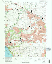
 1997 Manheim2000 Print · USGSManheim and the surrounding Lebanon and Lancaster County borderlands are shown here at the close of the nineties. Genealogists and local historians can trace family-named sites like Gantz Ch and Fairview Cemetery or locate the old rail-and-road crossroads at Lancaster Junction.
 - 1997 Map of Columbia East, 2000 Print
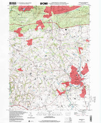
 1997 Columbia East2000 Print · USGSLancaster County at the end of the century reveals a landscape of growing boroughs and deep-rooted rural landmarks between the river and the hills. Researchers can trace family sites at Habecker Ch, locate Bruckarts Station, or explore the riverfront at COLUMBIA.
 - 1999 Map of Middletown, 2001 Print
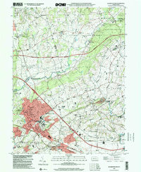
 1999 Middletown2001 Print · USGSThe Lower Susquehanna valley at the turn of the millennium shows a complex mix of industrial infrastructure and rural traditions. Researchers can trace the development of Middletown and Royalton or locate family sites like Stoverdale Ch and Goldsboro (Etters PO).
 - 1999 Map of Elizabethtown, 2001 Print
 1999 Elizabethtown2001 Print · USGSElizabethtown and the fertile borderlands of Lancaster and Dauphin counties are shown here just before the turn of the millennium. Genealogists can trace family names and sites through Oberholtzer Cem, Masonic Sch, and rural villages like Bellaire.
End of results
Showing maps 1-7 of 7
Top cities near Mount Joy Township
- Lancaster historical maps
- York historical maps
- Lebanon historical maps
- Colonial Park historical maps
- Hershey historical maps
- Elizabethtown historical maps
See more
Top neighborhoods of Mount Joy Township
- Aberdeen historical maps
- Anchor historical maps
- Bellaire historical maps
- Beverly historical maps
- Milton Grove historical maps
Frequently asked questions
- What are the different types of historical maps available for Mount Joy Township?
- What is the oldest map of Mount Joy Township?
- Where can I purchase historical maps of Mount Joy Township for my home or office?
- Where can I download high-res historical maps of Mount Joy Township?
- Are there historical topographic maps available for Mount Joy Township?
- Is there historical aerial imagery available for Mount Joy Township?
- Where are historical maps of Mount Joy Township sourced from?