1900-1909 Maps of Lawrence County, Pennsylvania
Explore 9 historic maps of Lawrence County from 1900-1909. These maps offer a rare glimpse into what life looked like during the 1900s — showing old roads, neighborhoods, homes, and landmarks that have changed or disappeared over time.
Whether you're researching your family's past, planning a metal detecting trip, or studying how Lawrence County's landscape evolved across the 1900s, these high-resolution maps are a powerful tool for exploring the history of this region.
- Focus on a specific era: All maps on this page are from the 1900s, giving you a focused view of this time period.
- See what’s changed: Compare century-old streets, trails, and buildings to today's modern landscape using overlays and satellite layers.
- Research with precision: Use these maps for genealogy, historical research, land use analysis, or educational projects.
- View, download, or print: Maps are fully viewable online in high resolution, and can be downloaded or printed for your own records.
Start exploring Lawrence County's history through authentic maps from the 1900s. This is your window into the past.
Lawrence County, PA maps
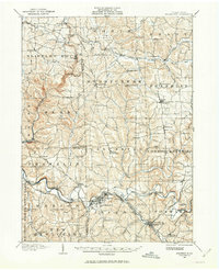
(9)- 1902 Map of New Castle, 1956 Print
 1902 New Castle1956 Print · USGSLawrence and Beaver counties were industrial powerhouses at the turn of the century, defined by a massive intersection of river and rail. Researchers can trace the complex rail networks of the Pennsylvania RR and find historic hubs like New Castle, Ellwood City, and New Galilee.
 - 1904 Map of Newcastle
 1904 Newcastle1904 Print · USGSLawrence and Beaver Counties are captured at a peak of industrial expansion during the early 1900s, when the river valleys were heavy with rail traffic. Genealogists and historians can trace the early footprints of Newcastle, the remote Thompson Run Mines, and the vanished Irish Ripple Newport PO.6 unique versions available
 - 1905 Map of Neshannock, 1960 Print
 1905 Neshannock1960 Print · USGSNear the Pennsylvania-Ohio border after the turn of the century, the river valleys were heavy with steam rail and industry. Researchers can trace historic station stops like Skidmore Eastbrook Sta and local landmarks like the White Chapel or Neshannock Falls.
 - 1906 Map of Youngstown, 1958 Print
 1906 Youngstown1958 Print · USGSThe Mahoning Valley's industrial heartland is caught at its early twentieth-century peak, showing the massive rail and steel infrastructure at the state border. Researchers can trace the lineage of local neighborhoods and schools like Hell Street School, Idora Park, and Tibbetts Corners.
 - 1907 Map of Neshannock
 1907 Neshannock1907 Print · USGSMercer and Lawrence counties are shown here at the height of the steam and electric rail era. Genealogists and local historians can trace family-named landmarks like Books Woods School, Mathews School, and Fayetteville Fay PO.5 unique versions available
 - 1907 Map of Columbiana, 1958 Print
 1907 Columbiana1958 Print · USGSColumbiana County at the turn of the century was a bustling corridor of coal, rail, and community life. Genealogists can trace family names at Subrosa School and Mt Zion Church, or locate defunct stops on the Pennsylvania System.
 - 1908 Map of Youngstown, 1937 Print
 1908 Youngstown1937 Print · USGSThe Mahoning Valley at the height of its industrial boom is defined by a massive concentration of rail lines and riverfront steel towns. Genealogists and historians can trace the footprint of early neighborhood schools like Bell School, find the original layout of Idora Park, and locate vanished rail stops along the ERIE RAILROAD.2 unique versions available
 - 1908 Map of Zelienople, 1963 Print
 1908 Zelienople1963 Print · USGSButler County and parts of Lawrence and Beaver Counties are shown in the first decade of the 1900s, when the region's river-and-rail economy was in full swing. Genealogists and historians can trace family roots at McConnells Mill, locate schools like Tollgate School, or explore the early streets of Zelienople and Harmony.
 - 1909 Map of Columbiana, 1937 Print
 1909 Columbiana1937 Print · USGSThe Ohio-Pennsylvania borderlands are captured here during the peak of the rail era, showing a landscape defined by industry and rural education. Researchers can trace the path of the Pennsylvania System through East Palestine or locate local landmarks like Coalmines and the Subrosa School.2 unique versions available
End of results
Showing maps 1-9 of 9
Top cities of Lawrence County
- New Castle historical maps
- Ellwood City historical maps
- Pulaski Township historical maps
- New Wilmington historical maps
- New Beaver historical maps
- Ellport historical maps
See more
Frequently asked questions
- What are the different types of historical maps available for Lawrence County?
- What is the oldest map of Lawrence County?
- Where can I purchase historical maps of Lawrence County for my home or office?
- Where can I download high-res historical maps of Lawrence County?
- Are there historical topographic maps available for Lawrence County?
- Is there historical aerial imagery available for Lawrence County?
- Where are historical maps of Lawrence County sourced from?