1940s Maps of South Londonderry Township, Pennsylvania
Explore 5 historic maps of South Londonderry Township from the 1940s. These maps offer a rare glimpse into what life looked like during the 1940s — showing old roads, neighborhoods, homes, and landmarks that have changed or disappeared over time.
Whether you're researching your family's past, planning a metal detecting trip, or studying how South Londonderry Township's landscape evolved across the 1940s, these high-resolution maps are a powerful tool for exploring the history of this region.
- Focus on a specific era: All maps on this page are from the 1940s, giving you a focused view of this time period.
- See what’s changed: Compare century-old streets, trails, and buildings to today's modern landscape using overlays and satellite layers.
- Research with precision: Use these maps for genealogy, historical research, land use analysis, or educational projects.
- View, download, or print: Maps are fully viewable online in high resolution, and can be downloaded or printed for your own records.
Start exploring South Londonderry Township's history through authentic maps from the 1940s. This is your window into the past.
South Londonderry Township, PA maps
(5)- 1943 Map of Lancaster
 1943 Lancaster1943 Print · USGSLancaster County at the height of the second World War reveals a landscape defined by bustling rail hubs and thriving farm villages. Genealogists and historians can trace family roots through numerous small hamlets like Brunnerville, industrial sites at Elizabeth Furnace Gap, and recreation spots like Rocky Spring Park.
 - 1943 Map of Lebanon
 1943 Lebanon1943 Print · USGSMid-century Pennsylvania life is captured here during the Second World War, showing the expansion of the Lebanon Valley rail and road networks. Genealogists can locate family landmarks such as the Heidelberg Meeting House, Kimmerlings Ch, and numerous rural schools like Monroe Valley Sch.2 unique versions available
 - 1943 Map of Middletown
 1943 Middletown1943 Print · USGSAs World War II mobilization reached its peak, this survey captures the Susquehanna River corridor as a vital industrial and rail artery. Genealogists and researchers can trace family landmarks like Donegal Springs Church, Codorus Furnace, and the early layout of Three Mile Island.
 - 1943 Map of Hummelstown
 1943 Hummelstown1943 Print · USGSDauphin and Lebanon counties appear here during the Second World War as military and industrial growth transformed the countryside. Researchers can trace family landmarks and rural infrastructure, from Moonshine Ch and Union Deposit to the Hershey Zoo.
 - 1947 Map of Palmyra
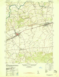 1947 Palmyra1947 Print · USGSLebanon County towns and rural school districts are captured here in the late 1940s as they grew along the Reading railroad. Researchers can trace ancestral locations through numerous named sites like Gravel Hill Church, Meyersville School, and Palmyra Cemetery.2 unique versions available
End of results
Showing maps 1-5 of 5
Top cities near South Londonderry Township
- Lancaster historical maps
- Lebanon historical maps
- Hershey historical maps
- Elizabethtown historical maps
- Columbia historical maps
- Middletown historical maps
See more
Top neighborhoods of South Londonderry Township
- Lawn historical maps
- Upper Lawn historical maps
- Colebrook historical maps
- Timber Hills historical maps
- Mount Wilson historical maps
- Campbelltown historical maps
See more
Frequently asked questions
- What are the different types of historical maps available for South Londonderry Township?
- What is the oldest map of South Londonderry Township?
- Where can I purchase historical maps of South Londonderry Township for my home or office?
- Where can I download high-res historical maps of South Londonderry Township?
- Are there historical topographic maps available for South Londonderry Township?
- Is there historical aerial imagery available for South Londonderry Township?
- Where are historical maps of South Londonderry Township sourced from?