1970s Maps of South Londonderry Township, Pennsylvania
Explore 2 historic maps of South Londonderry Township from the 1970s. These maps offer a rare glimpse into what life looked like during the 1970s — showing old roads, neighborhoods, homes, and landmarks that have changed or disappeared over time.
Whether you're researching your family's past, planning a metal detecting trip, or studying how South Londonderry Township's landscape evolved across the 1970s, these high-resolution maps are a powerful tool for exploring the history of this region.
- Focus on a specific era: All maps on this page are from the 1970s, giving you a focused view of this time period.
- See what’s changed: Compare century-old streets, trails, and buildings to today's modern landscape using overlays and satellite layers.
- Research with precision: Use these maps for genealogy, historical research, land use analysis, or educational projects.
- View, download, or print: Maps are fully viewable online in high resolution, and can be downloaded or printed for your own records.
Start exploring South Londonderry Township's history through authentic maps from the 1970s. This is your window into the past.
South Londonderry Township, PA maps
(2)- 1977 Map of Palmyra, 1979 Print
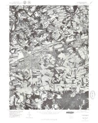 1977 Palmyra1979 Print · USGSCentral Pennsylvania's agricultural heartland is revealed in the late seventies, showing the growing footprint of Palmyra. Genealogists and historians can trace property lines and field patterns near Campbelltown or along the banks of Swatara Creek.
 - 1977 Map of Lebanon, 1979 Print
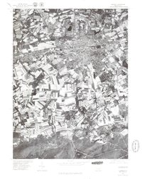 1977 Lebanon1979 Print · USGSLebanon County and its surrounding countryside are captured in this late 1970s aerial survey, showing the transition from urban centers to forested uplands. Trace the developed streets of Lebanon and Cleona or the rural character of Quentin and Cornwall.
End of results
Showing maps 1-2 of 2
Top cities near South Londonderry Township
- Lancaster historical maps
- Lebanon historical maps
- Hershey historical maps
- Elizabethtown historical maps
- Columbia historical maps
- Middletown historical maps
See more
Top neighborhoods of South Londonderry Township
- Lawn historical maps
- Upper Lawn historical maps
- Colebrook historical maps
- Timber Hills historical maps
- Mount Wilson historical maps
- Campbelltown historical maps
See more
Frequently asked questions
- What are the different types of historical maps available for South Londonderry Township?
- What is the oldest map of South Londonderry Township?
- Where can I purchase historical maps of South Londonderry Township for my home or office?
- Where can I download high-res historical maps of South Londonderry Township?
- Are there historical topographic maps available for South Londonderry Township?
- Is there historical aerial imagery available for South Londonderry Township?
- Where are historical maps of South Londonderry Township sourced from?