1940s Maps of Lehigh County, Pennsylvania
Explore 8 historic maps of Lehigh County from the 1940s. These maps offer a rare glimpse into what life looked like during the 1940s — showing old roads, neighborhoods, homes, and landmarks that have changed or disappeared over time.
Whether you're researching your family's past, planning a metal detecting trip, or studying how Lehigh County's landscape evolved across the 1940s, these high-resolution maps are a powerful tool for exploring the history of this region.
- Focus on a specific era: All maps on this page are from the 1940s, giving you a focused view of this time period.
- See what’s changed: Compare century-old streets, trails, and buildings to today's modern landscape using overlays and satellite layers.
- Research with precision: Use these maps for genealogy, historical research, land use analysis, or educational projects.
- View, download, or print: Maps are fully viewable online in high resolution, and can be downloaded or printed for your own records.
Start exploring Lehigh County's history through authentic maps from the 1940s. This is your window into the past.
Lehigh County, PA maps
(8)- 1942 Map of Norristown
 1942 Norristown1942 Print · USGSSoutheastern Pennsylvania at the onset of World War II shows a landscape of busy industrial river towns and expanding rail suburbs. Genealogists and historians can trace the early transit networks connecting Norristown, Doylestown, and the riverfront at New Hope.
 - 1942 Map of Allentown West
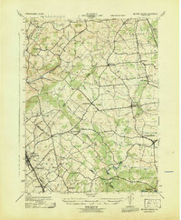
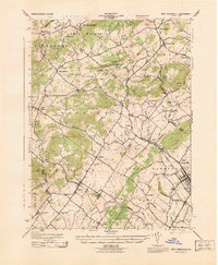
 1942 Allentown West1942 Print · USGSLehigh County during the early war years displays a landscape of industrial river towns and agrarian crossroads. Researchers can locate dozens of country schools like Snyder Sch, historic landmarks like Cedar Crest College, and the sprawling Trexler Game Preserve.3 unique versions available
 - 1943 Map of Mauch Chunk
 1943 Mauch Chunk1943 Print · USGSThe Lehigh River corridor is captured here during the mid-forties, showing the vital rail and industry centers of Carbon County. Genealogists and researchers can trace dozens of rural schoolhouses and family-named landmarks like the Larrytown Poor Farm, St Pauls Ch, and Three O'clock Spring.
 - 1943 Map of Milford Square
 1943 Milford Square1943 Print · USGSSoutheastern Pennsylvania's tri-county borderlands come to life in this mid-century survey. Genealogists can trace family roots through historic hamlets like Mumbauersville, Geryville, and the transit corridor of the Fogelsville Branch rail line.2 unique versions available
 - 1943 Map of East Greenville
 1943 East Greenville1943 Print · USGSSoutheast Pennsylvania at the height of the war years reveals a landscape of dense small settlements and rural industry. Genealogists and historians can trace family roots through the grids of East Greenville and Pennsburg or locate landmarks like Huffs Church and Seisholtzville.
 - 1943 Map of Bethlehem
 1943 Bethlehem1943 Print · USGSNorthampton and Lehigh counties hummed with industry and river commerce during the early war years. Researchers can trace the path of the Lehigh Valley RR, locate family-named landmarks like Chief Tatamy, and find rural schools such as Mexico School and Poplar Valley Sch.
 - 1944 Map of Newark, 1971 Print
 1944 Newark1971 Print · USGSThe industrial corridor from Philadelphia to New York was in a period of massive transition during the mid-forties. Genealogists and researchers can trace the rail lines of the Lehigh Valley RR, locate military installations like Picatinny Arsenal, and explore the early sprawl near Levittown.5 unique versions available
 - 1949 Map of Newark
 1949 Newark1949 Print · USGSThe industrial corridor between Philadelphia and New York comes alive in this post-war survey. Genealogists and historians can trace the massive rail networks of the Reading Railroad and locate major installations like Fort Dix or Picatinny Arsenal.2 unique versions available
End of results
Showing maps 1-8 of 8
Top cities of Lehigh County
- Allentown historical maps
- Emmaus historical maps
- Catasauqua historical maps
- Weisenberg Township historical maps
- Fountain Hill historical maps
- Slatington historical maps
See more
Frequently asked questions
- What are the different types of historical maps available for Lehigh County?
- What is the oldest map of Lehigh County?
- Where can I purchase historical maps of Lehigh County for my home or office?
- Where can I download high-res historical maps of Lehigh County?
- Are there historical topographic maps available for Lehigh County?
- Is there historical aerial imagery available for Lehigh County?
- Where are historical maps of Lehigh County sourced from?