1990s Maps of Bear Creek Junction, Dennison Township
Explore 2 historic maps of Bear Creek Junction from the 1990s. These maps offer a rare glimpse into what life looked like during the 1990s — showing old roads, neighborhoods, homes, and landmarks that have changed or disappeared over time.
Whether you're researching your family's past, planning a metal detecting trip, or studying how Bear Creek Junction's landscape evolved across the 1990s, these high-resolution maps are a powerful tool for exploring the history of this region.
- Focus on a specific era: All maps on this page are from the 1990s, giving you a focused view of this time period.
- See what’s changed: Compare century-old streets, trails, and buildings to today's modern landscape using overlays and satellite layers.
- Research with precision: Use these maps for genealogy, historical research, land use analysis, or educational projects.
- View, download, or print: Maps are fully viewable online in high resolution, and can be downloaded or printed for your own records.
Start exploring Bear Creek Junction's history through authentic maps from the 1990s. This is your window into the past.
Bear Creek Junction, Dennison Township maps
(2)- 1994 Map of White Haven, 1995 Print
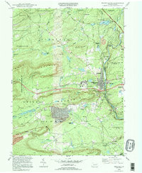 1994 White Haven1995 Print · USGSWhite Haven and the Lehigh Gorge appear in the mid-nineties as a landscape defined by rugged state parks and old industrial corridors. Genealogists and hikers can trace the paths of the old RR grade near Tannery, locate family plots at St Patrick Cem, and explore the lakeside development of Penn Lake Park.
 - 1997 Map of White Haven, 1998 Print
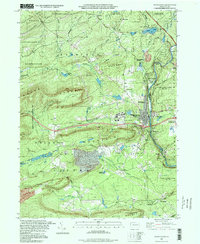 1997 White Haven1998 Print · USGSWhite Haven and the Lehigh Gorge are shown in the late 1990s as the region transitioned from industrial rail hub to a corridor of state parks. Genealogists and researchers can trace local landmarks like St Patrick Cem, the Mountainview Ch, and the operations at Scale Siding.
End of results
Showing maps 1-2 of 2
Top cities near Bear Creek Junction
- Wilkes-Barre historical maps
- Hazleton historical maps
- Kingston historical maps
- Nanticoke historical maps
- Plains Township historical maps
- Dallas Township historical maps
See more
Frequently asked questions
- What are the different types of historical maps available for Bear Creek Junction?
- What is the oldest map of Bear Creek Junction?
- Where can I purchase historical maps of Bear Creek Junction for my home or office?
- Where can I download high-res historical maps of Bear Creek Junction?
- Are there historical topographic maps available for Bear Creek Junction?
- Is there historical aerial imagery available for Bear Creek Junction?
- Where are historical maps of Bear Creek Junction sourced from?