Old Maps of Foster Township, Pennsylvania
Explore 69 old maps of Foster Township, spanning from 1889 to today. These high-resolution historic maps reveal how streets, neighborhoods, landmarks, and natural features evolved over time — perfect for genealogy, metal detecting, research, and local history exploration.
What you can do with these maps:
- See how Foster Township changed over time: Compare historical maps to modern-day views to trace roads, homesites, rail lines & more.
- View detailed metadata: Each map includes creators, publishers, year, scale, and archive source.
- Overlay maps with satellite & LiDAR: Visualize the past alongside modern tools to explore terrain & human change.
- Trusted historical sources: Maps sourced from the USGS, Library of Congress, and other archives.
- Access maps your way: View online, download high-res files, or order prints for personal or research use.
Start exploring old maps of Foster Township to uncover forgotten places, hidden landmarks, and the deep history beneath your feet.
Foster Township, PA maps
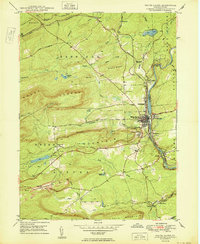
(69)- 1889 Map of Hazleton, 1956 Print
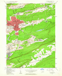
 1889 Hazleton1956 Print · USGSThe Pennsylvania coal fields are seen at their industrial height in the late 1880s, revealing a landscape defined by anthracite and iron rails. Genealogists and historians can trace the early footprints of Hazleton, the company town of Eckley, and the rail-heavy corridors of Lansford and Tamaqua.
 - 1891 Map of Wilkesbarre
 1891 Wilkesbarre1891 Print · USGSLuzerne County's industrial heartland is caught here at the height of the anthracite era, where the coal-and-rail economy dominated the Wyoming Valley. Genealogists and historians can trace the specific layouts of coal patches like Sugar Notch and Moffatt Patch or follow the path of the Lehigh Valley R. R. across the ridges.2 unique versions available
 - 1891 Map of Hazleton
 1891 Hazleton1891 Print · USGSThe anthracite coal region comes alive in the late nineteenth century, showing a landscape defined by ridges and rail lines. Genealogists and historians can trace the early footprints of Hazleton, the gravity-rail heritage at Summit Hill, and the bustling yards of Lansford or Tamaqua.
 - 1893 Map of Hazleton
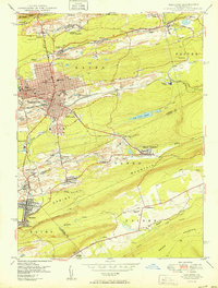
 1893 Hazleton1893 Print · USGSThe anthracite coal region of Northeastern Pennsylvania is captured here in the late nineteenth century, during its industrial peak. Genealogists and historians can trace the early rail networks and company patches like Lansford, Summit Hill, and the coal-rich village of Eckley.8 unique versions available
 - 1894 Map of Wilkesbarre
 1894 Wilkesbarre1894 Print · USGSThe northern anthracite coal fields and rugged ridge-and-valley terrain of Luzerne County are captured here in the 1890s. Researchers can trace early railroad alignments through Sugar Notch or locate long-standing settlements like White Haven and Ashley.8 unique versions available
 - 1922 Map of Stoddartsville, 1958 Print
 1922 Stoddartsville1958 Print · USGSThe Pennsylvania Poconos at the turn of the century show a landscape of high timber ridges and early mountain resorts. Genealogists and hikers can trace the original paths to Stoddartsville, identify the old Fayette School, or follow the Wilkes-Barre and Eastern rail line.2 unique versions available
 - 1924 Map of Stoddartsville
 1924 Stoddartsville1924 Print · USGSUpper Carbon and Monroe counties are shown in the early twenties as a landscape of timbered hills and headwater streams. Genealogists can locate old rural landmarks like Bradys Switch, the Leonardsville settlement, and the Locust Ridge School.5 unique versions available
 - 1943 Map of Scranton
 1943 Scranton1943 Print · USGSNortheastern Pennsylvania’s coal and rail corridor comes to life in the 1940s, showcasing the dense urban industrial centers of the Wyoming Valley. Genealogists can locate family landmarks like the Fayette School and Locust Ridge School or trace the early paths of the DL & W and Erie railroads.
 - 1943 Map of Stoddartsville
 1943 Stoddartsville1943 Print · USGSThe Pocono Plateau at the height of the Second World War shows a landscape defined by river valleys and developing recreation preserves. Genealogists and local historians can trace rural schoolhouses and small settlements like Stoddartsville, Albrightsville, and the Fishery Sch.
 - 1944 Map of Newark, 1971 Print
 1944 Newark1971 Print · USGSThe industrial corridor from Philadelphia to New York was in a period of massive transition during the mid-forties. Genealogists and researchers can trace the rail lines of the Lehigh Valley RR, locate military installations like Picatinny Arsenal, and explore the early sprawl near Levittown.5 unique versions available
 - 1947 Map of Hazleton, 1962 Print
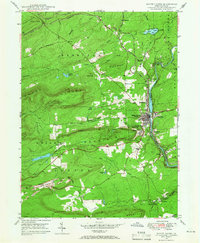
 1947 Hazleton1962 Print · USGSThe Pennsylvania coal fields and the industrial hubs of Luzerne County are captured here just after the war. Researchers can trace the rail-and-mine landscape of Ashmore Yards, Lattimer Mines, and the borough of McAdoo.5 unique versions available
 - 1947 Map of White Haven, 1966 Print
 1947 White Haven1966 Print · USGSThe Lehigh River valley in the late 1940s is a landscape defined by industry and rail, where coal mining and transportation intersect. Genealogists can trace family roots through settlements like White Haven and Tannery, or locate local landmarks like Ripple Sch and St Patrick Cem.4 unique versions available
 - 1948 Map of Weatherly, 1965 Print
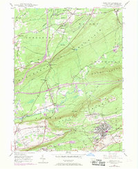
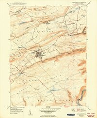
 1948 Weatherly1965 Print · USGSDeep in the anthracite region after the war, this map shows the mining and rail networks of Carbon and Luzerne counties. Trace the coal heritage of Eckley and Weatherly, or locate local landmarks like St Joseph Ch and Larrytown Sch.6 unique versions available
 - 1948 Map of Freeland, 1969 Print
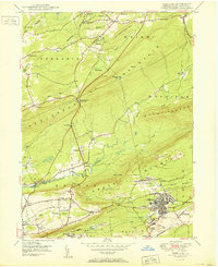
 1948 Freeland1969 Print · USGSLuzerne County's anthracite region is captured here during a period of industrial change after the war. Local historians can trace the development of Freeland and Upper Lehigh alongside the rail networks of the Central RR of New Jersey and the Lehigh Valley RR.3 unique versions available
 - 1949 Map of Newark
 1949 Newark1949 Print · USGSThe industrial corridor between Philadelphia and New York comes alive in this post-war survey. Genealogists and historians can trace the massive rail networks of the Reading Railroad and locate major installations like Fort Dix or Picatinny Arsenal.2 unique versions available
 - 1950 Map of White Haven
 1950 White Haven1950 Print · USGSThe industrial Lehigh River corridor is captured here just after the war, showing the vital rail and mining networks of the day. Researchers can trace family sites at White Haven or Pond Creek, and locate features like the Ripple Sch and Jefferson Hospital.2 unique versions available
 - 1950 Map of Hazleton
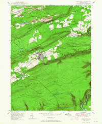
 1950 Hazleton1950 Print · USGSThe anthracite coal region of Pennsylvania comes into sharp focus during the post-war era. Researchers can trace the extensive rail networks of the Lehigh Valley and identify localized mining communities like Lattimer Mines (PO) and Coxes Village.2 unique versions available
 - 1950 Map of Freeland
 1950 Freeland1950 Print · USGSLuzerne County's anthracite country is documented here in the mid-century, showing the intensive mining operations and rail networks around the borough of Freeland. Researchers can trace the industrial landscape of Upper Lehigh or locate local landmarks like Honey Hole, Kis-Lyn, and St Ann Cem.2 unique versions available
 - 1950 Map of Weatherly
 1950 Weatherly1950 Print · USGSWeatherly and the surrounding anthracite coal fields are documented here in the late 1940s as industry and local life intertwined. Genealogists and historians can trace family locations near St Joseph Ch, the Larrytown Sch, and the old company town at Eckley.2 unique versions available
 - 1950 Map of Scranton, 1952 Print
 1950 Scranton1952 Print · USGSMid-century Northeast Pennsylvania and the Hudson Valley come alive in this survey of the tri-state region. Genealogists and historians can trace the dense rail networks of the Erie RR and DL&W RR between industrial hubs like Scranton and Wilkes-Barre.
 - 1953 Map of Scranton
 1953 Scranton1953 Print · USGSNortheastern Pennsylvania and the Catskills are shown in great detail during the early fifties, a time when rail lines and river valleys dictated the region's growth. Genealogists and historians can trace the industrial hearts of Scranton and Wilkes-Barre or locate remote landmarks like High Point and Lake Wallenpaupack.
 - 1956 Map of Newark
 1956 Newark1956 Print · USGSThe industrial heart of the Mid-Atlantic is captured here at the dawn of the highway era, tracing the dense corridors between Newark and Philadelphia. Genealogists and local historians can map the rail networks of the Reading RR or locate mid-century military life at Fort Dix Military Reservation.2 unique versions available
 - 1957 Map of Newark
 1957 Newark1957 Print · USGSThe industrial and military heart of the Mid-Atlantic is mapped during its post-war suburban boom. Genealogists and historians can trace the intricate rail corridors of the Reading Railroad and locate key landmarks from Princeton University to Fort Hancock.
 - 1959 Map of Scranton
 1959 Scranton1959 Print · USGSThe northern coalfields and the Hudson Valley meet in this mid-century survey of the Pennsylvania and New York borderlands. Genealogists and historians can trace the intricate rail networks of the Erie Railroad and the vast waters of Lake Wallenpaupack.2 unique versions available
 - 1960 Map of Newark
 1960 Newark1960 Print · USGSThe industrial heart of the Mid-Atlantic is shown at mid-century, stretching from the dense urban centers of Newark and Philadelphia to the Blue Mountain ridges. Researchers can trace historic rail lines, coastal defenses at Fort Hancock, and the riverfront growth of Trenton and Easton.3 unique versions available
Showing maps 1-25 of 69
Top cities near Foster Township
- Wilkes-Barre historical maps
- Hazleton historical maps
- Nanticoke historical maps
- Plains Township historical maps
- Tamaqua historical maps
- Palmerton historical maps
See more
Top neighborhoods of Foster Township
- Upper Lehigh historical maps
- Woodside historical maps
- Hazlebrook historical maps
- Highland historical maps
- Hickory Hills historical maps
- Pond Creek historical maps
See more
Frequently asked questions
- What are the different types of historical maps available for Foster Township?
- What is the oldest map of Foster Township?
- Where can I purchase historical maps of Foster Township for my home or office?
- Where can I download high-res historical maps of Foster Township?
- Are there historical topographic maps available for Foster Township?
- Is there historical aerial imagery available for Foster Township?
- Where are historical maps of Foster Township sourced from?