1970s Maps of Kingston, Luzerne County
Explore 2 historic maps of Kingston from the 1970s. These maps offer a rare glimpse into what life looked like during the 1970s — showing old roads, neighborhoods, homes, and landmarks that have changed or disappeared over time.
Whether you're researching your family's past, planning a metal detecting trip, or studying how Kingston's landscape evolved across the 1970s, these high-resolution maps are a powerful tool for exploring the history of this region.
- Focus on a specific era: All maps on this page are from the 1970s, giving you a focused view of this time period.
- See what’s changed: Compare century-old streets, trails, and buildings to today's modern landscape using overlays and satellite layers.
- Research with precision: Use these maps for genealogy, historical research, land use analysis, or educational projects.
- View, download, or print: Maps are fully viewable online in high resolution, and can be downloaded or printed for your own records.
Start exploring Kingston's history through authentic maps from the 1970s. This is your window into the past.
Kingston, Luzerne County maps
(2)- 1976 Map of Pittston, 1979 Print
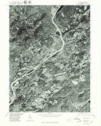 1976 Pittston1979 Print · USGSThe Wyoming Valley comes into sharp focus in the mid-1970s, showcasing the urban density along the Susquehanna River. Trace the industrial footprint of Pittston and Wilkes-Barre or locate family properties in Swoyersville.
 - 1976 Map of Kingston, 1979 Print
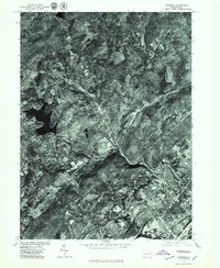 1976 Kingston1979 Print · USGSIn the mid-seventies, the Pennsylvania coal-country settlements along the Susquehanna River maintained a dense, traditional footprint. Genealogists and local historians can trace the street grids and land use of Kingston, Edwardsville, and Swoyersville at this specific moment in time.
End of results
Showing maps 1-2 of 2
Frequently asked questions
- What are the different types of historical maps available for Kingston?
- What is the oldest map of Kingston?
- Where can I purchase historical maps of Kingston for my home or office?
- Where can I download high-res historical maps of Kingston?
- Are there historical topographic maps available for Kingston?
- Is there historical aerial imagery available for Kingston?
- Where are historical maps of Kingston sourced from?