1900s (20th Century) Maps of Ross Township, Pennsylvania
Explore 22 historic maps of Ross Township from the 1900s (20th Century). These maps offer a rare glimpse into what life looked like during the 1900s — showing old roads, neighborhoods, homes, and landmarks that have changed or disappeared over time.
Whether you're researching your family's past, planning a metal detecting trip, or studying how Ross Township's landscape evolved across the 1900s, these high-resolution maps are a powerful tool for exploring the history of this region.
- Focus on a specific era: All maps on this page are from the 1900s, giving you a focused view of this time period.
- See what’s changed: Compare century-old streets, trails, and buildings to today's modern landscape using overlays and satellite layers.
- Research with precision: Use these maps for genealogy, historical research, land use analysis, or educational projects.
- View, download, or print: Maps are fully viewable online in high resolution, and can be downloaded or printed for your own records.
Start exploring Ross Township's history through authentic maps from the 1900s. This is your window into the past.
Ross Township, PA maps
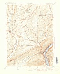
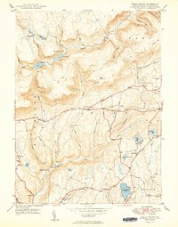
(22)- 1934 Map of Laporte
 1934 Laporte1934 Print · USGSSullivan County in the early thirties was a landscape of timber camps and coal towns connected by the Lehigh Valley railroad. Genealogists and local historians can trace family locations through old landmarks like Richards Grove, the Sugarloaf Sch, and Jamison City.3 unique versions available
 - 1946 Map of Shickshinny
 1946 Shickshinny1946 Print · USGSLuzerne County's river-and-ridge landscape is captured here in the mid-1940s, as the Pennsylvania railroad follows the Susquehanna River through the mountains. Genealogists can trace family names at the Sorber Cemetery or locate old schoolhouses like Sunshine School and McKendree School.2 unique versions available
 - 1946 Map of Dutch Mtn, 1960 Print
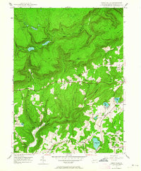
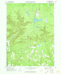
 1946 Dutch Mtn1960 Print · USGSThe high plateau of Wyoming and Sullivan counties is captured here in the years following the war, showing a landscape defined by deep creek gorges and remote settlements. Researchers can locate the Fincke Cem, the Bellasylva settlement, and the old Ricketts Fire Tower.3 unique versions available
 - 1946 Map of Harveys Lake, 1962 Print
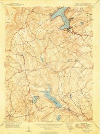
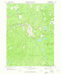
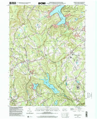
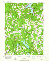 1946 Harveys Lake1962 Print · USGSLuzerne County's Back Mountain region appears here in the mid-1940s, characterized by its deep glacial lakes and highland ridges. Researchers can locate vanished landmarks like the Santee Sch, Wordan Place, and numerous family burial grounds including Kocher Cem.5 unique versions available
 - 1946 Map of Sweet Valley, 1964 Print
 1946 Sweet Valley1964 Print · USGSLuzerne County in the mid-1940s reveals a landscape of ridge-top forests and valley settlements like Sweet Valley and Kyttle. Researchers can locate historic rural institutions including Bethel Ch, Retreat Sch, and the Splash Dam at Mountain Springs.4 unique versions available
 - 1948 Map of Dutch Mtn
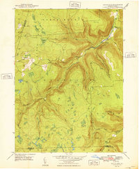 1948 Dutch Mtn1948 Print · USGSThe Pennsylvania highlands north of Ricketts Glen come into focus in the 1940s, showing a remote landscape of steep mountain brooks and high-plateau clearings. Researchers can locate the mountain settlement at Bellasylva, the Fincke Cem, and the Ricketts Fire Tower.2 unique versions available
 - 1949 Map of Sweet Valley
 1949 Sweet Valley1949 Print · USGSNorthwestern Luzerne County is captured here in the late 1940s, showing a rugged landscape of water management and rural hamlets. Researchers can trace the layout of small schoolhouses and country churches like Mott School, Bethel Church, and Hetley Grove Ch.2 unique versions available
 - 1949 Map of Harvey Lake
 1949 Harvey Lake1949 Print · USGSLuzerne County's lake country is captured here during the late 1940s, showing the early development of resort and rural life. Genealogists can trace family names through landmarks like Wordan Place, Laketon, and the St Anns Cem.2 unique versions available
 - 1953 Map of LaPorte, 1956 Print
 1953 LaPorte1956 Print · USGSSullivan County's plateau country is captured here during the early 1950s, showing a landscape of small coal towns and growing state parks. Researchers can find many rural landmarks, including Painter Mills, Sugarloaf Sch, and the high waters of Ganoga Lake.3 unique versions available
 - 1954 Map of Williamsport
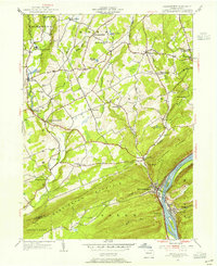
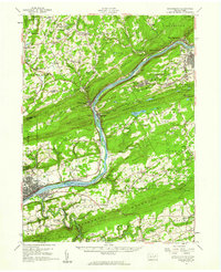
 1954 Williamsport1954 Print · USGSNorth-central Pennsylvania in the mid-fifties is defined by the winding West Branch Susquehanna River and its industrial valley. Local historians can trace the massive Susquehanna Ordnance Depot and the extensive rail networks of the Pennsylvania Railroad.
 - 1954 Map of Shickshinny, 1955 Print
 1954 Shickshinny1955 Print · USGSLuzerne County's river-and-mountain landscape is captured here in the mid-1950s, centered on the borough of Shickshinny and its crossing to Mocanaqua. Researchers can trace rural life through landmarks like Patterson Grove, the Lower Muhlenburg Ch, and the Pennsylvania rail line.5 unique versions available
 - 1955 Map of Shickshinny, 1960 Print
 1955 Shickshinny1960 Print · USGSThe Susquehanna River valley and the anthracite coal region appear in fine detail during the mid-fifties. Researchers can trace old rail corridors, family cemeteries like St Alberts Cem, and smaller settlements such as Mocanaqua or Patterson Grove.
 - 1960 Map of Williamsport
 1960 Williamsport1960 Print · USGSNorth-central Pennsylvania in the mid-twentieth century was a vital corridor of rail and river industry stretching from the New York line to the coal regions. Genealogists can trace the rail networks of the Pennsylvania RR and Lehigh Valley RR connecting towns like Williamsport, Towanda, and Lock Haven.
 - 1962 Map of Williamsport, 1966 Print
 1962 Williamsport1966 Print · USGSNorth-central Pennsylvania was a landscape of industrial river hubs and vast state woodlands in the early sixties. Researchers can trace the path of the Pennsylvania Railroad through Williamsport and explore the remote reaches of Bucktail State Park.5 unique versions available
 - 1965 Map of Williamsport
 1965 Williamsport1965 Print · USGSNorth-central Pennsylvania in the mid-1960s is defined by the industrial river towns and vast timberlands of the Allegheny Plateau. Researchers can trace historic rail lines like the Erie Lackawanna and Reading as they thread through Williamsport, Lock Haven, and Jersey Shore.
 - 1966 Map of Williamsport
 1966 Williamsport1966 Print · USGSThe Susquehanna Valley was a hub of transit and industry in the mid-seventies, where the river's West Branch connected major college towns and timberlands. Researchers can trace historical rail lines like the Reading or locate regional landmarks from Jersey Shore to Ricketts Glen State Park.
 - 1969 Map of Red Rock, 1973 Print
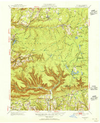
 1969 Red Rock1973 Print · USGSThe high plateau of the Endless Mountains is captured in the late sixties, showing the Cold War presence of the Benton Air Force Station. Genealogists and historians can trace the remote settlements of Jamison City, Central, and Mossville alongside the waterfalls of Ricketts Glen State Park.4 unique versions available
 - 1969 Map of Lopez, 1973 Print
 1969 Lopez1973 Print · USGSSullivan County’s high plateaus and creek valleys are captured here in the late sixties as conservation lands began to surround older industrial sites. Researchers can trace the Old Railroad Grade near Lopez or locate family sites at St Vladimirs Cem and Murray.5 unique versions available
 - 1984 Map of Williamsport East, 1985 Print
 1984 Williamsport East1985 Print · USGSThe Susquehanna River valley and Allegheny highlands come together in this mid-eighties survey of central Pennsylvania. Trace family roots at Muncy Cem or locate institutional landmarks like Lycoming College and the State Correctional Institution at Retreat.2 unique versions available
 - 1995 Map of Red Rock, 1998 Print
 1995 Red Rock1998 Print · USGSThe high plateau where Sullivan, Luzerne, and Columbia counties converge was a hub of timbering and mountain recreation in the mid-nineties. Trace the path of the Old Railroad Grade or locate the Covered Bridge near historical settlements like Jamison City and Tri Mills.
 - 1997 Map of Dutch Mtn, 1999 Print
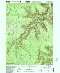 1997 Dutch Mtn1999 Print · USGSThe high-plateau wilderness of the Endless Mountains is captured here in the late nineties. Genealogists and hikers can trace the geography around Bellasylva, locate the Ricketts Fire Tower, and explore the wetlands of Crane Swamp.
 - 1999 Map of Harveys Lake, 2001 Print
 1999 Harveys Lake2001 Print · USGSLuzerne County's uplands are captured here at the end of the century, showing a landscape defined by the waters of Harveys Lake and Pikes Creek Reservoir. Researchers can trace local history through sites like Wordan Place, St Anns Cem, and the Rock Sch.
End of results
Showing maps 1-22 of 22
Top cities near Ross Township
- Nanticoke historical maps
- Berwick historical maps
- Dallas Township historical maps
- Kingston Township historical maps
- Lehman Township historical maps
- Harveys Lake historical maps
See more
Top neighborhoods of Ross Township
- Sweet Valley historical maps
- Weintz historical maps
- Bloomingdale historical maps
- Broadway historical maps
- Kyttle historical maps
Frequently asked questions
- What are the different types of historical maps available for Ross Township?
- What is the oldest map of Ross Township?
- Where can I purchase historical maps of Ross Township for my home or office?
- Where can I download high-res historical maps of Ross Township?
- Are there historical topographic maps available for Ross Township?
- Is there historical aerial imagery available for Ross Township?
- Where are historical maps of Ross Township sourced from?