Old Maps of West Hazleton, Luzerne County for Academic Research
Study the evolution of West Hazleton with 26 high-resolution historic maps. Whether you're teaching, researching, or modeling changes in land use, these maps provide essential visual documentation of urban, environmental, and geographic change.
- Analyze long-term change: Track patterns in development, transportation, and natural features.
- Ideal for environmental or urban studies: Support academic projects with primary historical map data.
- Use in the classroom or lab: Educators and researchers rely on these maps to bring historical context to life.
These maps are a powerful tool for teaching, research, and visualizing how West Hazleton has changed over the decades.
West Hazleton, Luzerne County maps
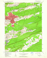
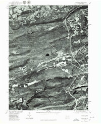
(26)- 1889 Map of Hazleton, 1956 Print
 1889 Hazleton1956 Print · USGSCovers West Hazleton, including Hazleton, Tamaqua, and other nearby areas
 - 1891 Map of Hazleton
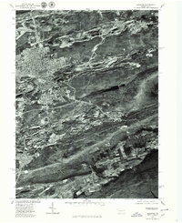
 1891 Hazleton1891 Print · USGSCovers West Hazleton, including Hazleton, Tamaqua, and other nearby areas
 - 1892 Map of Mahanoy
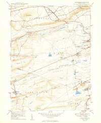
 1892 Mahanoy1892 Print · USGSCovers West Hazleton, including Shenandoah, Mahanoy City, and other nearby areas
 - 1893 Map of Hazleton
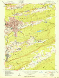
 1893 Hazleton1893 Print · USGSCovers West Hazleton, including Hazleton, Tamaqua, and other nearby areas8 unique versions available
 - 1893 Map of Mahanoy, 1898 Print
 1893 Mahanoy1898 Print · USGSCovers West Hazleton, including Shenandoah, Mahanoy City, and other nearby areas7 unique versions available
 - 1944 Map of Newark, 1971 Print
 1944 Newark1971 Print · USGSCovers West Hazleton, including New York, Philadelphia, and other nearby areas5 unique versions available
 - 1947 Map of Hazleton, 1962 Print
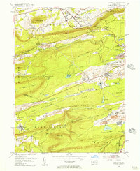
 1947 Hazleton1962 Print · USGSCovers West Hazleton, including Hazleton, McAdoo, and other nearby areas5 unique versions available
 - 1949 Map of Newark
 1949 Newark1949 Print · USGSCovers West Hazleton, including New York, Philadelphia, and other nearby areas3 unique versions available
 - 1949 Map of Conyngham
 1949 Conyngham1949 Print · USGSCovers West Hazleton, including Conyngham, Sheppton, and other nearby areas2 unique versions available
 - 1950 Map of Hazleton
 1950 Hazleton1950 Print · USGSCovers West Hazleton, including Hazleton, McAdoo, and other nearby areas2 unique versions available
 - 1950 Map of Harrisburg, 1952 Print
 1950 Harrisburg1952 Print · USGSCovers West Hazleton, including Lancaster, Harrisburg, and other nearby areas
 - 1955 Map of Conyngham, 1956 Print
 1955 Conyngham1956 Print · USGSCovers West Hazleton, including Conyngham, Sheppton, and other nearby areas6 unique versions available
 - 1955 Map of Mahanoy, 1960 Print
 1955 Mahanoy1960 Print · USGSCovers West Hazleton, including Shenandoah, Mahanoy City, and other nearby areas
 - 1956 Map of Newark
 1956 Newark1956 Print · USGSCovers West Hazleton, including New York, Philadelphia, and other nearby areas2 unique versions available
 - 1957 Map of Harrisburg
 1957 Harrisburg1957 Print · USGSCovers West Hazleton, including Lancaster, Harrisburg, and other nearby areas7 unique versions available
 - 1957 Map of Newark
 1957 Newark1957 Print · USGSCovers West Hazleton, including New York, Philadelphia, and other nearby areas
 - 1960 Map of Newark
 1960 Newark1960 Print · USGSCovers West Hazleton, including New York, Philadelphia, and other nearby areas3 unique versions available
 - 1961 Map of Harrisburg
 1961 Harrisburg1961 Print · USGSCovers West Hazleton, including Lancaster, Harrisburg, and other nearby areas2 unique versions available
 - 1964 Map of Newark
 1964 Newark1964 Print · USGSCovers West Hazleton, including New York, Philadelphia, and other nearby areas2 unique versions available
 - 1964 Map of Harrisburg
 1964 Harrisburg1964 Print · USGSCovers West Hazleton, including Lancaster, Harrisburg, and other nearby areas
 - 1976 Map of Conyngham, 1979 Print
 1976 Conyngham1979 Print · USGSCovers West Hazleton, including Conyngham, Sheppton, and other nearby areas
 - 1976 Map of Hazleton, 1979 Print
 1976 Hazleton1979 Print · USGSCovers West Hazleton, including Hazleton, McAdoo, and other nearby areas
 - 1984 Map of Allentown, 1985 Print
 1984 Allentown1985 Print · USGSCovers West Hazleton, including Allentown, Bethlehem, and other nearby areas3 unique versions available
 - 1984 Map of Sunbury, 1985 Print
 1984 Sunbury1985 Print · USGSCovers West Hazleton, including Bloomsburg, Pottsville, and other nearby areas2 unique versions available
 - 1995 Map of Hazleton, 1996 Print
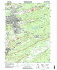 1995 Hazleton1996 Print · USGSCovers West Hazleton, including Hazleton, McAdoo, and other nearby areas
Showing maps 1-25 of 26
Frequently asked questions
- What are the different types of historical maps available for West Hazleton?
- What is the oldest map of West Hazleton?
- Where can I purchase historical maps of West Hazleton for my home or office?
- Where can I download high-res historical maps of West Hazleton?
- Are there historical topographic maps available for West Hazleton?
- Is there historical aerial imagery available for West Hazleton?
- Where are historical maps of West Hazleton sourced from?