1970s Maps of Wilkes-Barre, Pennsylvania
Explore 4 historic maps of Wilkes-Barre from the 1970s. These maps offer a rare glimpse into what life looked like during the 1970s — showing old roads, neighborhoods, homes, and landmarks that have changed or disappeared over time.
Whether you're researching your family's past, planning a metal detecting trip, or studying how Wilkes-Barre's landscape evolved across the 1970s, these high-resolution maps are a powerful tool for exploring the history of this region.
- Focus on a specific era: All maps on this page are from the 1970s, giving you a focused view of this time period.
- See what’s changed: Compare century-old streets, trails, and buildings to today's modern landscape using overlays and satellite layers.
- Research with precision: Use these maps for genealogy, historical research, land use analysis, or educational projects.
- View, download, or print: Maps are fully viewable online in high resolution, and can be downloaded or printed for your own records.
Start exploring Wilkes-Barre's history through authentic maps from the 1970s. This is your window into the past.
Wilkes-Barre, PA maps
(4)- 1976 Map of Wilkes-Barre East, 1979 Print
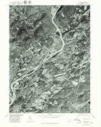
 1976 Wilkes-Barre East1979 Print · USGSWilkes-Barre and the surrounding highlands are captured in this mid-seventies aerial survey as the city meets the mountain. Local historians can trace the development of Forest Park and Glen Summit against the terrain of Wyoming Mountain.
 - 1976 Map of Wilkes-Barre West, 1979 Print
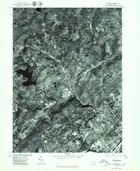
 1976 Wilkes-Barre West1979 Print · USGSThe Wyoming Valley's industrial corridor comes into focus in the late 1970s, showing the dense riverside development of the coal region. Trace the layout of boroughs like Plymouth and Sugar Notch or the high ridges of Penobscot Mountain.
 - 1976 Map of Pittston, 1979 Print
 1976 Pittston1979 Print · USGSThe Wyoming Valley comes into sharp focus in the mid-1970s, showcasing the urban density along the Susquehanna River. Trace the industrial footprint of Pittston and Wilkes-Barre or locate family properties in Swoyersville.
 - 1976 Map of Kingston, 1979 Print
 1976 Kingston1979 Print · USGSIn the mid-seventies, the Pennsylvania coal-country settlements along the Susquehanna River maintained a dense, traditional footprint. Genealogists and local historians can trace the street grids and land use of Kingston, Edwardsville, and Swoyersville at this specific moment in time.
End of results
Showing maps 1-4 of 4
Top cities near Wilkes-Barre
- Scranton historical maps
- Kingston historical maps
- Nanticoke historical maps
- Plains Township historical maps
- Dallas Township historical maps
- Old Forge historical maps
See more
Top neighborhoods of Wilkes-Barre
- Parsons historical maps
- Goose Island historical maps
- Mayflower historical maps
- Mayflower historical maps
- Rolling Mill Hill historical maps
- Parsons historical maps
See more
Frequently asked questions
- What are the different types of historical maps available for Wilkes-Barre?
- What is the oldest map of Wilkes-Barre?
- Where can I purchase historical maps of Wilkes-Barre for my home or office?
- Where can I download high-res historical maps of Wilkes-Barre?
- Are there historical topographic maps available for Wilkes-Barre?
- Is there historical aerial imagery available for Wilkes-Barre?
- Where are historical maps of Wilkes-Barre sourced from?