1990s Maps of Texas, Pine Township
Explore 1 historic maps of Texas from the 1990s. These maps offer a rare glimpse into what life looked like during the 1990s — showing old roads, neighborhoods, homes, and landmarks that have changed or disappeared over time.
Whether you're researching your family's past, planning a metal detecting trip, or studying how Texas's landscape evolved across the 1990s, these high-resolution maps are a powerful tool for exploring the history of this region.
- Focus on a specific era: All maps on this page are from the 1990s, giving you a focused view of this time period.
- See what’s changed: Compare century-old streets, trails, and buildings to today's modern landscape using overlays and satellite layers.
- Research with precision: Use these maps for genealogy, historical research, land use analysis, or educational projects.
- View, download, or print: Maps are fully viewable online in high resolution, and can be downloaded or printed for your own records.
Start exploring Texas's history through authentic maps from the 1990s. This is your window into the past.
Texas, Pine Township maps
(1)- 1994 Map of Morris, 1999 Print
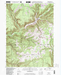 1994 Morris1999 Print · USGSThe Pennsylvania backcountry near the Tioga and Lycoming border is captured here in the 1990s, centered on the valley hamlets of Morris and Hoytville. Researchers can trace old mountain roads and local landmarks like Lewis Cem and the Crawford Fire Tower.
End of results
Showing maps 1-1 of 1
Top cities near Texas
- Wellsboro historical maps
- Blossburg historical maps
- Covington historical maps
- Morris Township historical maps
- Gallagher Township historical maps
- Liberty historical maps
See more
Frequently asked questions
- What are the different types of historical maps available for Texas?
- What is the oldest map of Texas?
- Where can I purchase historical maps of Texas for my home or office?
- Where can I download high-res historical maps of Texas?
- Are there historical topographic maps available for Texas?
- Is there historical aerial imagery available for Texas?
- Where are historical maps of Texas sourced from?