2020s Maps of Plunketts Creek Township, Pennsylvania
Explore 5 historic maps of Plunketts Creek Township from the 2020s. These maps offer a rare glimpse into what life looked like during the 2020s — showing old roads, neighborhoods, homes, and landmarks that have changed or disappeared over time.
Whether you're researching your family's past, planning a metal detecting trip, or studying how Plunketts Creek Township's landscape evolved across the 2020s, these high-resolution maps are a powerful tool for exploring the history of this region.
- Focus on a specific era: All maps on this page are from the 2020s, giving you a focused view of this time period.
- See what’s changed: Compare century-old streets, trails, and buildings to today's modern landscape using overlays and satellite layers.
- Research with precision: Use these maps for genealogy, historical research, land use analysis, or educational projects.
- View, download, or print: Maps are fully viewable online in high resolution, and can be downloaded or printed for your own records.
Start exploring Plunketts Creek Township's history through authentic maps from the 2020s. This is your window into the past.
Plunketts Creek Township, PA maps
(5)- 2023 Map of Huntersville, 2023 Print
 2023 Huntersville2023 Print · USGSLycoming County’s ridge-and-valley landscape is documented here in recent years, showing the intersection of timberlands and rural community life. Genealogists and historians can locate family plots at Fairfield Cem or Webster Cem and trace the paths around Huntersville.
 - 2023 Map of Hillsgrove, 2023 Print
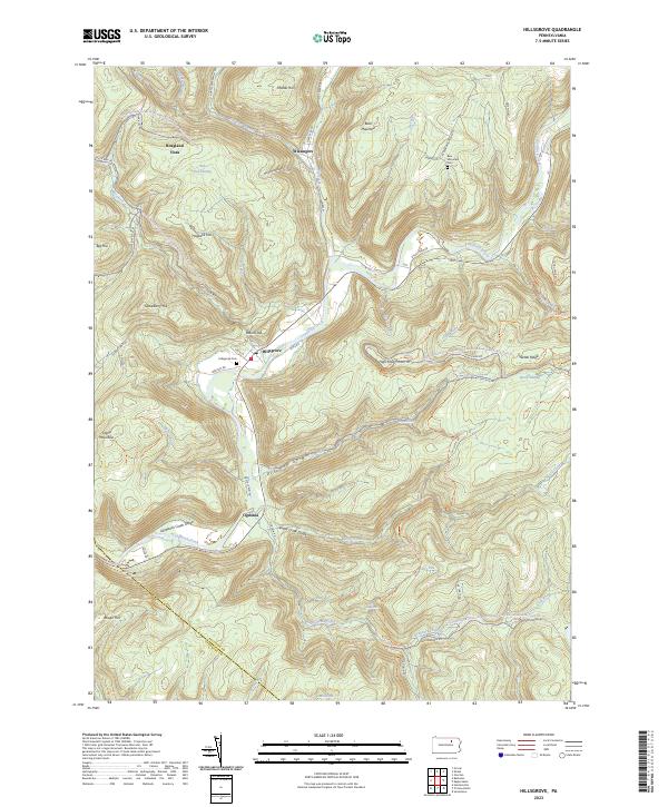 2023 Hillsgrove2023 Print · USGSSullivan County's deep valleys and timbered ridges are captured in this modern survey of the Loyalsock area. Researchers can find family cemeteries and remote settlements such as Hillsgrove, Ogdonia, and the riverfront grounds of Hillsgrove Cem.
 - 2023 Map of Barbours, 2023 Print
 2023 Barbours2023 Print · USGSThis Lycoming County high-country landscape shows the deep valleys and ridges of the Loyalsock region in the 2020s. Genealogists and local historians can locate family sites near Barbours, Proctor, and Hoppestown, or trace the old roads leading to Barbours Cem and Coal Mine Hollow.
 - 2023 Map of Montoursville North, 2023 Print
 2023 Montoursville North2023 Print · USGSNorth of Williamsport in the 2020s, the terrain rises into the high ridges of the Allegheny Plateau. Genealogists can locate several family burial sites including the Scott Family Graveyard and Quaker Hill Cem near Loyalsockville.
 - 2023 Map of Picture Rocks, 2023 Print
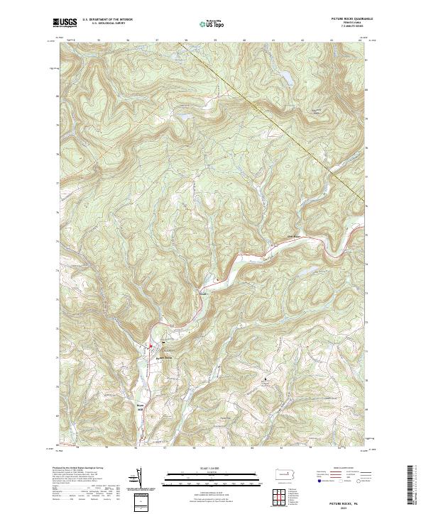 2023 Picture Rocks2023 Print · USGSLycoming County settlements and ridges appear in this 2023 survey of the Muncy Creek valley. Genealogists and hikers can locate Picture Rocks Cem, trace the Loyalsock Trl, or explore the hamlets of Tivoli and Bryan Mill.
End of results
Showing maps 1-5 of 5
Top cities near Plunketts Creek Township
- Williamsport historical maps
- South Williamsport historical maps
- Montoursville historical maps
- Kenmar historical maps
- Faxon historical maps
- Moreland Township historical maps
See more
Top neighborhoods of Plunketts Creek Township
Frequently asked questions
- What are the different types of historical maps available for Plunketts Creek Township?
- What is the oldest map of Plunketts Creek Township?
- Where can I purchase historical maps of Plunketts Creek Township for my home or office?
- Where can I download high-res historical maps of Plunketts Creek Township?
- Are there historical topographic maps available for Plunketts Creek Township?
- Is there historical aerial imagery available for Plunketts Creek Township?
- Where are historical maps of Plunketts Creek Township sourced from?