1960s Maps of Bratton Township, Pennsylvania
Explore 6 historic maps of Bratton Township from the 1960s. These maps offer a rare glimpse into what life looked like during the 1960s — showing old roads, neighborhoods, homes, and landmarks that have changed or disappeared over time.
Whether you're researching your family's past, planning a metal detecting trip, or studying how Bratton Township's landscape evolved across the 1960s, these high-resolution maps are a powerful tool for exploring the history of this region.
- Focus on a specific era: All maps on this page are from the 1960s, giving you a focused view of this time period.
- See what’s changed: Compare century-old streets, trails, and buildings to today's modern landscape using overlays and satellite layers.
- Research with precision: Use these maps for genealogy, historical research, land use analysis, or educational projects.
- View, download, or print: Maps are fully viewable online in high resolution, and can be downloaded or printed for your own records.
Start exploring Bratton Township's history through authentic maps from the 1960s. This is your window into the past.
Bratton Township, PA maps
(6)- 1960 Map of Mc Coysville, 1962 Print
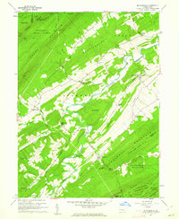 1960 Mc Coysville1962 Print · USGSJuniata County in the early sixties remains a landscape of traditional crossroads and mountain gaps. Genealogists can trace family footprints at McCullochs Mills, McCoysville Cem, and the small settlement of Honey Grove.3 unique versions available
 - 1961 Map of Harrisburg
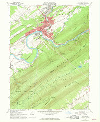
 1961 Harrisburg1961 Print · USGSCentral Pennsylvania is shown at a mid-century peak of industrial and military activity, from the Susquehanna water gaps to the fertile Dutch Country. Genealogists and historians can trace the rail corridors of the Pennsylvania RR and find landmarks like Carlisle Barracks or the Anthracite Coal Fields.2 unique versions available
 - 1961 Map of Mc Veytown, 1963 Print
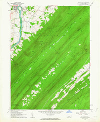 1961 Mc Veytown1963 Print · USGSMifflin County is defined by its dramatic mountain ridges and the winding Juniata River in the early sixties. Genealogists and local historians can trace family roots near McVeytown, Peru Mills, and the rural Pine Glen Ch nestled in the forest valleys.4 unique versions available
 - 1964 Map of Harrisburg
 1964 Harrisburg1964 Print · USGSCentral Pennsylvania in the mid-fifties reveals a landscape shaped by ridge-and-valley geology and critical Cold War infrastructure. Researchers can trace the massive Indiantown Gap Military Reservation or the rail corridors of the Pennsylvania RR and Reading RR.
 - 1966 Map of Lewistown, 1968 Print
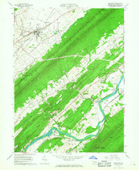
 1966 Lewistown1968 Print · USGSMid-century Mifflin County life is anchored by the rail and river corridors of the Junita River and Penn Central line. Researchers can locate community landmarks such as Black Hospital, Millers Tomb, and the Lind Memorial Cem.3 unique versions available
 - 1966 Map of Belleville, 1968 Print
 1966 Belleville1968 Print · USGSThe Kishacoquillas Valley and Juniata River corridor are captured in the mid-1960s, showing the intersection of ridge-top forests and productive bottomlands. Genealogists can trace family landmarks like Strodes Mills, Locust Grove Cemetery, and Wesley Chapel.2 unique versions available
End of results
Showing maps 1-6 of 6
Top cities near Bratton Township
- Lewistown historical maps
- Granville Township historical maps
- Decatur Township historical maps
- Mount Union historical maps
- Burnham historical maps
- Menno Township historical maps
See more
Top neighborhoods of Bratton Township
- Mattawana historical maps
- Longfellow historical maps
- Horningford historical maps
- Pine Glen historical maps
Frequently asked questions
- What are the different types of historical maps available for Bratton Township?
- What is the oldest map of Bratton Township?
- Where can I purchase historical maps of Bratton Township for my home or office?
- Where can I download high-res historical maps of Bratton Township?
- Are there historical topographic maps available for Bratton Township?
- Is there historical aerial imagery available for Bratton Township?
- Where are historical maps of Bratton Township sourced from?