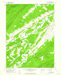
1960 Map of Mc Coysville
USGS Topo · Published 1962About this map
Tuscarora Creek meanders through a valley of small agricultural settlements and wooded ridges in this 1960 survey of Juniata County. The landscape is defined by the ridge-and-valley system of the Appalachians, with Shade Mountain and Tuscarora Mountain framing the central lowlands. Local commerce and community life center on historic hubs like McCoysville and Honey Grove, while the rural character is underscored by numerous stream-fed valleys such as Smoky Run and Willow Run. Genealogists can identify significant local landmarks including Rock Ch, Farmers Grove Ch, and the McCoysville Cem. The map captures the region's topography before significant modern development, showing the transition from the protected woodlands of the Tuscarora State Forest to the managed lands of State Game Lands No 215 and State Game Lands No 88.
Find a feature on this map
54 named features on this map. Tap any name to fly to it.
Don’t see what you’re looking for? This feature index may not catch every label — zoom into the map to look around manually.
Map Details
Editions of this 1960 Mc Coysville Map
3 editions found
Other maps of this area

1919 · Mattawana
USGS Topo · 1:62,500

1924 · Lewistown
USGS Topo · 1:62,500

1925 · Mifflintown
USGS Topo · 1:48,000

1927 · Lewisburg
USGS Topo · 1:62,500

1930 · Loysville
USGS Topo · 1:62,500

1933 · Loysville
USGS Topo · 1:62,500

1934 · Mifflintown
USGS Topo · 1:62,500

1936 · East Waterford
USGS Topo · 1:48,000

1937 · Mifflintown
USGS Topo · 1:62,500

1941 · East Waterford
USGS Topo · 1:62,500
Featured Places
- Spruce Hill Township, PA
- Milford Township, PA
- Reeds Gap, Tuscarora Township
- Beale Township, PA
- Doyles Mills, Beale Township