
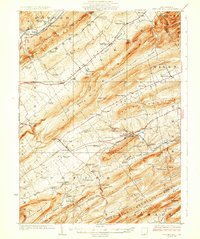
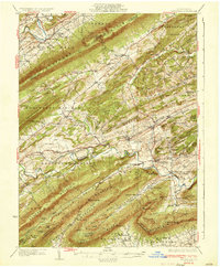
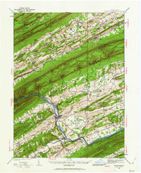
1925 Map of Mifflintown
USGS Topo · Published 1925About this map
The Juniata River carves a central path through this mid-1920s landscape, serving as a primary corridor for the Pennsylvania Railroad and defining the settlement patterns of Mifflintown, Mifflin, and Port Royal. This era shows a densely populated rural interior, where narrow valleys like Slim Valley and Pheasant Valley are punctuated by dozens of one-room schoolhouses, including the uniquely named Peach Blossom School and Verdant Lawn School. The industrial and agricultural economy of the day is evident in the numerous water-powered sites such as Jericho Mills, Raubs Mills, and Cuba Mills.
Find a feature on this map
114 named features on this map. Tap any name to fly to it.
Don’t see what you’re looking for? This feature index may not catch every label — zoom into the map to look around manually.
Map Details
Editions of this 1925 Mifflintown Map
This is the sole edition of this map. No revisions or reprints were ever made.
Other maps of this area

1907 · New Bloomfield
USGS Topo · 1:62,500

1907 · Millerstown
USGS Topo · 1:62,500

1919 · Mattawana
USGS Topo · 1:62,500

1924 · Centre Hall
USGS Topo · 1:62,500

1924 · Lewistown
USGS Topo · 1:62,500

1927 · Lewisburg
USGS Topo · 1:62,500
1929 · Centre Hall
USGS Topo · 1:62,500

1930 · Loysville
USGS Topo · 1:62,500
1933 · Loysville
USGS Topo · 1:62,500
1934 · Mifflintown
USGS Topo · 1:62,500