
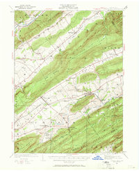
1924 Map of Centre Hall
USGS Topo · Published 1958About this map
Nittany Mountain and Bald Eagle Mountain define the topography of this region, creating a series of parallel ridges and fertile limestone valleys. In the early 1920s, the landscape was a dense network of small agricultural settlements and rural schoolhouses, such as Kennedy School, Hoy School, and Oak Grove School. The Pennsylvania RR follows the southern valley floor, serving stations like Rising Spring Sta near Spring Mills.
Find a feature on this map
113 named features on this map. Tap any name to fly to it.
Don’t see what you’re looking for? This feature index may not catch every label — zoom into the map to look around manually.
Map Details
Editions of this 1924 Centre Hall Map
2 editions found
Other maps of this area

1908 · Bellefonte
USGS Topo · 1:62,500

1909 · Bellefonte
USGS Topo · 1:62,500

1919 · Menno
USGS Topo · 1:62,500

1921 · Howard
USGS Topo · 1:48,000

1921 · Lock Haven
USGS Topo · 1:62,500

1923 · Howard
USGS Topo · 1:62,500

1923 · Lock Haven
USGS Topo · 1:62,500

1924 · Lewistown
USGS Topo · 1:62,500

1925 · Mifflintown
USGS Topo · 1:48,000

1927 · Lewisburg
USGS Topo · 1:62,500