
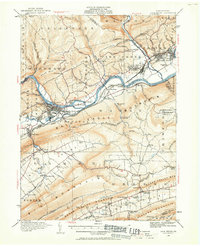
1921 Map of Lock Haven
USGS Topo · Published 1958About this map
Lock Haven serves as the focal point of this region, situated where the Susquehanna River West Branch meets Bald Eagle Creek. The settlement pattern in the early 1920s is defined by industrial and educational hubs, notably featuring the State Normal School and the rail corridors of the Pennsylvania and New York Central railroads. South of the river, the massive Bald Eagle Mountain separates the main valley from Sugar Valley, where smaller farming hamlets like Logan Mills and Booneville are nestled among a network of rural schools such as the Nippenose Red School. North of the Susquehanna, the Coudersport Pike winds through the hills toward Woolrich, an area dotted with numerous local landmarks including the Gravel Hill School and Liberty Church. The map provides an intricate look at the hydraulic and transport infrastructure of the era, from the Lock Haven Reservoir to the distinct river crossing at Lockport.
Find a feature on this map
112 named features on this map. Tap any name to fly to it.
Don’t see what you’re looking for? This feature index may not catch every label — zoom into the map to look around manually.
Map Details
Editions of this 1921 Lock Haven Map
2 editions found
Other maps of this area

1921 · Howard
USGS Topo · 1:48,000

1921 · Williamsport
USGS Topo · 1:48,000

1921 · Trout Run
USGS Topo · 1:62,500

1923 · Howard
USGS Topo · 1:62,500

1923 · Lock Haven
USGS Topo · 1:62,500

1923 · Trout Run
USGS Topo · 1:62,500

1923 · Williamsport
USGS Topo · 1:62,500

1924 · Centre Hall
USGS Topo · 1:62,500

1929 · Centre Hall
USGS Topo · 1:62,500

1935 · Waterville
USGS Topo · 1:24,000