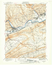
1921 Map of Lock Haven
USGS Topo · Published 1958About this map
Lock Haven and Jersey Shore anchor this 1921 survey, situated along the Susquehanna River West Branch in Clinton County. The landscape is defined by the narrow corridors of the Bald Eagle Valley and Sugar Valley Mountain, where settlement patterns follow the river and the branching rail lines of the New York Central and Pennsylvania railroads. In the town of Lock Haven, the State Normal School stands near the confluence of Bald Eagle Creek and the river, marking the community's early role as a regional center of education and commerce.
Find a feature on this map
113 named features on this map. Tap any name to fly to it.
Don’t see what you’re looking for? This feature index may not catch every label — zoom into the map to look around manually.
Map Details
Editions of this 1921 Lock Haven Map
2 editions found
Other maps of this area

1921 · Howard
USGS Topo · 1:48,000

1921 · Williamsport
USGS Topo · 1:48,000

1921 · Trout Run
USGS Topo · 1:62,500

1921 · Lock Haven
USGS Topo · 1:62,500

1923 · Howard
USGS Topo · 1:62,500

1923 · Lock Haven
USGS Topo · 1:62,500

1923 · Trout Run
USGS Topo · 1:62,500

1923 · Williamsport
USGS Topo · 1:62,500

1924 · Centre Hall
USGS Topo · 1:62,500

1929 · Centre Hall
USGS Topo · 1:62,500