
1930 Map of Loysville
USGS Topo · Published 1953About this map
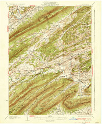
Tuscarora Mountain and Blue Mountain define the deep valley structure of Perry County in this 1930 survey, which captures the region's dense network of rural one-room schools and community centers. The landscape is dotted with local landmarks like St Paul Ch and the Boy Scout Camp, alongside numerous educational sites such as Academia Sch and Spring Dale Sch. The settlement pattern follows the drainages of Sherman Creek and Tuscarora Creek, with established villages like Loysville and Landisburg serving as central hubs for the surrounding townships. This map reveals a pre-industrial agricultural economy where small named ridges like Bernheisel Ridge and Hickory Ridge separated close-knit communities. The presence of features such as the Public Camp and various district schools highlights the transition between wilderness management and settled rural life in central Pennsylvania.
Find a feature on this map
114 named features on this map. Tap any name to fly to it.
Don’t see what you’re looking for? This feature index may not catch every label — zoom into the map to look around manually.
Map Details
Editions of this 1930 Loysville Map
This is the sole edition of this map. No revisions or reprints were ever made.
Other maps of this area

1904 · Carlisle
USGS Topo · 1:62,500

1907 · New Bloomfield
USGS Topo · 1:62,500

1907 · Millerstown
USGS Topo · 1:62,500

1919 · Newville
USGS Topo · 1:62,500

1919 · Mattawana
USGS Topo · 1:62,500

1923 · Shippensburg
USGS Topo · 1:62,500

1924 · Lewistown
USGS Topo · 1:62,500

1925 · Mifflintown
USGS Topo · 1:48,000

1927 · Lewisburg
USGS Topo · 1:62,500
1933 · Loysville
USGS Topo · 1:62,500
Featured Places
- Saville Township, PA
- Centre, Southwest Madison Township
- Spruce Hill Township, PA
- Landisburg, PA
- Milford Township, PA